MyTopo
Paxton Massachusetts US Topo Map
Couldn't load pickup availability
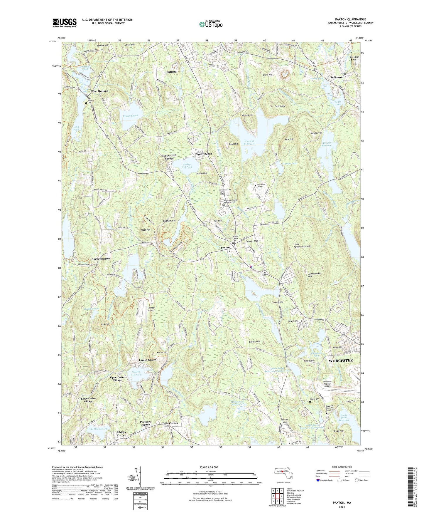
2021 topographic map quadrangle Paxton in the state of Massachusetts. Scale: 1:24000. Based on the newly updated USGS 7.5' US Topo map series, this map is in the following counties: Worcester. The map contains contour data, water features, and other items you are used to seeing on USGS maps, but also has updated roads and other features. This is the next generation of topographic maps. Printed on high-quality waterproof paper with UV fade-resistant inks.
Quads adjacent to this one:
West: North Brookfield
Northwest: Barre
North: Wachusett Mountain
Northeast: Sterling
East: Worcester North
Southeast: Worcester South
South: Leicester
Southwest: East Brookfield
Contains the following named places: Anna Maria College, Archway School, Asnebumskit Hill, Asnebumskit Pond, Asnebumskit Pond Dam, Bailey-Prouty Playground, Barrack Hill, Black Hill, Bond Hill, Brigham Hill, Browning Pond, Browning Pond Dam, Buck Hill, Buck Hill Conservation Dam, Buckhill Pond, Bumbo Brook, Camp Marshall, Camp Treasure Valley, Carey Hill, Caruth Brook, Central Tree Middle School, Christian Hill, Cooper Hill, Crocker Hill, David Prouty High School, Davis Hill, Demond Pond, Eagle Lake, Eames Pond, Eames Pond Dam, Eddy Hill, Elliott Hill, Fairbrook Country Club, First Congregational Church, Fox Hill, Grosvenor Reservoir, Harrington Pond, Holden Hills Country Club, Holden Reservoir Number One, Holden Reservoirs, Howe Hill, Jefferson, Jefferson Elementary School, Jefferson Post Office, Kendall Hill, Kendall Reservoir, Kettle Brook Reservoir Number 1 Dam, Kettle Brook Reservoir Number 2 Dam, Kettle Brook Reservoir Number 3 Dam, Kettle Brook Reservoir Number 4 Dam, Kettle Brook Reservoir Number Four, Kettle Brook Reservoir Number One, Kettle Brook Reservoir Number Three, Kettle Brook Reservoir Number Two, Lake Whittemore, Lake Whittemore Dam, Lambs Grove, Laurel Hill Park, Leicester High School, Leicester High School Library, Leicester Primary School, Little Asnebumskit Hill, Long Pond, Lower Wire Village, Lynde Brook Reservoir, Mannville, Maple Hill, McAuley Nazareth Home, Mooreland Cemetery, Moose Hill, Moose Hill Wildlife Management Area, Naguag School, Naquag Elementary School, Nazareth Home for Boys, North Spencer, Paxton, Paxton Center Schools, Paxton Fire Station, Paxton Police Station, Pemberton Station, Pine Hill, Pine Hill Reservoir, Proctors corner, Quaker Cemetery, Richards Memorial Library, Rocky Hill, Rutland, Rutland Census Designated Place, Rutland Sportsmens Club, Sandy Beach, Sargent Hill, Scott Brook, Shaw Brook, Shaw Pond Dam, Sibleys Corner, Silver Spring Brook, Smith Hill, Southwick Pond, Southwick Pond Dam, Spencer Airport, Streeter Pond, Streeter Pond Dam, Stump Pond, Sugden Reservoir, Sugden Reservoir Dam, Tafts Corner, Thompson Pond, Thompsons Pond Dam, Town of Paxton, Turkey Brook, Turkey Hill, Turkey Hill Pond, Turkey Hill Shores, Upper Wire Village, WAAF-FM (Worcester), Wadsworth Brook, WAYW-FM (Worcester), West Rutland, West Rutland Cemetery, White Hall, Whitehall Pond, Wire Village School, Worcester Brook, Worcester County, WSRS-FM (Worcester), WVNE-AM (Leicester), ZIP Code: 01612