MyTopo
Scituate Massachusetts US Topo Map
Couldn't load pickup availability
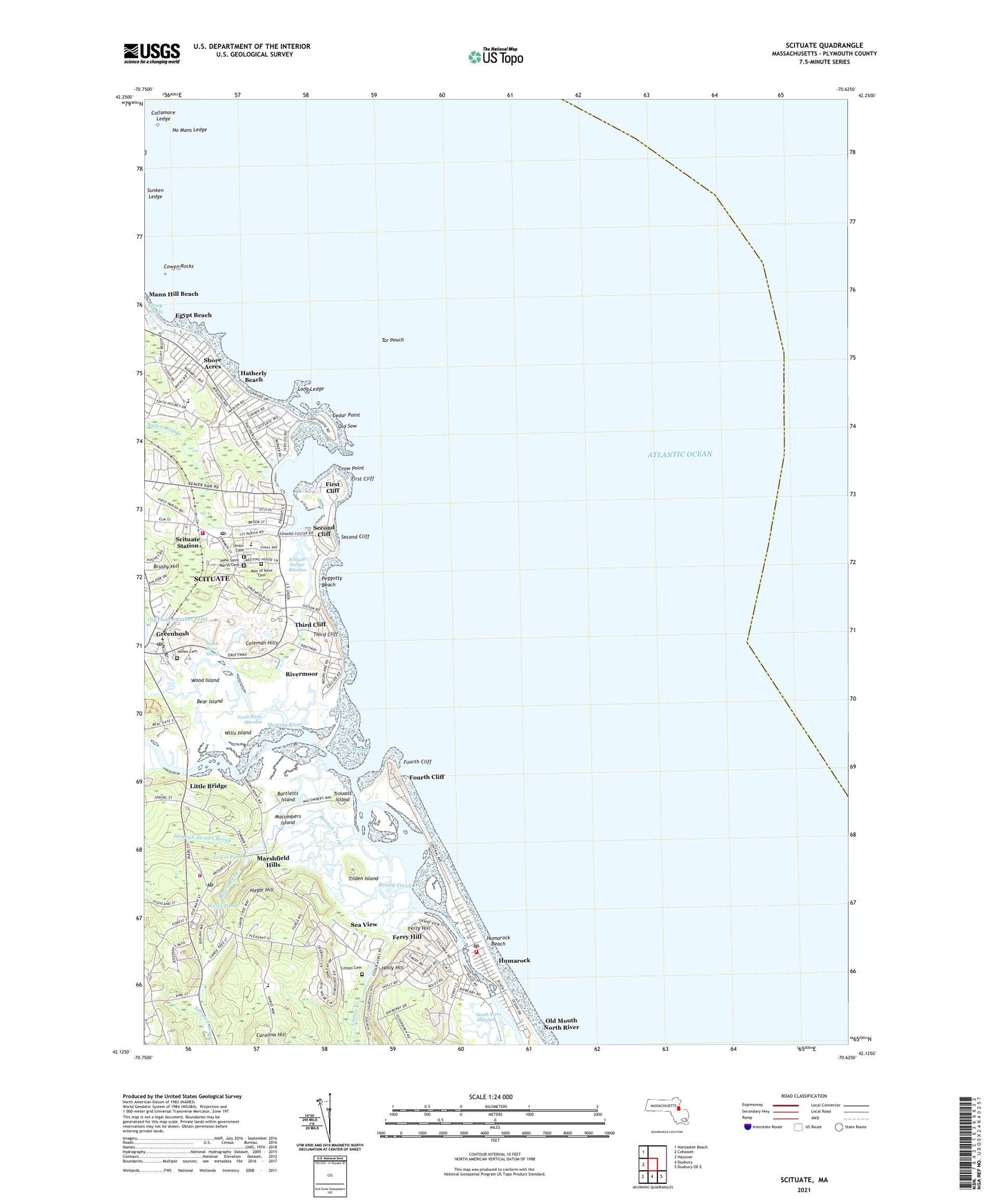
2024 topographic map quadrangle Scituate in the state of Massachusetts. Scale: 1:24000. Based on the newly updated USGS 7.5' US Topo map series, this map is in the following counties: Plymouth. The map contains contour data, water features, and other items you are used to seeing on USGS maps, but also has updated roads and other features. This is the next generation of topographic maps. Printed on high-quality waterproof paper with UV fade-resistant inks.
Quads adjacent to this one:
West: Cohasset
Northwest: Nantasket Beach
Southeast: Duxbury OE E
South: Duxbury
Southwest: Hanover
This map covers the same area as the classic USGS quad with code k42070b5.
Contains the following named places: Bares Brook, Bartletts Island, Bear Island, Branch Creek, Broad Creek, Brushy Hill, Carolina Hill, Cedar Point, Coleman Hills, Collamore Ledge, Cowen Rocks, Crow Point, Cushing Hall, Cushing Memorial State Park, Damon Point Road Dam, Eames Way School, East Marshfield Station, Egypt Beach, Ferry Hill, First Cliff, First Herring Brook, Fourth Cliff, Fourth Cliff United States Life Saving Station, Greenbush, Greenbush Post Office, Greenbush Station, Hagar Hill, Hannah Eames Brook, Hatherly Beach, Herring River, Holly Hill, Humarock, Humarock Beach, Humarock Post Office, James Cemetery, James Landing, Lewis Pond, Little Bridge, Little Cemetery, Littles Creek, Long Ledge, Macombers Creek, Macombers Island, Mann Hill Beach, Marshfield Fire Department Station 2, Marshfield Hills, Marshfield Hills Census Designated Place, Marshfield Hills Post Office, Men of Kent Cemetery, New Inlet, No Mans Ledge, North Community Church, North River, North River Marsh, North River Marshes, Old Mouth North River, Old Oaken Bucket Pond Dam, Old Sow, Peggotty Beach, Rivermoor, Saint Mary's Cemetery, Sand Hills, Satuit Boat Club, Satuit Brook, Scituate, Scituate Census Designated Place, Scituate Country Club, Scituate Fire Department Station 1 Headquarters, Scituate Fire Department Station 4, Scituate Harbor, Scituate Harbor Marina, Scituate Harbor Marshes, Scituate Harbor Yacht Club, Scituate Light, Scituate North Jetty Light, Scituate Post Office, Scituate Station, Scituate Town Pier, Sea View, Sea View Post Office, Sea View Station, Second Cliff, Sheep Ponds, Shore Acres, South River, Sunken Ledge, Tar Pouch, Third Cliff, Tilden Island, Town of Scituate, Trouant Island, Union Cemetery, Wales Pond, Wampatuck Elementary School, Widows Walk Golf Course, Wills Island, Wood Island, ZIP Code: 02047