MyTopo
Southbridge Massachusetts US Topo Map
Couldn't load pickup availability
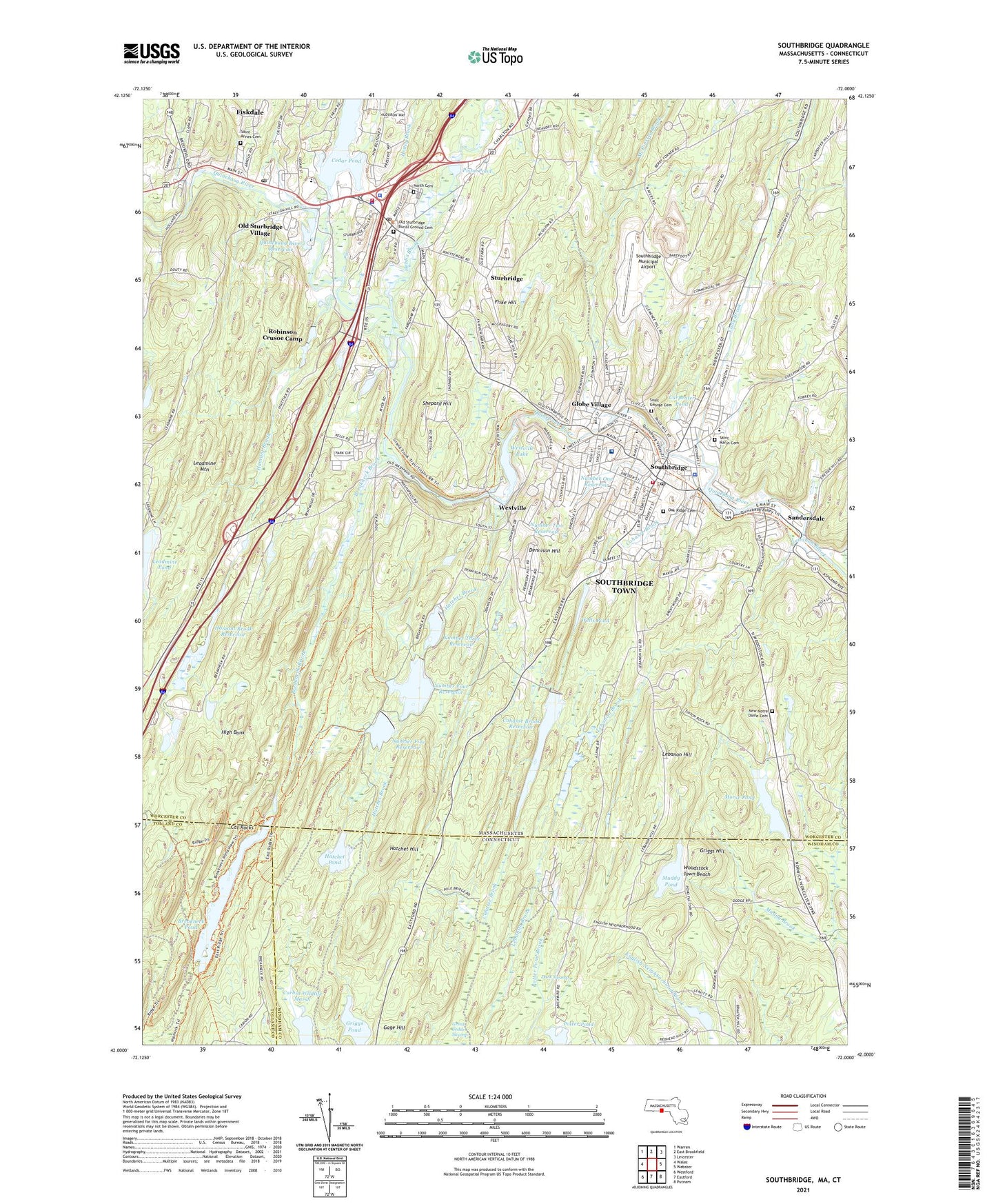
2024 topographic map quadrangle Southbridge in the states of Massachusetts, Connecticut. Scale: 1:24000. Based on the newly updated USGS 7.5' US Topo map series, this map is in the following counties: Worcester, Windham, Tolland. The map contains contour data, water features, and other items you are used to seeing on USGS maps, but also has updated roads and other features. This is the next generation of topographic maps. Printed on high-quality waterproof paper with UV fade-resistant inks.
Quads adjacent to this one:
West: Wales
Northwest: Warren
North: East Brookfield
Northeast: Leicester
East: Webster
Southeast: Putnam
South: Eastford
Southwest: Westford
This map covers the same area as the classic USGS quad with code k42072a1.
Contains the following named places: Academie Brochu, Ashland Mill Tenement, Bacon-Morse Historic District, Bethlehem Lutheran Church, Bixby House, Breakneck Brook, Breakneck Pond, Bullard Tavern, Burgess Elementary School, Burgess School, Cady Brook, Carpenter Pond, Cat Rocks, Cedar Brook, Cedar Pond, Cedar Pond Dam, Center Meetinghouse, Central Mills Historic District, Charlton Street School, City of Southbridge Town, Cohasse Brook, Cohasse Brook Reservoir, Cohasse Country Club Dam, Cohasse County Club, Cohasse Reservoir Dam, Corbin Wildlife Marsh, Dark Swamp, David C O'Brien Library Media Center, Dennison Hill, Diversion Dam, Eastford Road School, Elm Street Congregational Church, Elm Street Fire House, Faith Baptist Church, Fenno House, Fiskdale, Fiskdale Census Designated Place, Fiskdale Post Office, Fiske Hill, Fitch House, Freeman Farm, Friends Meetinghouse, Full Gospel Center, Gage Hill, Globe Village, Globe Village Fire House, Glover Street Historic District, Griggs Hill, Griggs Pond, Hamant Brook, Hamant Brook Reservoir, Hamilton Mill, Harriet Beecher Stowe Elementary School, Harrington Memorial Hospital, Hatchet Brook, Hatchet Hill, Hatchet Pond, Hatchet Pond Dam, High Bunk, High School Street Historic District, Hobbs Brook, Holy Trinity Church, Honey Brook, Iglesia Pentacostal Alpha Lota, J Cheney Wells Clock Gallery, Joan of Arc School, Joshua Hyde Public Library, Leadmine Mountain, Lebanon Hill, Lensdale Pond, Lensdale Pond Dam, Lyman Reservoir, Manna Campground, Marianhill High School, Mary E Wells Junior High School, Mary E Wells Junior High School Media Center, Massachusetts State Police Station C5 Sturbridge Barracks, McKinstry Brook, Morse Pond, Muddy Pond, New Notre Dame Cemetery, North Cemetery, Notre Dame Church, Notre Dame School, Number Five Reservoir, Number Five Reservoir Dam, Number Four Reservoir, Number Four Reservoir Dam, Number One Reservoir, Number Three Reservoir, Number Two Reservoir, Oak Ridge Cemetery, Old Sturbridge Village, Old Sturbridge Village Visitor Center, Outdoor World Campground, Photomobile Model Museum, Pistol Pond, Potter Pond, Potter Pond Brook, Prindle Lake Dam, Quinebaug River Reservoir, Reservoir Number Three Dam, River Street School, Robinson Crusoe Camp, Russell Harrington Mill Pond Dam, Saint Annes Cemetery, Saint Annes Shrine, Saint George Cemetery, Saint Georges Greek Orthodox Church, Saint Mary Camp, Saint Marys Cemetery, Saint Marys School, Saint Nicholas Albanian Church, Sandersdale, Shepard Hill, Snellville, Solair Recreation League, Southbridge, Southbridge Census Designated Place, Southbridge Christian Academy, Southbridge Church of God, Southbridge Fire Department Station 1 Headquarters, Southbridge High School, Southbridge Methodist Church, Southbridge Municipal Airport, Southbridge Plaza, Southbridge Police Department, Southbridge Post Office, Southbridge Town Hall, Southbridge Townhall, Sturbridge, Sturbridge Census Designated Place, Sturbridge Common Historic District, Sturbridge Federated Church, Sturbridge Fire Department, Sturbridge Plaza, Sturbridge Police Department, Sturbridge Post Office, Sturbridge Village Pond Dam, Town of Sturbridge, Upper Chapin Street Historic District, Wallace Pond Dam, Wells Pond, West Street School, Westville, Westville Dam, Westville Lake, Windsor Court Historic District, Woodstock Town Beach, ZIP Codes: 01550, 01566