MyTopo
Townsend Massachusetts US Topo Map
Couldn't load pickup availability
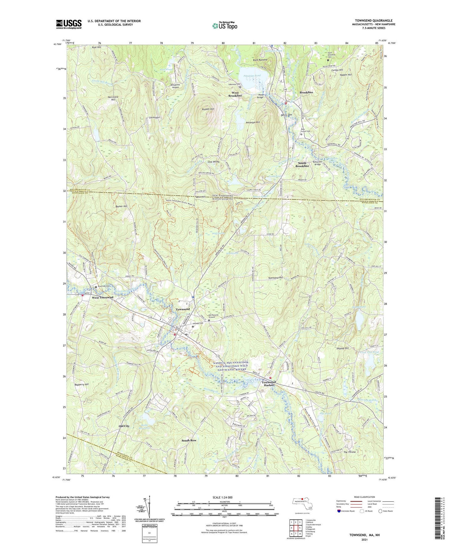
2021 topographic map quadrangle Townsend in the states of Massachusetts, New Hampshire. Scale: 1:24000. Based on the newly updated USGS 7.5' US Topo map series, this map is in the following counties: Middlesex, Hillsborough, Worcester. The map contains contour data, water features, and other items you are used to seeing on USGS maps, but also has updated roads and other features. This is the next generation of topographic maps. Printed on high-quality waterproof paper with UV fade-resistant inks.
Quads adjacent to this one:
West: Ashby
Northwest: Greenville
North: Milford
Northeast: South Merrimack
East: Pepperell
Southeast: Ayer
South: Shirley
Southwest: Fitchburg
Contains the following named places: Adams Dam, Babb Swamp, Barker Hill, Bayberry Hill, Bayberry Hill Brook, Bixby Brook, Bixby Reservoir, Bixby Reservoir Dam, Bladderwort Bog, Bohannon Bridge, Brookline, Brookline Airport, Brookline Ambulance Service, Brookline Fire Department, Brookline Police Department, Brookline Public Library, Brookline Ski Area, Campbells Meadow, Captain Samuel Douglass Academy, Center Cemetery, Church of Christ, Cider Mill Pond, Coon Tree Pond, Coreys Hill, Daniels Academy, Dead Pond, Dead Swamp, Devils Den, East Branch Village Brook, Flat Pond, Gould Mill Brook, Graves Pond, Greater Grace Community Church, Gulf Brook, Harbor Pond, Hawthorne Brook Elementary School, Hawthorne Brook Middle School, Hawthorne Brook Middle School Library, Heald Pond, Heald Pond Dam, Hillside Cemetery, Hobart Hill, Hurricane Hill, Lakeview Cemetery, Lancy Brook, Lost Valley, Marshalls Pond, Mason Road Dam, North Middlesex Regional High School, North Stream, No-See-Um Brook, Nutting Stream, Old Burying Ground, Old City, Pierce Pond, Pine Grove Cemetery, Pond Bridge, Potanipo Hill, Potanipo Pond, Potanipo Pond Dam, Pout Pond, Richard Maghakian Memorial School, Riverside Cemetery, Rock Ramond, Rocky Pond Brook, Russell Hill, Saint Anthonys Cemetery, Shipley Hill, Skeeter Brook, South Brookline, South Row, Spaulding Memorial School, Squannacook Elementary School, Squannacook River Reservoir, Squannacook River State Wildlife Management Area, Squannock School, Stewart Brook, Stickney Brook, Stonefly Bog, Stonefly Brook, Stonehouse Brook, Talbot Brook, Talbot Swamp, Taylor Pond, Taylor Pond Dam, The Stonehouse, The Throne, Town of Brookline, Town of Mason, Town of Townsend, Townsend, Townsend Census Designated Place, Townsend Congregational Church, Townsend Fire Department Emergency Medical Service, Townsend Fire Department Headquarters, Townsend Fire Department Station 1 Annex, Townsend Fire Department Station 2 West Townsend, Townsend Fire Department Station 3, Townsend Fire Department Station 3 Townsend Harbor, Townsend Harbor, Townsend Harbor Dam, Townsend Hill, Townsend Police Department, Townsend Post Office, Townsend Public Library, Townsend Shopping Center, Townsend State Forest, Townsend Town Hall, Townsend United Methodist Church, Trout Brook, Trout Pond, Village Brook, Walker Pond, Wallace Brook, Water Mite Brook, West Branch Village Brook, West Brookline, West Hill, West Townsend, Willard Brook, Williams Pond, Witch Brook, Wolf Brook, Wolf Swamp, Zim Airport, ZIP Codes: 01469, 03033