MyTopo
South Merrimack New Hampshire US Topo Map
Couldn't load pickup availability
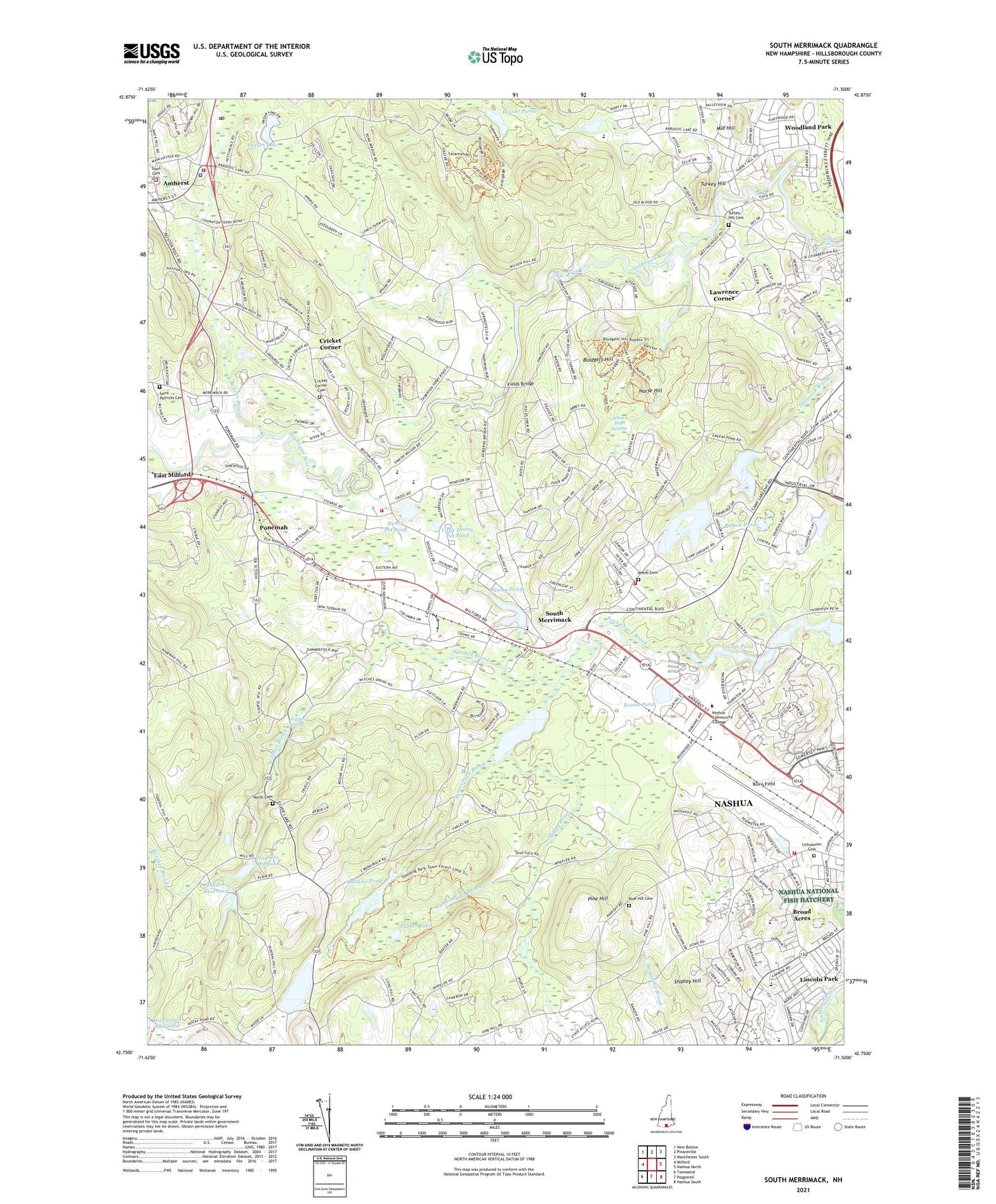
2024 topographic map quadrangle South Merrimack in the state of New Hampshire. Scale: 1:24000. Based on the newly updated USGS 7.5' US Topo map series, this map is in the following counties: Hillsborough. The map contains contour data, water features, and other items you are used to seeing on USGS maps, but also has updated roads and other features. This is the next generation of topographic maps. Printed on high-quality waterproof paper with UV fade-resistant inks.
Quads adjacent to this one:
West: Milford
Northwest: New Boston
North: Pinardville
Northeast: Manchester South
East: Nashua North
Southeast: Nashua South
South: Pepperell
Southwest: Townsend
This map covers the same area as the classic USGS quad with code o42071g5.
Contains the following named places: Amherst Census Designated Place, Amherst Christian Church, Amherst Country Club, Amherst Emergency Medical Services, Amherst Fire Department Station 2, Amherst Fire Rescue Department Station 1, Amherst Middle School, Amherst Police Department, Amherst Post Office, Beaver Brook, Beaver Ponds, Birch Hill Elementary School, Blodgett Hill, Blood, Boire Field, Broad Acres, Broad Street Elementary School, Brookside Hospital, Brookside Hospital Professional Library, Camp Naticook, Camp Sargent, Christ the King Lutheran Church, Cricket Corner, Cricket Corner Cemetery, Daniel Webster College, Daniel Webster College Emergency Medical Services, Daniel Webster College Library, Dream Lake, Duck Pond, Dunklee Pond, Dunklee Pond Dam, Farley Brook Dam, Fields Bridge, First Baptist Church, Greens Pond, Haydens Mill Pond Dam, Haydens Millpond, Haydens Reservoir, Hodgman State Forest, Holt Dam, Holts Pond, Honey Pot Pond, Horse Hill, Lawrence Corner, Lincoln Park, Lithuanian Cemetery, Little Honey Pot Pond, Merrimack Fire Department Station 2, Merrimack Heliport, Merrimack Middle School, Middle Hill, Muddy Brook, Nasha Brookside Hospital, Nashua Fire and Rescue Station 5, Nashua High School North, Naticook Lake, Naticook Lake Dam, New Hampshire Technical School, Norden Systems Heliport, North Cemetery, Northeast Rehabilitation Hospital, Parker Pond, Parker Pond Brook, Pennichuck Pond, Pennichuck Square Shopping Center, Pine Hill, Pine Hill Cemetery, Ponemah, Ponemah Bog Wildlife Refuge, Ponemah Forest, Reeds Cemetery, Round Pond, Saint Lukes Anglican Church, Saint Patricks Cemetery, Shipley Hill, Silver Lake, Silver Lake State Park, Souhegan High School, South Merrimack, South Merrimack Christian Academy, South Merrimack Congregational Church, Stump Pond, Thorntons Ferry Elementary School, Town Cemetery, Town of Amherst, Town of Merrimack, Trafalgar Square, Turkey Hill, Turkey Hill Cemetery, Veterans Memorial Park, Wasseman Park, White Pine Swamp, Wildcat Falls, Witches Brook, Witches Spring, Woodland Park, ZIP Codes: 03031, 03054, 03063