MyTopo
Pepperell Massachusetts US Topo Map
Couldn't load pickup availability
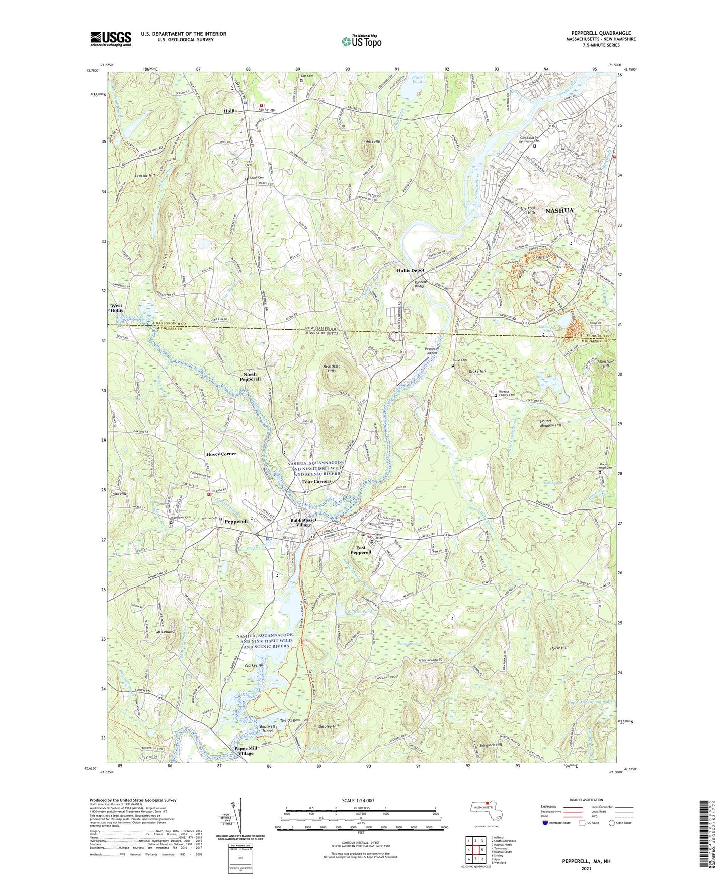
2024 topographic map quadrangle Pepperell in the states of Massachusetts, New Hampshire. Scale: 1:24000. Based on the newly updated USGS 7.5' US Topo map series, this map is in the following counties: Middlesex, Hillsborough. The map contains contour data, water features, and other items you are used to seeing on USGS maps, but also has updated roads and other features. This is the next generation of topographic maps. Printed on high-quality waterproof paper with UV fade-resistant inks.
Quads adjacent to this one:
West: Townsend
Northwest: Milford
North: South Merrimack
Northeast: Nashua North
East: Nashua South
Southeast: Westford
South: Ayer
Southwest: Shirley
Contains the following named places: Autumn Hill Orchards, Babbatasset Village, Bancroft Brook, Baralock Hill, Bartemus Brook, Beaver Brook, Beaver Brook Association Pond, Blanchard Hill, Blood Cemetery, Boutwell Island, Burkinshaws Factory, C Lawrence Library, Christadelphian Church, Church of the Holy Spirit, Clarkes Hill, Congregational Church of Hollis, Cow Pond Brook, Drake Hill, East Cemetery, East Pepperell, East Pepperell Census Designated Place, Faith Baptist Church of Hollis, Fitzpatrick School, Flints Brook, Flints Hill, Flints Pond, Four Corners, Grace Baptist Church, Gratuity Brook, Green Acres Trailer Park, Green Street School, Greens Brook, Hauk Swamp, Hawk Pond, Hollis, Hollis Brookline High School, Hollis Brookline Middle School, Hollis Depot, Hollis Fire Department, Hollis Hof Ski Touring Center, Hollis Post Office, Hollis Primary School, Hollis Town Hall, Hollis Town Police Department, Hollis Upper Elementary School, Horse Hill, Hound Meadow Hill, Hovey Corner, J Harry Rich State Forest, Kimball Fruit Farms, Lomar Industrial Park, Lovewell Pond, Main Dunstable Elementary School, Mapledene Elementary School, Mine Brook, Mine Falls Dam, Mine Falls Park, Mount Hermon Cemetery, Mount Lebanon, Nashua Baptist Church, Nashua Fire and Rescue Station 6, Nashua River Reservoir, Nissitissit Hills, Nissitissit Middle School, Nissitissit Middle School Library Media Center, Nissitissit River, Nissitissit River Reservoir, Nissitissit Wildlife Management Area, Nod Brook, North Pepperell, Oak Hill, Paper Mill Village, Pepperell, Pepperell Airport, Pepperell Census Designated Place, Pepperell Christian Fellowship Church, Pepperell Fire Department Headquarters, Pepperell Fire Department Station 2, Pepperell Fire Department Station 3, Pepperell Paper Company Dam, Pepperell Police Department, Pepperell Post Office, Pepperell Town Hall, Peter Fitzpatrick School, Peter Fitzpatrick School Library, Pork Barrel Pond, Proctor Hill, Reedy Meadow, Reedy Meadow Brook, Robinson Brook, Rocky Pond Brook Dam, Runnells Bridge, Saint Josephs Cemetery, Saint Louis De Gonzagues Cemetery, Shepley Hill, South Cemetery, South Pepperell, Suburban Village Trailer Park, Sucker Brook, The Barn Heliport, The Four Hills, The Ox Bow, Town of Dunstable, Town of Hollis, Town of Pepperell, Turner Dam, Unkety Brook, Varnum Brook, Varnum Brook Elementary School Media Center, Varnum Brook Middle School, Walton Cemetery, Wattles Pond, West Hollis, Woodlawn Cemetery, ZIP Codes: 01463, 03049, 03062