MyTopo
Blue Hills Massachusetts US Topo Map
Couldn't load pickup availability
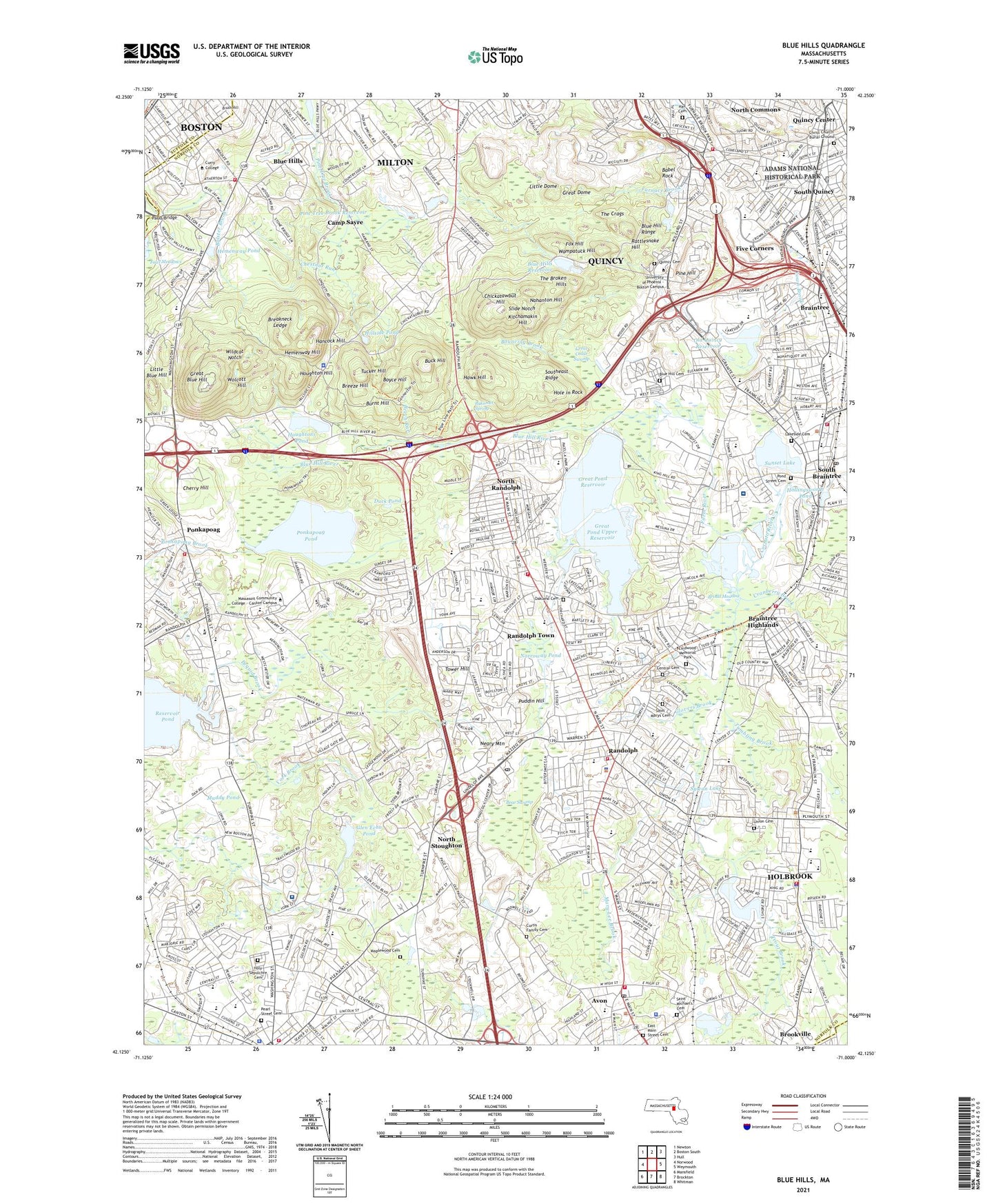
2024 topographic map quadrangle Blue Hills in the state of Massachusetts. Scale: 1:24000. Based on the newly updated USGS 7.5' US Topo map series, this map is in the following counties: Norfolk, Suffolk, Plymouth. The map contains contour data, water features, and other items you are used to seeing on USGS maps, but also has updated roads and other features. This is the next generation of topographic maps. Printed on high-quality waterproof paper with UV fade-resistant inks.
Quads adjacent to this one:
West: Norwood
Northwest: Newton
North: Boston South
Northeast: Hull
East: Weymouth
Southeast: Whitman
South: Brockton
Southwest: Mansfield
Contains the following named places: Adamsville, Ames Pond, Angelos Shopping Center, Angelo's Shopping Center, Archbishop Williams High School, Avon, Avon High School, Avon Industrial Park, Avon Middle School, Avon Plaza Shopping Center, Babel Rock, Balster Brook, Battery March Park, Bear Swamp, Beech Run, Belcher Park, Belcher School, Belchers Corner, Blue Hill Cemetery, Blue Hill Range, Blue Hill River, Blue Hills, Blue Hills Regional School, Blue Hills Reservoir, Blue Hills Reservoir Dam, Bouncing Brook, Boyce Hill, Braintree Census Designated Place, Braintree Five Corners Center, Braintree Five Corners Center Shopping Center, Braintree High School, Braintree Highlands, Braintree Junior High School, Braintree Place Shopping Center, Braintree Station, Breakneck Ledge, Breeze Hill, Broad Meadow, Brookville, Brush Hill, Buck Hill, Burlington Plaza Shopping Center, Burnt Hill, Camp Dorchester, Camp Sayre, Campanelli Industrial Park, Canton Commerce Center, Central Cemetery, Charles G Devine School, Cherry Hill, Chestnut Run, Chickatawbut Hill, Chickatawbut Observation Tower, Christ Church Burial Ground, City of Braintree Town, City of Randolph Town, Cobbs Corner Shopping Center, Cochato River, Colbert School, Coon Hollow Brook, Cranberry Brook, Cranch School, Crowley School, Curry College, Duck Pond, Dyer Hill Playground, East Randolph Industrial Park, Elizabeth G Lyons Elementary School, Fairmount School, Farm River, Fernandes Randolph Shoppers Plaza, Five Corners, Foster School, Four Corners, Fox Hill, Franklin School, Frenchs Commons, Garfield School, Glen Echo Pond, Glovers Brook, Granite Plaza Shopping Center, Great Blue Hill, Great Cedar Swamp, Great Dome, Great Pond, Great Pond Dam, Great Pond Reservoir, Great Pond Upper Reservoir, Great Pond Upper Reservoir Dam, Hall Cemetery, Hancock Hill, Hawk Hill, HealthSouth Braintree Rehabilitation Hospital, Hemenway Hill, Hemenway Pond, Hillside Pond, Holbrook, Holbrook Census Designated Place, Holbrook High School, Holbrook-Randolph Station, Hole in Rock, Hollingsworth Pond, Hollis Field, Hollis School, Holy Sepulchre Cemetery, Houghton Hill, Houghtons Pond, John F Kennedy Junior High School, Kincaide Park, Kings Shopping Center, Kitchamakin Hill, Lake Holbrook, Lake Holbrook Dam, Lakeside Cemetery, Lakeside School, Lincoln-Hancock Community School, Lindwood Memorial Park, Little Blue Hill, Little Dome, Maplewood Cemetery, Margaret L Donovan School, Martin Brook, Martin E Young Elementary School, Mary Lee Brook, Mayflower Park Station, McNeill School, Milton, Milton Census Designated Place, Monatiquet School, Muddy Pond, N E Hollis Memorial Golf Course, Nahanton Hill, Neary Mountain, New England Sinai Hospital, New England Sinai Hospital and Rehabilitation Center, New Highland Plaza, New Highland Plaza Shopping Center, Norfolk County Hospital, Norroway Brook, Norroway Pond, North Commons, North Elementary School, North Junior High School, North Randolph, North Stoughton, North Stoughton Station, Oakland Cemetery, Old Quincy Reservoir, Old Quincy Reservoir Dam, Pacelle Industrial Park, Pakomet Spring, Park Plaza, Pauls Bridge, Pearl Plaza Shopping Center, Pearl Street Cemetery, Pine Hill, Pine Tree Brook Dam, Pine Tree Brook Reservoir, Pine Tree Brook Reservoir Dam, Pond Street Cemetery, Ponkapoag, Ponkapoag Golf Club, Ponkapoag Pond, Popes Pond, Puddin Hill, Quincy Cemetery, Quincy Center, Quincy Junior High School, Quincy Station, Randolph, Randolph Census Designated Place, Randolph Country Club, Randolph High School, Rattlesnake Hill, Reservoir Pond, Ridge Raquet Club, Saint Colettas School, Saint Columbians Seminary, Saint Johns School, Saint Josephs School, Saint Marys Cemetery, Saint Marys School, Saint Michael's Cemetery, Saint Moritz Park, Shea Park, Slide Notch, South Quincy, South School, South Shore Plaza, South Shore Plaza Shopping Center, Southeast Ridge, Star Market Shopping Center, Stetson Brook, Stetson School, Stoughton, Stoughton Center Shopping Center, Stoughton High School, Stoughton Junior High School, Sumner School, Sunset Lake, Sylvan Lake, Thayer Academy, The Broken Hills, The Crags, The Plaza, The Plaza Shopping Center, Three Swamp Brook, Torrey School, Tower Hill, Tower Hill School, Town of Avon, Town of Holbrook, Town of Milton, Tri-Town Shopping Center, Trout Brook, Tucker Hill, Tumbling Brook, Union Cemetery, Wampatuck Country Club, Wampatuck Hill, West Corners, West Elementary School, West Stoughton, WGBH-FM (Boston), Wildcat Notch, Willard School, WMLN-FM (Milton), Wolcott Hill, York Avenue Industrial Park, York Brook, ZIP Codes: 02169, 02184, 02186, 02322, 02368