MyTopo
Weymouth Massachusetts US Topo Map
Couldn't load pickup availability
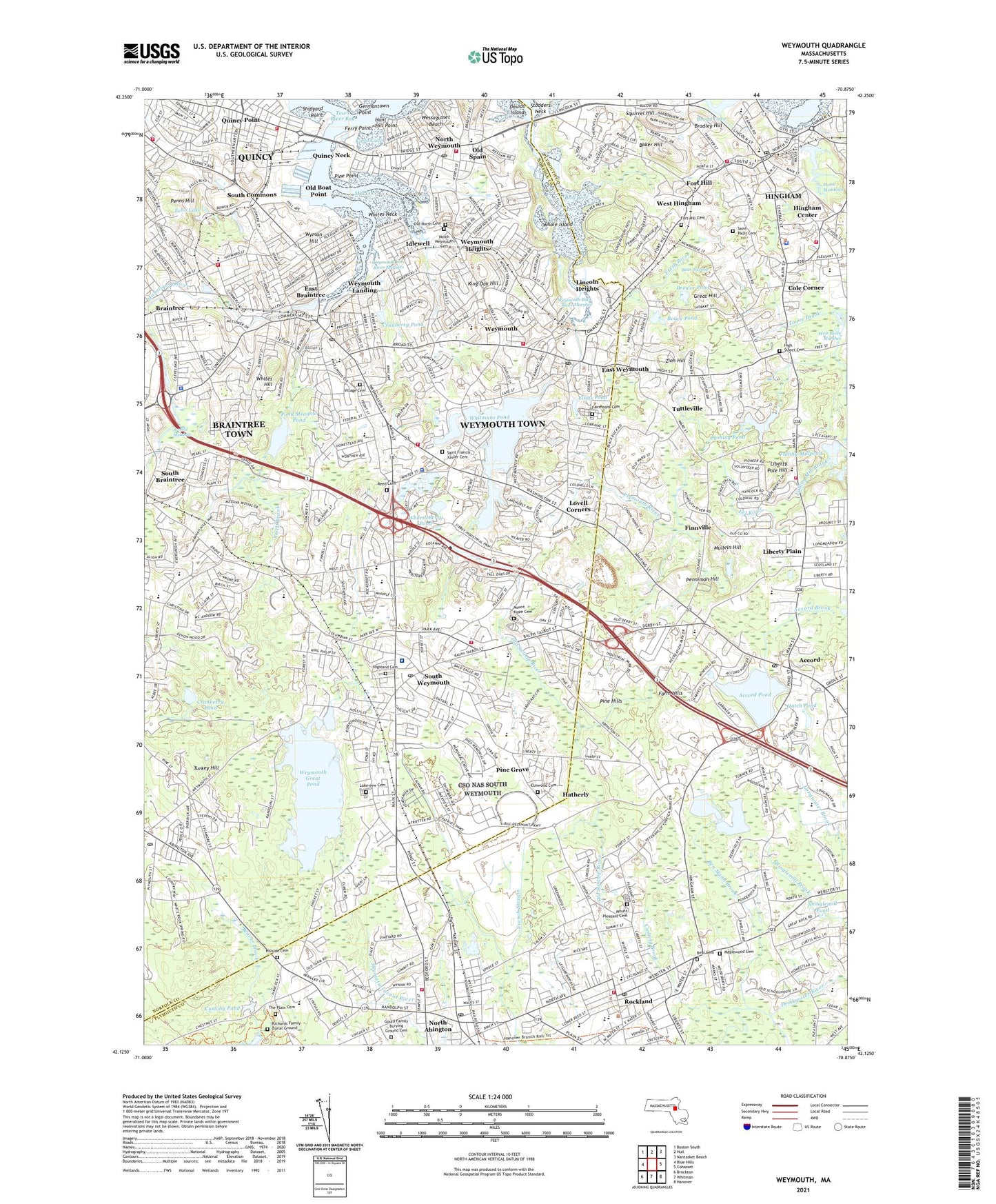
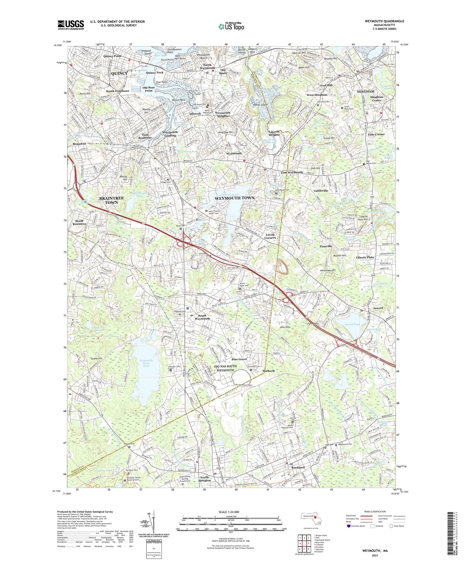
2024 topographic map quadrangle Weymouth in the state of Massachusetts. Scale: 1:24000. Based on the newly updated USGS 7.5' US Topo map series, this map is in the following counties: Norfolk, Plymouth. The map contains contour data, water features, and other items you are used to seeing on USGS maps, but also has updated roads and other features. This is the next generation of topographic maps. Printed on high-quality waterproof paper with UV fade-resistant inks.
Quads adjacent to this one:
West: Blue Hills
Northwest: Boston South
North: Hull
Northeast: Nantasket Beach
East: Cohasset
Southeast: Hanover
South: Whitman
Southwest: Brockton
This map covers the same area as the classic USGS quad with code k42070b7.
Contains the following named places: Accord, Accord Pond, Accord Pond Dam, Adams Street Burying Ground Site, Alice Fulton School, Ames Nowell State Park, Archie T Morrison School, Arnold Meadow, Baker Hill, Baxter Street Historic District, Beal Cemetery, Beal Cove, Beals Park, Bear Swamp, Ben Mann Brook, Bents Creek, Bouve Pond, Bradford Hawes Park, Bradley Hill, Braintree, Brewer Pond, Broad Cove, City of Weymouth Town, Clapp Memorial Park, Clean Harbors Heliport, Cobb Family Burying Ground, Cole Corner, Cole Corner High School, Cranberry Pond, Crooked Meadow River, Cushing Family Tomb Site, Cushing Pond, Cushing Pond Dam, Davids Island, Derby Academy, East Braintree, East Weymouth, Eatons Pond, Echo Lake, Eel River, Elias Pond, Ellias Pond, Elmwood Cemetery, Fairmount Cemetery, Farm Hills, Faxon Park, Ferry Point, Finnville, Fort Hill, Fort Hill Cemetery, Frederick C Murphy School, Fresh River, Fulling Mill Brook, Fulling Millpond, Fulling Millpond Dam, Gagnon Park, Germantown Point, Gould Family Burying Ground Cemetery, Grace Farrar Cole School, Great Hill, Hackett Pond Dam, Hanover Junior High School, Harbor Light Mall Shopping Center, Harborlight Mall, Hatch Pond, Hatherly, Hayward Creek, High Street Cemetery, Highland Cemetery, Hillside Cemetery, Hingham, Hingham Census Designated Place, Hingham Center, Hingham Center Central Junior High School, Hingham Shopping Plaza, Hingham Station, Holy Family School, Home Meadows, Homestead School, House Rock Park, Hunt Family Tomb Site, Hunt Hill Point, Idlewell, King Oak Hill, Kings Cove, Lakeview Cemetery, Legion Field, Libby Field, Liberty Plain, Liberty Pole Hill, Liberty School, Lincoln Heights, Lincoln Historic District, Lincoln School, Lovell Corners, Lovell Playground, Lower Union Street Historic District, Maplewood Cemetery, McKinley School, Mill Cove, Mill River, Mill Woods, Monatiquot River, Mount Hope Cemetery, Mount Pleasant Cemetery, Mullein Hill, Nash School, Naval Air Station South Weymouth, Negus Playground, Nevin School, Newell Playground, North Abington, North Abington Depot, North Abington Station, North School, North Weymouth, North Weymouth Cemetery, Norwell Industrial Park, Notre Dame Academy, Old Boat Point, Old North Cemetery, Old Spain, Old Swamp River, Penniman Hill, Penniman School, Penns Hill, Perkins School, Pine Grove, Pine Hills, Pine Point, Pleasant Shops Shopping Center, Plymouth River, Plymouth River School, Pollard School, Pond Meadow Lake Reservoir, Pond Meadow Pond, Pratt School, President Plaza Shopping Center, Presidents Plaza Shopping Center, Quincy Mental Health Center, Quincy Neck, Quincy Point, Quincy Shipyard, Quintree Mall Shopping Center, Ralph Talbot School, Reed Cemetery, Richards Family Burial Ground, Robert S Hoffman Park, Rockland, Rockland High School, Rockland Junior High School, Rockland Station, Rocky Woods, Route 3 Industrial Park, Sacred Heart School, Saint Francis Xavier Cemetery, Saint Francis Xavier School, Saint Josephs School, Saint Paul's Cemetery, Saint Pauls School, Saint Thomas Mores School, Shinglemill Pond, Shipyard Point, Smelt Brook, Smelt Brook Dam, South Braintree, South Commons, South High School, South Junior High School, South Middle School, South School, South Shore Consumers Mall, South Shore Country Club, South Shore Hospital, South Shore Industrial Park, South Weymouth, South Weymouth Junior High School, South Weymouth Station, Southfield Census Designated Place, Squirrel Hill, Stodders Neck, Talbot Field, Tedeschi Plaza Shopping Center, Tedeschi Shopping Center, The Plain Cemetery, Tims Pond, Tirrell Playground, Tower Brook, Town of Hingham, Town of Rockland, Town River Bay, Turkey Hill, Tuttleville, Union Street School, Victory Park, Village Cemetery, Watson Park, Watson School, Webb Park, Weir River Marshes, Wessagusset Beach, West Hingham, West Hingham Station, Weston Park, Weymouth, Weymouth Back River Marshes, Weymouth Census Designated Place, Weymouth Fore River Marshes, Weymouth Great Pond, Weymouth Great Pond Dam, Weymouth Heights, Weymouth Industrial Park, Weymouth Landing, Weymouth Shopping Center, Weymouth Village, Weymouth Village Shopping Center, Weymouth-Braintree Regional Recreation Conservation Area, Whale Island, Whites Hill, Whites Neck, Whitmans Pond, Whitmans Pond Dam, Whortleberry Pond, William Seach School, Woodsdale School, WRPS-FM (Rockland), Wyman Hill, Zion Hill, ZIP Codes: 02043, 02188, 02189, 02190, 02191, 02343, 02370