MyTopo
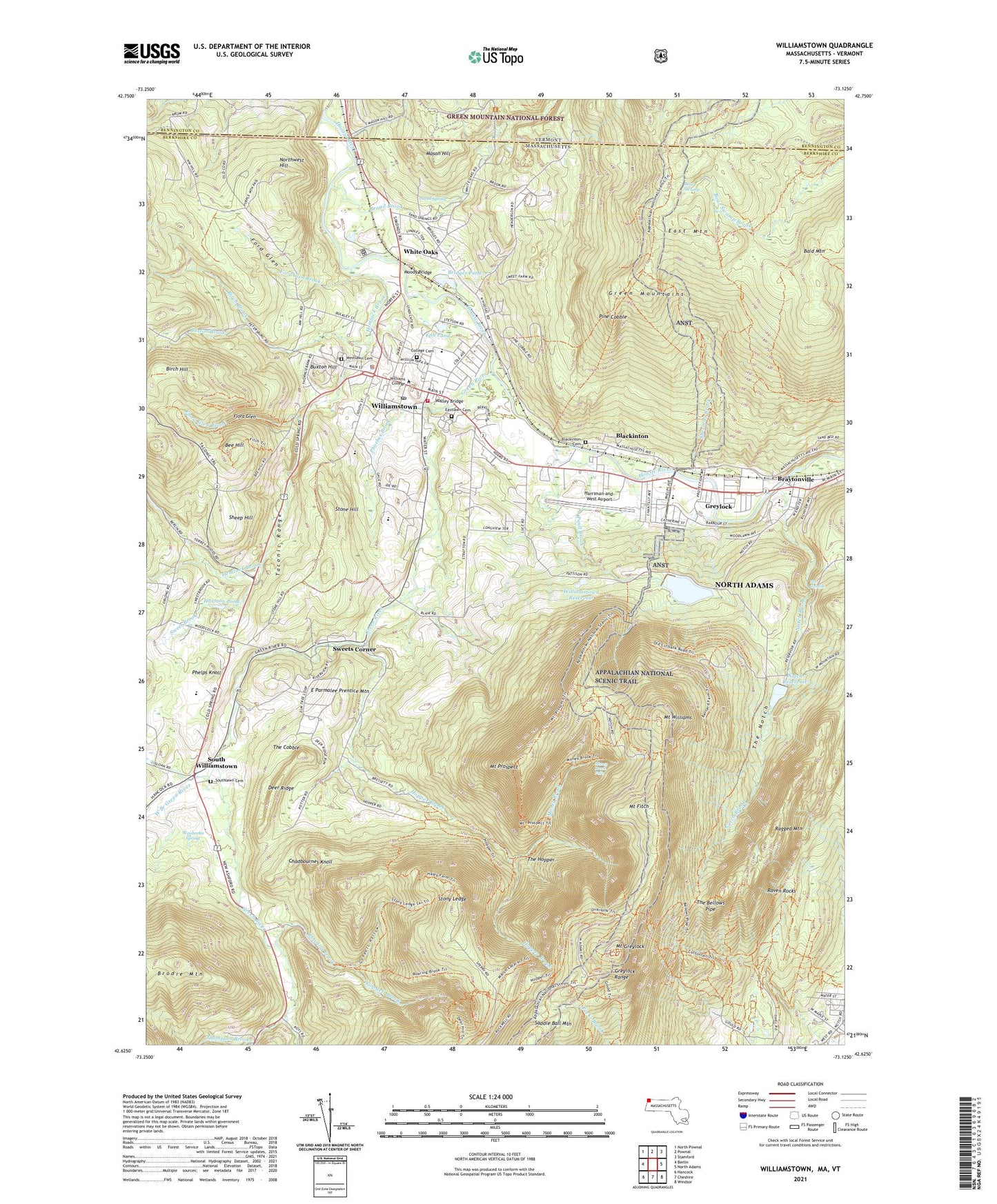
Williamstown Massachusetts US Topo Map
Couldn't load pickup availability
Also explore the Williamstown Forest Service Topo of this same quad for updated USFS data
2024 topographic map quadrangle Williamstown in the states of Massachusetts, Vermont. Scale: 1:24000. Based on the newly updated USGS 7.5' US Topo map series, this map is in the following counties: Berkshire, Bennington. The map contains contour data, water features, and other items you are used to seeing on USGS maps, but also has updated roads and other features. This is the next generation of topographic maps. Printed on high-quality waterproof paper with UV fade-resistant inks.
Quads adjacent to this one:
West: Berlin
North: Pownal
Northeast: Stamford
East: North Adams
Southeast: Windsor
South: Cheshire
Southwest: Hancock
Contains the following named places: Adams Memorial Theatre, Adams Nursing HOme, Bacons Farm, Bald Mountain, Bascom Lodge, Bear Swamp, Bee Hill, Bethel Pentecostal Church, Birch Brook, Birch Hill, Birch Hill Brook, Blackington Historic District, Blackinton, Blackinton Cemetery, Blair Hiking Area, Brayton Hill, Braytonville, Bridges Pond, Broad Brook, Broad Brook School, Bruce R Carlson Library, Buxton Brook, Buxton Gardens, Buxton Hill, Buxton School, Camp Muriel Flagg, Cascade Park, Chadbournes Knoll, Circle Trail, Clark Art Museum, Clarksburg State Forest, Cole Field, College Cemetery, Colonial Shopping Center, Community Bible Church, Congregational Church, David and Joyce Milne Public Library, Deer Hill Trail, Deer Ridge, Denison Park, E Parmalee Prentice Mountain, East Branch Green River, East Mountain, Eastlawn Cemetery, Elizabeth S Botsford Memorial Library, Eph Pond, Farm Museum, Field Park, First Baptist Church, First Congregational Church, First United Methodist Church, Flora Glen, Flora Glen Brook, Ford Glen, Ford Glen Brook, Fort Massachusetts, Fort W Hoosac, Goodell Brook, Goodell Hollow, Grand Union Shopping Center, Green River, Green River Farms, Greylock, Greylock Park, Greylock Range, Greylock School, Harmon Pond, Harper Center Senior Citizens Center, Harriman-and-West Airport, Hemlock Brook, Hemlock Brook Estates, Hopper Brook, Hopper Trail, Krigers Mill, Lindley Park, Linear Park, Mason Hill, Meadowvale, Mill Village Historic District, Money Brook, Money Brook Falls, Moody Bridge, Mount Fitch, Mount Greylock, Mount Greylock Christian School, Mount Greylock Regional High School, Mount Greylock Ski Club, Mount Hope Farm, Mount Hope Park, Mount Prospect, Mount Williams, Mount Williams Reservoir, Mount Williams Reservoir Dam, Norad Mill, Northwest Hill, Notch Brook, Notch Reservoir, Notch Reservoir Dam, Old Quaker Meeting House, Our Lady of the Incarnation Church, Overlook Trail, Paull Brook, Phelps Knoll, Phoebes Brook, Pine Cobble, Pine Cobble School, Ragged Mountain, Raven Rocks, Red Schoolhouse, Roaring Brook, Saint Johns Episcopal Church, Saint Patricks Roman Catholic Church, Saint Raphaels Roman Catholic Church, Sand Spring, Second Congregational Church, Sheep Hill, Sherman Brook, South Williamstown, Southlawn Cemetery, Sprague Number 1 Heliport, Sprague Number 2 Heliport, Steeles Corners, Sterling and Francine Clark Art Institute, Stone Hill, Stony Ledge, Stony Ledge Ski Trail, Sweet Brook, Sweet Brook Nursing Home, Sweets Corner, Taconic Golf Course, The Bellows Pipe, The Cascade, The Cobble, The Highcroft School, The Hopper, The Notch, The Spruces Mobile Home Park, Thiel Farm, Thompson Brook, Thompson Memorial Chapel, Thunderbolt Ski Trail, Town of Williamstown, Village Ambulance Service, Walley Bridge, War Memorial Beacon, Waubeeka Spring, Waubeeka Springs Golf Course, WCDC-TV (Adams), WCFM-FM (Williamstown), West Branch Green River, Westlawn Cemetery, Weston Field, White Oaks, Williams College, Williams College Libraries, Williams College Museum of Art, Williamstown, Williamstown Census Designated Place, Williamstown Elementary School, Williamstown Fire Department, Williamstown House of Local History, Williamstown Municipal Building, Williamstown Police Department, Williamstown Post Office, Williamstown Reservoir, Williamstown Reservoir Dam, YMCA, ZIP Code: 01267