MyTopo
Battle Creek Michigan US Topo Map
Couldn't load pickup availability
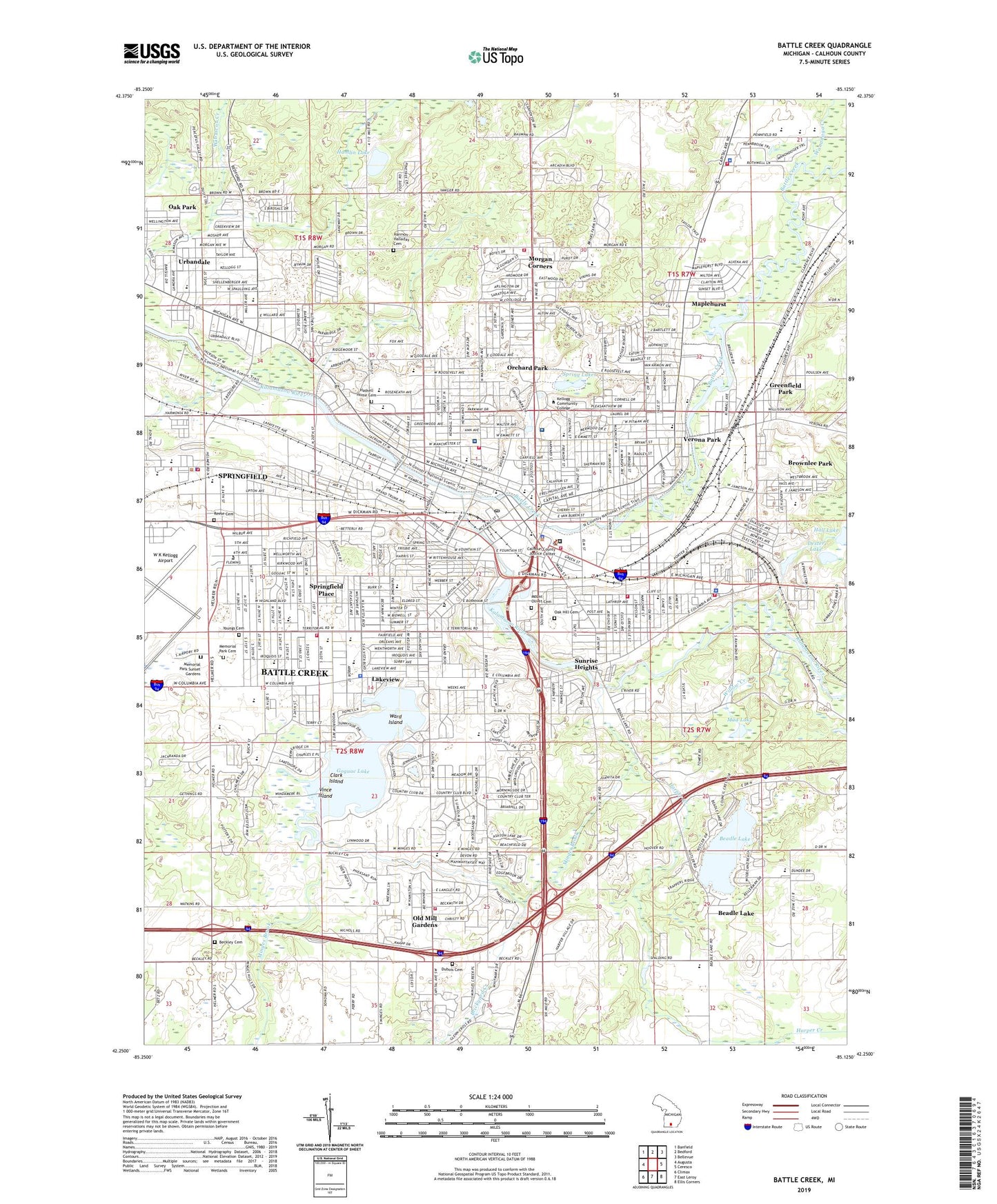
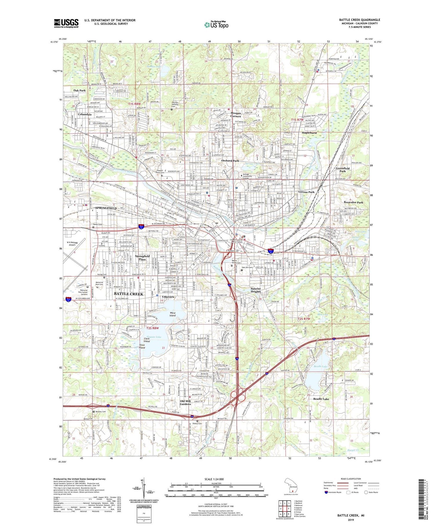
2023 topographic map quadrangle Battle Creek in the state of Michigan. Scale: 1:24000. Based on the newly updated USGS 7.5' US Topo map series, this map is in the following counties: Calhoun. The map contains contour data, water features, and other items you are used to seeing on USGS maps, but also has updated roads and other features. This is the next generation of topographic maps. Printed on high-quality waterproof paper with UV fade-resistant inks.
Quads adjacent to this one:
West: Augusta
Northwest: Banfield
North: Bedford
Northeast: Bellevue
East: Ceresco
Southeast: Ellis Corners
South: East Leroy
Southwest: Climax
This map covers the same area as the classic USGS quad with code o42085c2.
Contains the following named places: African Methodist Episcopal Church Historical Marker, Agnew Corners, Albion District United Methodist Church, Ann Kellogg School, Avonwood Village Mobile Home Park, Bailey Park, Baker Village Mobile Home Park, Barnes Park, Barnum Creek, Battle Creek, Battle Creek Academy, Battle Creek Bible Church, Battle Creek Chinese Baptist Church, Battle Creek Christian School, Battle Creek City Hall Historical Marker, Battle Creek Country Club, Battle Creek Fire Department Station 1, Battle Creek Fire Department Station 2, Battle Creek Fire Department Station 3, Battle Creek Fire Department Station 4, Battle Creek Fire Department Station 5, Battle Creek Fire Department Station 6, Battle Creek Hanmee Church, Battle Creek House Historical Marker, Battle Creek Number Four Fire Station Historical Marker, Battle Creek Police Department, Battle Creek Post Office, Battle Creek Post Office Historical Marker, Battle Creek Public Farm School, Battle Creek Rest Area, Battle Creek Sanitarium Historical Marker, Battle Creek Station, Beadle Lake, Beadle Lake School, Beadle Post Office, Beadle Station, Beckley Cemetery, Beckley Cemetery Historical Marker, Beckley School Historical Marker, Bedford Charter Township Fire Department Station 3, Bedford Hills Mobile Village, Birchwood United Methodist Church, Brickyard Creek, Bronson Battle Creek Hospital, Brownlee Park, Brownlee Park Census Designated Place, C W Post Historical Marker, Calhoun County Justice Center, Calhoun County Sheriff's Department Pennfield Station, Calhoun County Sheriff's Office, Calvary Chapel, Central Christian Church, Central High School, Cereal Bowl of America Historical Marker, Chapel Hill United Methodist Church, Christ Community Church, Church at Minges Hill, Church of Christ, Church of Jesus Christ of Latter Day Saints, Church of the Resurrection, City of Battle Creek, City of Springfield, Clark Island, Community Hospital, Cornerstone Community Church, Creek Valley Mobile Home Park, Crosscreek Christian School, Crosspoint Church, Del Shannon Historical Marker, Dexter Lake, Dubois Cemetery, Dudley School, Dunlap Middle School, Emmett Township Department of Public Safety, Emmett Township Department of Public Safety Fire Station, Emmett Township Department of Public Safety Police Department, Endeavor Charter Academy, Erastus Hussey Stationmaster Historical Marker, Fairfax Community Baptist Church, Faith Baptist Church, Family Altar Chapel, Fell Park, Fieldstone Center, First Assembly of God Church, First Baptist Church, First Baptist Church Historical Marker, First Christian Church, First Church of Christ Scientist, First Church of the Nazarene, First Congregational Church, First Evangelical Presbyterian Church, First Pentecostal Church, First Presbyterian Church, First Salem Baptist Church, First United Methodist Church, First Wesleyan Church, Franklin School, Fremont School, Fruin Corners, Goguac Lake, Greenfield Park, Hall Lake, Hamlin Lake, Harmon Halladay Cemetery, Harper Creek, Harper Creek Baptist Church, Harper Creek High School, Harper Creek Middle School, Hart-Dole-Inouye Federal Center, Haskell Home Cemetery, Heartland Health Care Center, Irving Park, James and Ellen White Historical Marker, Kellogg Community College, Kellogg Company Historical Marker, Kellogg Junior High School, Kimball House Museum, Kimball House Museum Historical Marker, Kimball Sanitorium, Kingman Museum, Kolb Park, Lakeview, Lakeview High School, Lakeview School, Lakeview Square Mall, LaMora Park Elementary School, Laurels of Bedford Nursing Home, Leila Arboretum, Leila Hospital Helistop, LifeCare Ambulance, Lincoln School, Log Schoolhouse Historical Marker, Lower Mill Pond, Maple United Methodist Church, Maplehurst, McCrae Park, McKinley School, Memorial Park Cemetery, Memorial Park Sunset Gardens, Methodism in Battle Creek Historical Marker, Michigan Central Depot Historical Marker, Michigan State Police Department, Minges Brook, Minges Brook School, Moores Corners, Morgan Corners, Mount Olivet Cemetery, Mud Lake, Newman School, Northwestern Middle School, Nursing Clinic of Battle Creek, Oak Forest Mobile Home Park, Oak Hill Cemetery, Old Mill Gardens, Orchard Park, Outland United Methodist Church, Pennfield High School, Pennfield School, Pennfield Township Fire Department Station 1, Percy Jones General Hospital Historical Marker, Piper Park, Post Park, Post School, Postum Cereal Company Factory Historical Marker, Postum Cereal Company Historical Marker, Prairieview School, Purdy Elementary School, Raymound School, Reese Cemetery, Riverside Country Club, Riverside School, Romans Drain, Roosevelt School, Runaway Historical Marker, Saint James Church of God in Christ, Saint John Lutheran Church, Saint Joseph School, Saint Mark's Lutheran Church, Saint Paul Evangelical Church, Saint Peter Lutheran Church, Saint Philip Middle and High School, Saint Thomas Episcopal Church, Saint Thomas Episcopal Church Historical Marker, School Number 2, Second Baptist Church Historical Marker, Seirn B Cole House Historical Marker, Seventh-day Adventists Historical Marker, South Hill Academy, South West Junior High School, Southside Bible Church, Southwest Regional Rehabilitation Hospital, Spring Lakes, Springfield, Springfield Fire Department, Springfield Middle School, Springfield Place, Springfield Police Department, Springfield School, Sunrise Heights, Temple Beth El, Territorial School, Thunderbird Mobile Village, Triangle Mobile Home Park, Trinity United Methodist Church, Unity Missionary Baptist Church, Urbandale, Urbandale School, Valley View School, Verona Elementary School, Verona Park, Victory Life Church, Vince Island, W K Kellogg Airport, W K Kellogg Historical Marker, Wanadoga Creek, Ward Building Site Historical Marker, Ward Island, Ward Mill Site Historical Marker, Washington School, Watsh Field, WBCK-AM (Battle Creek), WBXX-FM (Battle Creek), WELL-AM (Battle Creek), Westlake Presbyterian Church, Westlake School, Willard Park, Willard Public Library, Willow Creek, Wilson School, WOLY-AM (Battle Creek), Woodrow Junior High School, Working for Humanity Historical Marker, Youngs Cemetery, ZIP Codes: 49015, 49037