MyTopo
Davison Michigan US Topo Map
Couldn't load pickup availability
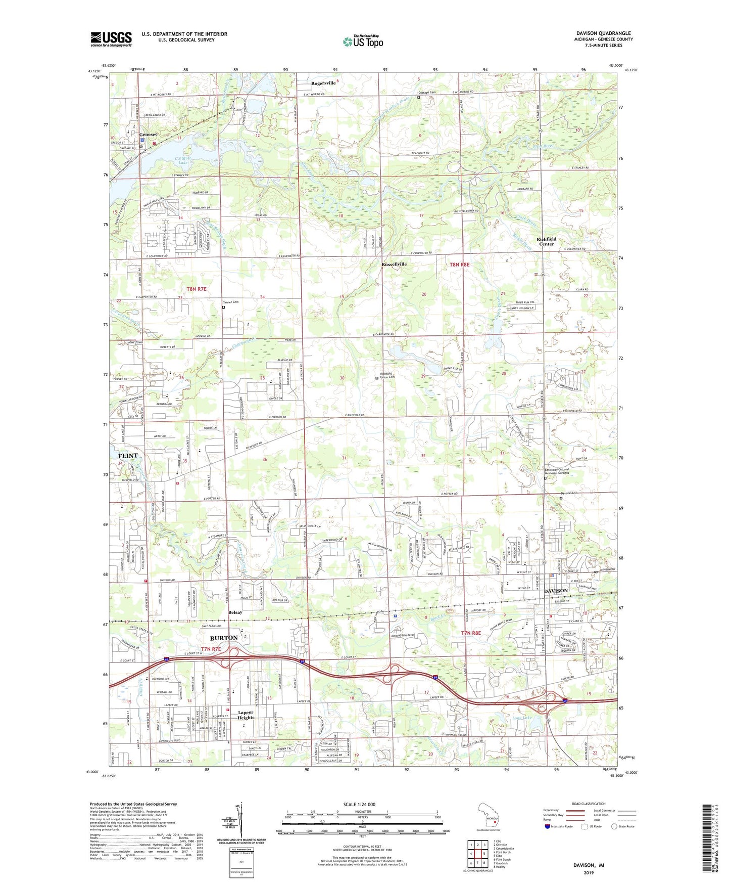
2023 topographic map quadrangle Davison in the state of Michigan. Scale: 1:24000. Based on the newly updated USGS 7.5' US Topo map series, this map is in the following counties: Genesee. The map contains contour data, water features, and other items you are used to seeing on USGS maps, but also has updated roads and other features. This is the next generation of topographic maps. Printed on high-quality waterproof paper with UV fade-resistant inks.
Quads adjacent to this one:
West: Flint North
Northwest: Clio
North: Otisville
Northeast: Columbiaville
East: Elba
Southeast: Hadley
South: Goodrich
Southwest: Flint South
This map covers the same area as the classic USGS quad with code o43083a5.
Contains the following named places: Athelone Williams Memorial Airport, Austin Drain, Barhitte School, Bear Swamp Ditch, Belsay, Belsay School, Belsay Station, Belsey Post Office, Bentley High School, Bentley Wesleyan Church, Bethel Assembly of God Church, Bird Drain, Black Creek, Blessed Sacrament School, Brier Drain, Brookwood Golf Course, Burton Fire Department Station 2, Burton Fire Department Station 3, Butternut Creek, C S Mott Lake, Calvary Baptist Church, Calvert Park Community Church, Cartwright School, Central Elementary School, City of Davison, City of Hope Church, Clark Drain, Cochran Drain, Community of Christ-Eastside, Continental Estates Mobile Home Park, Continental North Mobile Home Park, Cottage Cemetery, Daly Junior High School, Davison, Davison Area Historical Museum, Davison Area Library, Davison Cemetery, Davison Church of Christ, Davison City Hall, Davison Community Church, Davison Country Club, Davison Free Methodist Church, Davison High School, Davison Middle School, Davison Missionary Church, Davison Police Department, Davison Post Office, Davison Regional Park, Davison Richfield Fire Department, Davison Roadside County Park, Davison School, Davison Station, Davison Township Police Department, Davison United Methodist Church, Dowdall School, Eastwood Colonial Memorial Gardens, Emmanuel United Methodist Church, Fiedler School, First Assemby of God Church, First Baptist Church of Davison, For-mar Nature Preserve, Friendship Free Will Baptist Church, Generation of Destiny Ministry, Genesee, Genesee High School, Genesee Post Office, Genesee Recreation Area, Genesee Station, Genesee Township Fire Department Station 1, Genesee Township Fire Department Station 2, Genesee Township Police Department, Genesee United Methodist Church, Good Shepherd Lutheran Church, Grace Bible Church, Grace Worship Center, Haas School, Hahn Intermediate School, Harris Memorial Church, Heritage United Church of Christ, Hill School, Holy Rosary High School, Johnson School, Kearsley High School, Kingdom Hall of Jehovah's Witnesses, Lapeer Heights, Lions Gate Golf and Country Club, Long Lake, McLaren Community Medical Center, Miracle Twin Drive-In, Missionary Church of Michigan, Northeast Post Office, Paro School, Powers Cullen Drain, Richfield Center, Richfield Church of the Nazarene, Richfield County Park, Richfield Township Police Department Davison, Richfield Union Cemetery, Richfield United Methodist Church, Riegle Drain, Rogersville, Rogersville Post Office, Russellville, Russellville Community Wesleyan Church, Saint Andrews Presbyterian Church, Saint John Catholic Church, Saint Johns School, Shawn Baptist Church, Siple School, Tanner Cemetery, Tanner School, Thompson School, Township of Davison, Township of Richfield, Trinity Lutheran Church, Vassar Park Church, Weston School, Zufelt Drain, ZIP Codes: 48423, 48437, 48506, 48509