MyTopo
Dimondale Michigan US Topo Map
Couldn't load pickup availability
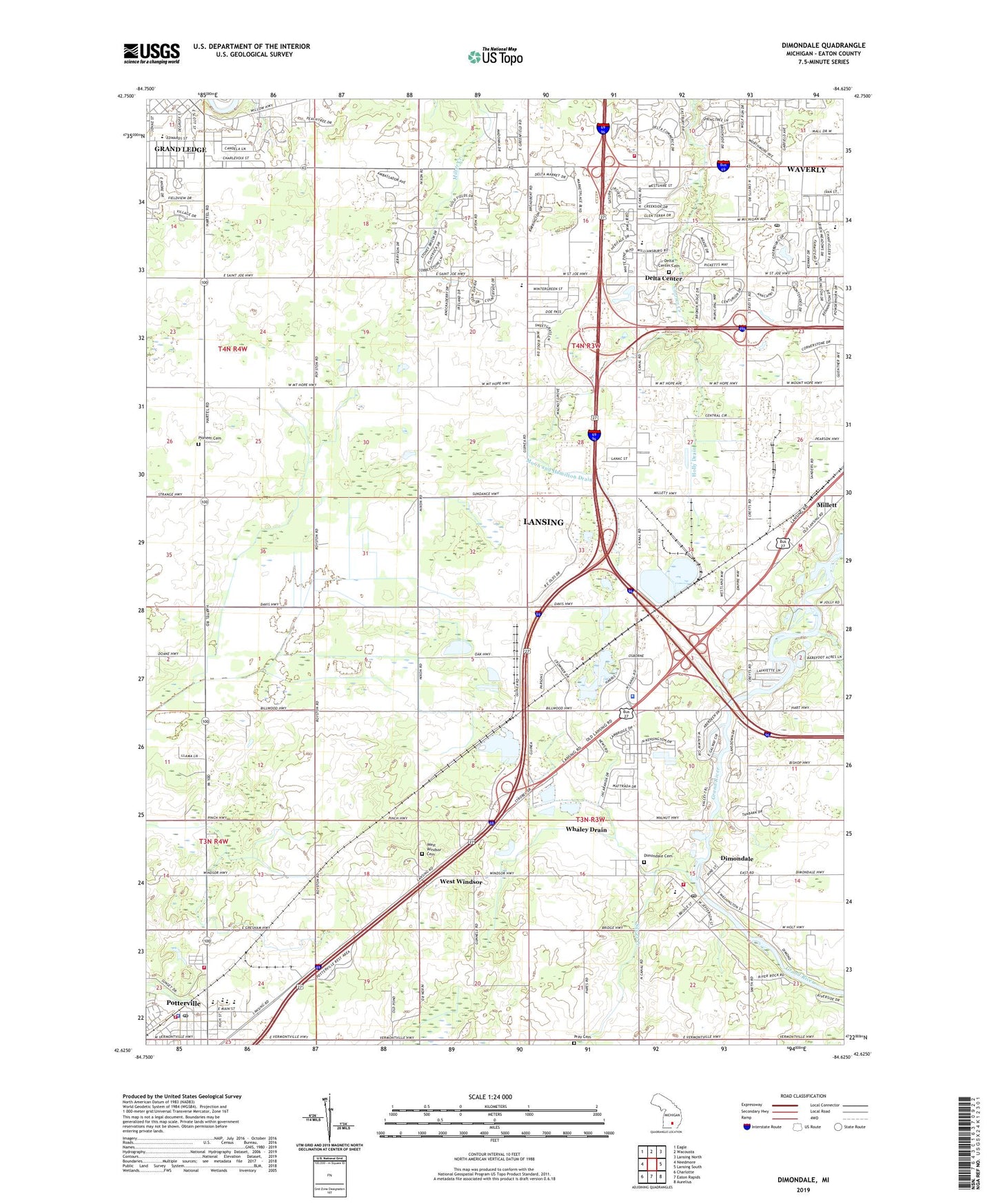
2019 topographic map quadrangle Dimondale in the state of Michigan. Scale: 1:24000. Based on the newly updated USGS 7.5' US Topo map series, this map is in the following counties: Eaton. The map contains contour data, water features, and other items you are used to seeing on USGS maps, but also has updated roads and other features. This is the next generation of topographic maps. Printed on high-quality waterproof paper with UV fade-resistant inks.
Quads adjacent to this one:
West: Needmore
Northwest: Eagle
North: Wacousta
Northeast: Lansing North
East: Lansing South
Southeast: Aurelius
South: Eaton Rapids
Southwest: Charlotte
Contains the following named places: Benton Township Fire Department, Benton Township Library, Bright Hope Bible Church, Carman Drain, Century Park Mobile Home Park, Charter Township of Delta, Charter Township of Windsor, City of Potterville, Covenant Christian Reformed Church, Delta Carrier Annex Post Office, Delta Center, Delta Center Cemetery, Delta Center Methodist Church Historical Marker, Delta Center School, Delta Charter Township Historical Marker, Delta Medical Center, Delta Township Fire Department Station 1 Headquarters, Delta Township Fire Department Station 2 Storage, Delta Township Historical Marker, Diamondale Elementary School, Dimondale, Dimondale Cemetery, Dimondale Elementary School, Dimondale Post Office, Dimondale Station, Dimondale United Methodist Church, Erickson Park, First Presbyterian Church, First Presbyterian Church Historical Marker, Grand Ledge Academy, Grand Ledge Baptist Church, Grand Ledge Country Club, Grand Ledge Health Park, Holly Drain, Immanuel Lutheran Church, Independence Commons Mobile Home Park, Lake Delta, Lansing Mall, Michigan State Police District 1 Headquarters and Lansing Post 11, Mid-Michigan Family Medical Clinic, Millet Bible Baptist Church, Moon and Hamilton Drain, Mount Hope Church, Munton Drain, Neff School, Palmiter and Phelps Drain, Pioneer Cemetery, Potterville, Potterville Church of the Nazarene, Potterville High School, Potterville Police Department, Potterville Post Office, Potterville Rest Area, Potterville Station, Potterville United Methodist Church, Potterville United Methodist Church Historical Marker, Pray Cemetery, Saint Michael School, Saint Michaels Catholic Church, Sawdon Junior High School, Sharp Drain, Silver Creek, Thornapple and Old Maid Drain, Trinity United Methodist Church, Underhill Store Historical Marker, Valley Springs Mobile Home Park, Village of Dimondale, Waverly Census Designated Place, West Lansing Church of Christ, West Windsor, West Windsor Cemetery, West Windsor Post Office, West Windsor United Brethren Church, Westland Park, Whaley Drain, Winans School, Windsor Estates Mobile Home Park, Windsor Township Emergency Services, Windsor Township Fire and Emergency Services, Windsor Township Library, Woldumar Nature Center, ZIP Codes: 48821, 48876, 48917