MyTopo
Eaton Rapids Michigan US Topo Map
Couldn't load pickup availability
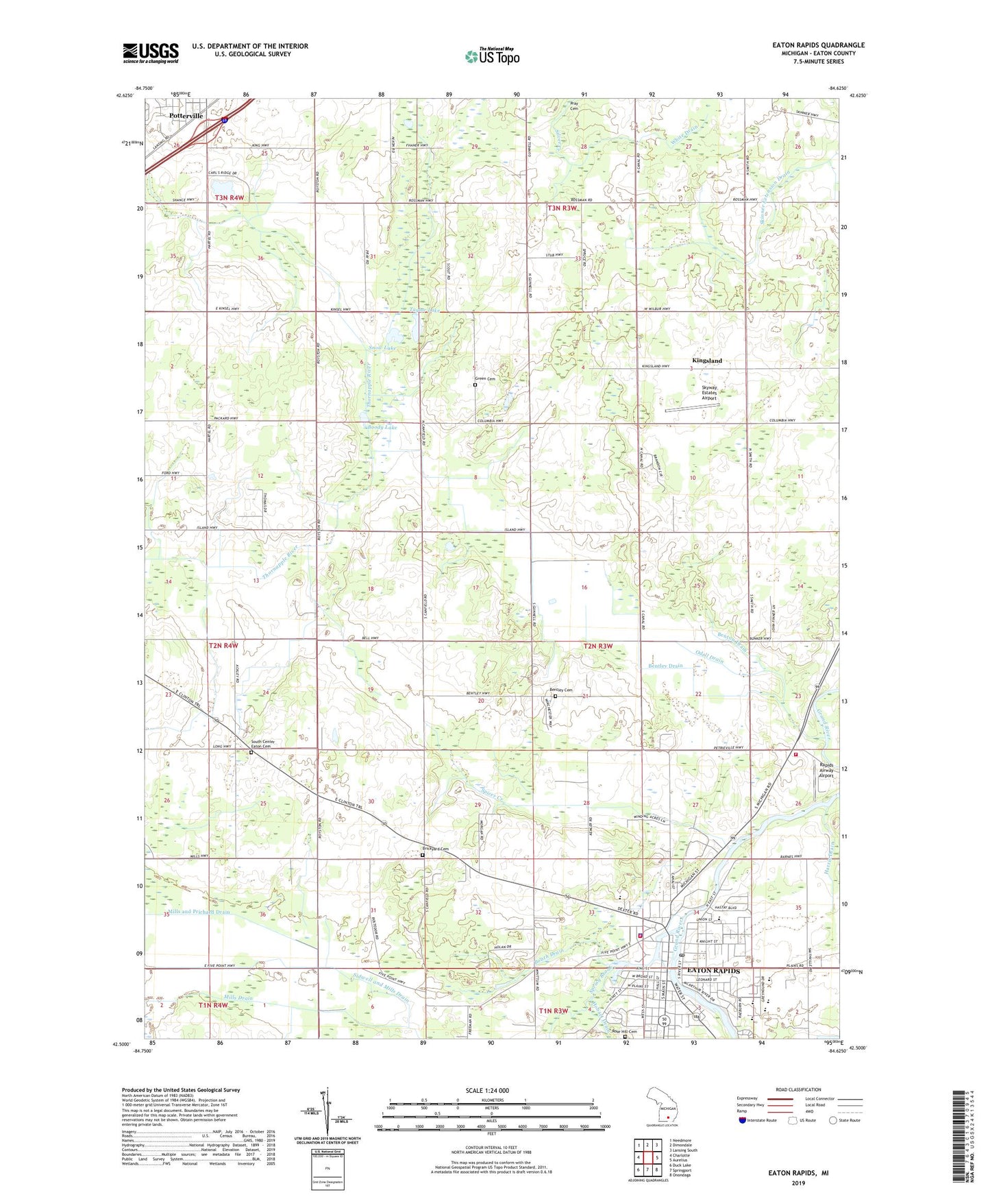
2023 topographic map quadrangle Eaton Rapids in the state of Michigan. Scale: 1:24000. Based on the newly updated USGS 7.5' US Topo map series, this map is in the following counties: Eaton. The map contains contour data, water features, and other items you are used to seeing on USGS maps, but also has updated roads and other features. This is the next generation of topographic maps. Printed on high-quality waterproof paper with UV fade-resistant inks.
Quads adjacent to this one:
West: Charlotte
Northwest: Needmore
North: Dimondale
Northeast: Lansing South
East: Aurelius
Southeast: Onondaga
South: Springport
Southwest: Duck Lake
This map covers the same area as the classic USGS quad with code o42084e6.
Contains the following named places: Austin Blair Historical Marker, Bentley Cemetery, Bentley Drain, Benton Drain, Bonnie View Golf Course, Boody Lake, Booth Drain, Brickyard Cemetery, Briggs Park, Burkhead Drain, Calvary Evangelical Lutheran Church, Calvary Grace Church, Childs Drain, Church of the Nazarene, City of Eaton Rapids, Community Christian Church, Crandall Drain, East and Bodell Drain, Eaton Pines Village Mobile Home Park, Eaton Rapids, Eaton Rapids Assembly of God Church, Eaton Rapids City Fire Department, Eaton Rapids High School, Eaton Rapids Middle School, Eaton Rapids Police Department, Eaton Rapids Post Office, Eaton Rapids Station, Eaton Rapids Township Fire Department, First Congregational Church, First United Methodist Church, Garvey Drain, Green Cemetery, Greyhound Intermediate School, Gruesbeck Drain, Hall Street Park, Harris Drain, Island City Baptist Chapel, Island Park, Island Park Historical Marker, J B Bradley Park, King Drain, King Lake, Kingsland, Kingsland Post Office, Kingsland Station, Lockwood Elementary School, McArthur Park, Memorial Park, Milbourn Allen and Crane Drain, Miller Dairy Farm Number One Historical Marker, Mills and Prichard Drain, Mills Drain, Northwestern School, Odell Drain, Owen Drain, Parma and Sheridan Number Seven School Historical Marker, Peters Church, Playground of Dreams, Rapids Airway Airport, Red Ribbon Hall Historical Marker, Saint Peter's Catholic Church, Saint Peter's Catholic School, Saratoga of the West Historical Marker, Sidwell and Mills Drain, Skyway Estates Airport, Smithville Dam, Snow Lake, South Center Eaton Cemetery, Spicer Creek, Spring Brook, Taylor Lake, Thornapple Drain, Township of Eaton Rapids, Union Street School, White Drain, ZIP Code: 48827