MyTopo
Charlotte Michigan US Topo Map
Couldn't load pickup availability
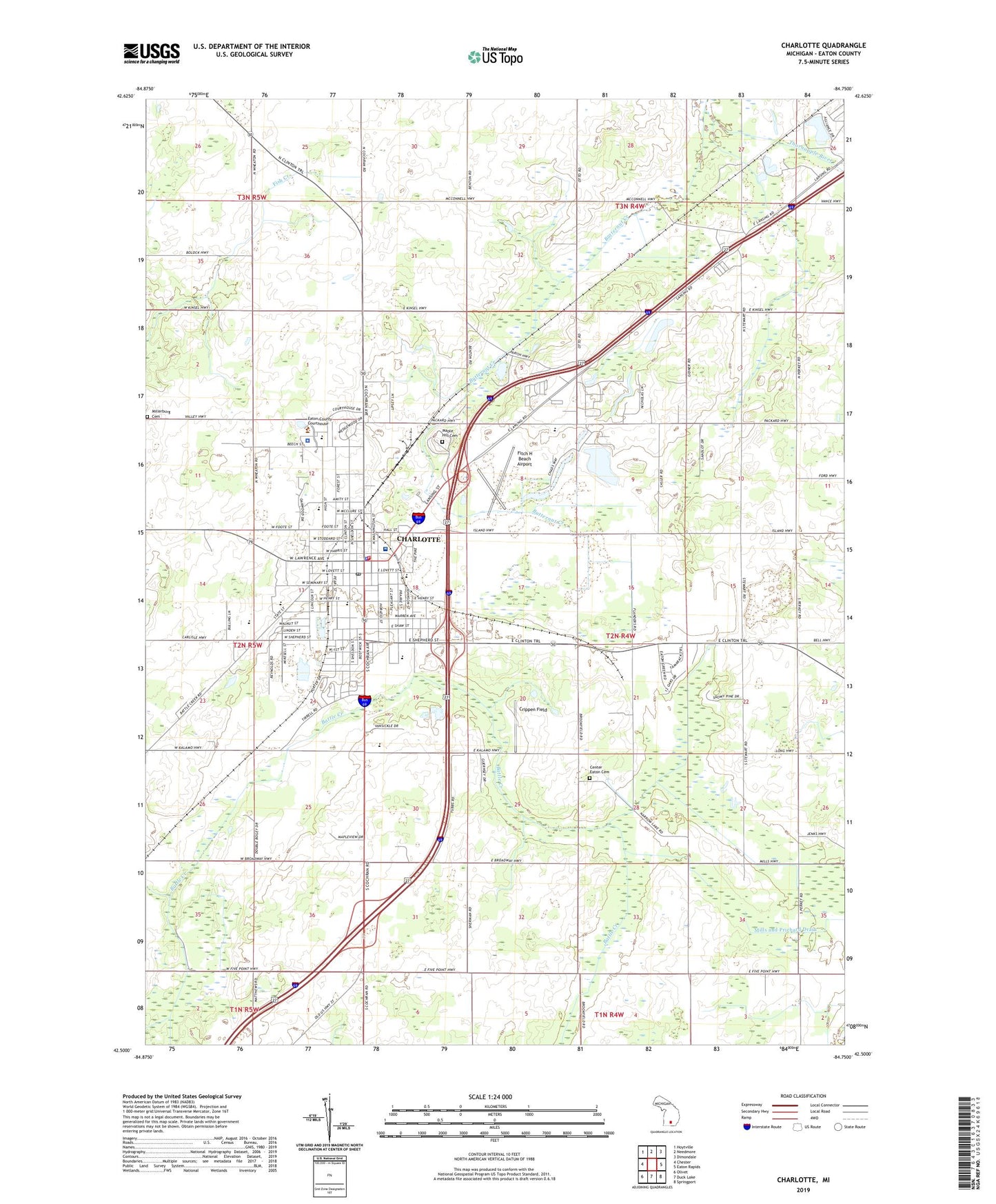
2023 topographic map quadrangle Charlotte in the state of Michigan. Scale: 1:24000. Based on the newly updated USGS 7.5' US Topo map series, this map is in the following counties: Eaton. The map contains contour data, water features, and other items you are used to seeing on USGS maps, but also has updated roads and other features. This is the next generation of topographic maps. Printed on high-quality waterproof paper with UV fade-resistant inks.
Quads adjacent to this one:
West: Chester
Northwest: Hoytville
North: Needmore
Northeast: Dimondale
East: Eaton Rapids
Southeast: Springport
South: Duck Lake
Southwest: Olivet
This map covers the same area as the classic USGS quad with code o42084e7.
Contains the following named places: 1845 Eaton County Courthouse Historical Marker, 48813, Alliance Lake Softball Park, Bennett Park, Bush School, Butternut Creek, Calvary Baptist Church, Center Easton Church, Center Eaton Cemetery, Center Eaton United Methodist Church Historical Marker, Charlotte, Charlotte Aquatic Center, Charlotte City Hall, Charlotte Community Library, Charlotte Country Club, Charlotte Fire Department Downtown Station, Charlotte High School, Charlotte Medical Group, Charlotte Middle School, Charlotte Penecostal Church, Charlotte Police Department, Charlotte Post Office, Charlotte Station, Christian Reformed Church, Church of Christ, Church of Faith in God, Church of Jesus Christ of Latter Day Saints, Church of the Nazarene, City of Charlotte, Community of Christ Church, Crippen Field, Crossroads Church of the United Brethren, Dean Park, Densmore Perkins Fish Creek Drain, Easton School, Eaton Center Church, Eaton County, Eaton County Christian Church, Eaton County Courthouse, Eaton County Courthouse Square Historical Marker, Eaton County Fairgrounds, Eaton County Historical Marker, Eaton County Sheriff's Office, Evangelical Christian Church, Fairview School, First Baptist Church, First Congregational Church, First Congregational Church of Charlotte Historical Marker, First Lutheran Church, First Lutheran School, Fitch H. Beach Airport, Five Corners Church, Five Points Corner, Free Methodist Church, Galewood School, Hi-Way Mobile Haven, Joseph and Mary Hall House Historical Marker, Lawrence Avenue United Methodist Church, Lawrence Manor Mobile Home Park, Lincoln Park, Maple Hill Cemetery, Maple Knoll Mobile Home Park, Maurer School, McClintic School, McConnell School, Meadows Mobile Home Park, Miller School, Millerburg Cemetery, Morse School, Munson School, New Hope Community Church, Oak Park, Parkview Elementary School, Peace Lutheran Church, Perkey School, Quantrell School, Saint John's Episcopal Church, Saint Mary's Catholic Church, Saint Mary's School, Seventh-Day Adventist Church, Seventh-Day Adventist School, South Cochran Church of God, Southridge Park, Southworth School, Sparrow Eaton Hospital, Township of Eaton, Twin Brook Golf Club, Veterans Memorial Park, Washington School, Weymouth School, Wheaton Road Church, Wheaton School, WNLF-AM (Charlotte)