MyTopo
Fergus Falls Minnesota US Topo Map
Couldn't load pickup availability
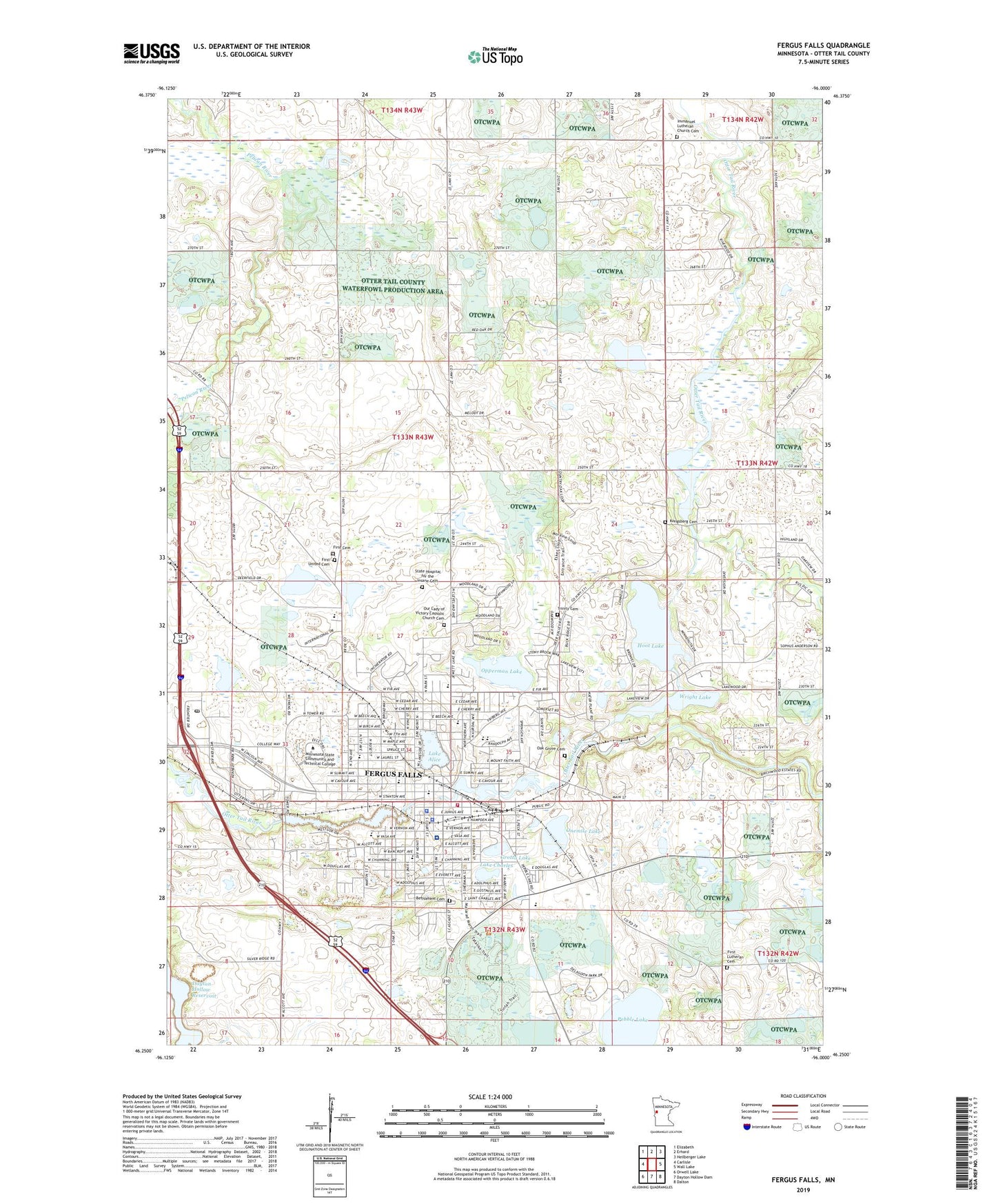
2019 topographic map quadrangle Fergus Falls in the state of Minnesota. Scale: 1:24000. Based on the newly updated USGS 7.5' US Topo map series, this map is in the following counties: Otter Tail. The map contains contour data, water features, and other items you are used to seeing on USGS maps, but also has updated roads and other features. This is the next generation of topographic maps. Printed on high-quality waterproof paper with UV fade-resistant inks.
Quads adjacent to this one:
West: Carlisle
Northwest: Elizabeth
North: Erhard
Northeast: Heilberger Lake
East: Wall Lake
Southeast: Dalton
South: Dayton Hollow Dam
Southwest: Orwell Lake
Contains the following named places: Adams Park, Adams School, Bethlehem Cemetery, Bigwood Events Center, Broken Down Dam Park, Central-Wright Dam, Channing Recreational Area, City Hall Park, City of Fergus Falls, Cleveland School, Community Behavioral Health Hospital Fergus Falls, Delagoon Park, Eisenhower School, Fergus Falls, Fergus Falls City Hall, Fergus Falls Fire Department, Fergus Falls Medical Group Building, Fergus Falls Middle School, Fergus Falls Police Department, Fergus Falls Post Office, Fergus Falls Public Library, Fergus Falls State Hospital, Fergus Falls State Hospital Cemetery, Fergus Falls State Wildlife Management Area, First Lutheran Cemetery, First Lutheran Church, First Lutheran North Cemetery, First United Church of Christ Cemetery, George B Wright Park, Godel Park, Good Shepherd Lutheran Brethren Church, Grace United Methodist Church, Green Acres Mobile Park, Grotto Lake, Hedemarken Lutheran Church, Hillcrest Academy, Hoot Lake, Hope Evangelical Lutheran Church, I-94 Speedway, Immanuel Church, Immanuel Lutheran Church Cemetery, Jefferson School, KBRF-AM (Fergus Falls), Kennedy Park, Kessel Group Home, Kingdom Hall of Jehovah's Witnesses, Kongsberg Cemetery, Lake Alice, Lake Alice Park, Lake Charles, Lake Park Wild Rice School, Lake Region Healthcare Hospital, Lakeview Estates, Law Enforcement Center, Lincoln School, Lutheran Brethern Homes, Madison School, McKinley School, Mill Park Post Office, Minnesota State Community and Technical College Fergus Falls Campus, Minnesota Veterans' Homes Fergus Falls, Morning Son Christian School, N P Park, North Broadway Park, Northeast Park, Oak Grove Cemetery, Old Smokey Ski Hill Park, Onemile Lake, Opperman Lake, Otter Tail County Courthouse, Otter Tail County Fairgrounds, Otter Tail County Historical Society Museum, Otter Tail County Jail, Otter Tail County Sheriff's Office, Otter Tail River Reservoir, Our Lady of Victory Church, Our Lady of Victory School, Pebble Lake, Pioneer Home, Pisgah Dam, Prairie Wetlalnds Learning Center, River Bluff Estates, Riverfront Square, Riverside Park, Riverside Waterfowl Sanctuary, Robert Hannah Recreational Area, Roosevelt Park, Roosevelt Park High School, Saint James Episcopal Church, Saint Ottos Catholic Cemetery, Salvation Army Church, School Number 208, School Number 28, School Number 80, School Number 92, Seventh-Day Adventist Church, T H Johnson Athletic Park, Township of Fergus Falls, Trinity Cemetery, Trinity Lutheran Church, Unitarian Church, Van Dyk Park, Veterans Administration Clinic, Veterans Memorial Park, West Ridge Medical Center, Westridge Mall, Whitford Recreational Area, Woodland Baptist Church, Wright Lake, Zion Lutheran Church, ZIP Code: 56537