MyTopo
La Crescent Minnesota US Topo Map
Couldn't load pickup availability
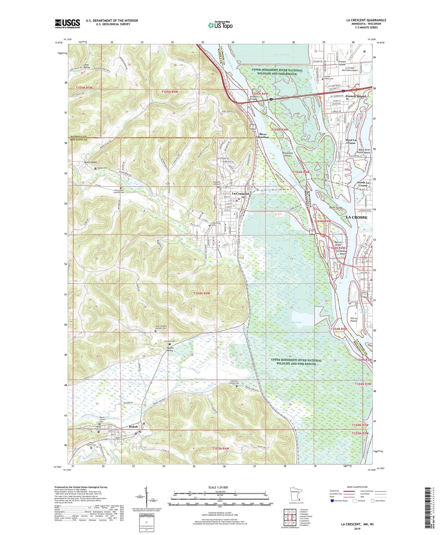
2022 topographic map quadrangle La Crescent in the states of Minnesota, Wisconsin. Scale: 1:24000. Based on the newly updated USGS 7.5' US Topo map series, this map is in the following counties: Houston, La Crosse, Winona. The map contains contour data, water features, and other items you are used to seeing on USGS maps, but also has updated roads and other features. This is the next generation of topographic maps. Printed on high-quality waterproof paper with UV fade-resistant inks.
Quads adjacent to this one:
West: Mound Prairie
Northwest: Pickwick
North: Holmen
Northeast: Onalaska
East: La Crosse
Southeast: Stoddard
South: Brownsville
Southwest: Caledonia
Contains the following named places: Abnet Field, Barron Island, Black River, Black River Public Beach, Blue Lake, Broken Arrow Slough, Burns Valley, Butterfield Creek, Campbell Fire Department, Campbell Police Department, Church of the Crucifixion, Church of the Crucifixion Elementary School, City of Hokah, City of La Crescent, Community Church of Hokah, Como Falls Park, Convent Cemetery, Crossfire Ministries, Crucifixion Cemetery, Dresbach Bridge, Dresbach Travel Information Center, E R Barron Building, East Channel, First Evangelical Lutheran Church, Franciscan Skemp Health Care Center, Freight House, French Island, French Island Cemetery, French Island Census Designated Place, French Island Generating Plant, French Lake, French Slough, Gantert Building, Gundersen Tri - State Ambulance, Gunderson Lutheran La Crescent Clinic, Hills Mobile Home Park, Hoffman Family Cemetery, Hokah, Hokah City Park, Hokah Police Department, Hokah Post Office, Hokah Public Library, Hokah United Methodist Church, Hokah Volunteer Fire Department, Houska Park, Island Park Baptist Church, Isle La Plume, James Bennet Group Structure Dam, John S Harris Park, Kingdom Hall of Jehovahs Witnesses, Kistler Mobile Home Park, Kistler Park, KQEG-FM (La Crescent), KXLC-FM (La Crescent), La Crescent, La Crescent City Hall, La Crescent Elementary School, La Crescent Evangelical Free Church, La Crescent Fire Department, La Crescent Health Care Center, La Crescent Police Department, La Crescent Post Office, La Crescent Public Library, La Crescent Senior High School, La Crescent United Methodist Church, La Crosse Airport Fire Department, La Crosse Airport Police Department, La Crosse Civic Center, La Crosse County Jail, La Crosse County Sheriff's Department, La Crosse Fire Department Station 1, La Crosse Outlet Mall Shopping Center, La Crosse River, La Crosse Tribune Library, La Plume Slough, Legion Ball Field, Lock and Dam 7, Lock and Dam Number 7, Minnesota Island, Minnesotas Fashionable Tour Historical Marker, Mons Anderson House, Mosher Veterans Home, Mount Calvary Cemetery, Mount Hope Cemetery, Olivet Lutheran Church, Pettibone Beach, Pettibone Park, Pfeffer Valley, Pine Creek, Pine Creek Catholic Cemetery, Pine Creek Golf Course, Pool 7, Powell Place, Prince of Peace Lutheran Church, Prospect Hill Cemetery, Richmond Bay, River Junction, Riverside Park, Root River, Round Lake, Saint Joseph's Catholic Cemetery, Saint Peter Elementary School, Saint Peter's Church, Scientific College of Beauty and Barbering, Shepardson's Park, Skipper Buds Marina, Smith Slough, Summit Environmental School, Target Lake, Taylor Island, Thompson Creek, Thunderbird Mobile Home Park, Toledo Cemetery, Township of Dresbach, Township of Hokah, Township of La Crescent, Unitarian Universalist Fellowship Church, Upper French Island School, Upper Midwest Environmental Sciences Center, Valley South Park, Van Lin Orchards, Veteran's Park, Village Terrace, Waterworks Building, West Channel, West Family Cemetery, West La Crosse, Wisconsin Regional Arts Center, Zion Evangelical Lutheran Church, ZIP Code: 55947