MyTopo
Holmen Wisconsin US Topo Map
Couldn't load pickup availability
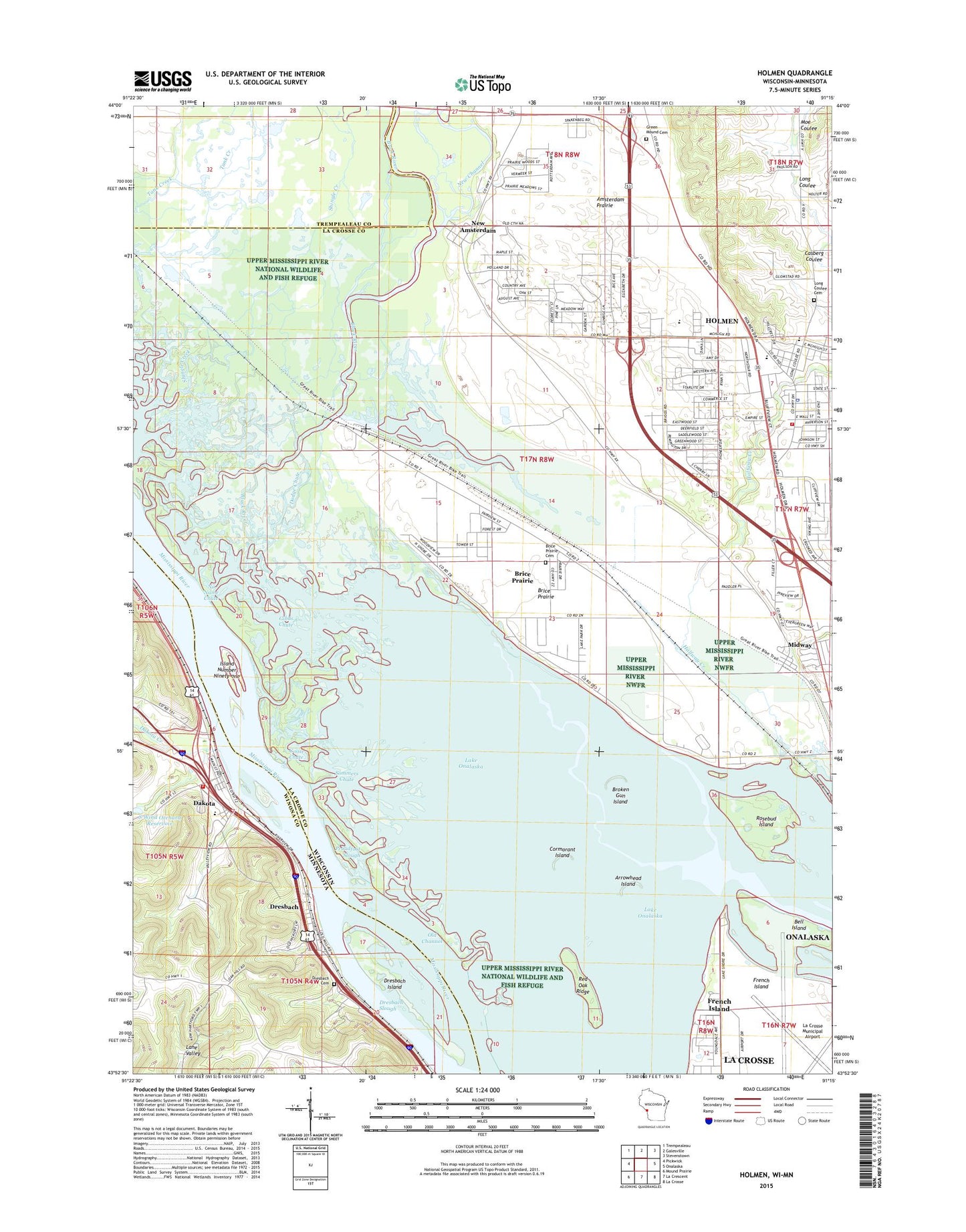
2022 topographic map quadrangle Holmen in the states of Wisconsin, Minnesota. Scale: 1:24000. Based on the newly updated USGS 7.5' US Topo map series, this map is in the following counties: La Crosse, Winona, Trempealeau. The map contains contour data, water features, and other items you are used to seeing on USGS maps, but also has updated roads and other features. This is the next generation of topographic maps. Printed on high-quality waterproof paper with UV fade-resistant inks.
Quads adjacent to this one:
West: Pickwick
Northwest: Trempealeau
North: Galesville
Northeast: Stevenstown
East: Onalaska
Southeast: La Crosse
South: La Crescent
Southwest: Mound Prairie
This map covers the same area as the classic USGS quad with code o43091h3.
Contains the following named places: Academy on the Prairie, Amsterdam Prairie, Arrowhead Island, Asbury Cemetery, Bell Island, Brice Prairie, Brice Prairie Census Designated Place, Brice Prairie EMS and Rescue, Broken Gun Island, City of Dakota, Cormorant Island, Dakota, Dakota City Hall, Dakota Creek, Dakota Elementary School, Dakota Fire and Rescue Department, Dakota Post Office, Dodge Chute, Dresbach, Dresbach Cemetery, Dresbach Census Designated Place, Dresbach Island, Dresbach Post Office, Dresbach Slough, Evergreen Elementary School, Gibbs Chute, Goose Chute, Grace Lutheran Church, Green Mound Cemetery, Halfway Creek, Hammond Chute, Holmen, Holmen Area Fire Department, Holmen High School, Holmen Middle School, Holmen Municipal Wastewater Treatment Plant, Holmen Police Department, Holmen Post Office, Holmen Square Shopping Center, Holmen Village Hall, Holy Cross Church, Island Number Ninety-one, La Crosse Regional Airport, Lake Onalaska, Lakeview, Long Coulee Cemetery, Long Coulee Park, Louis Nelson County Park, Lower Brice Prairie School, Midway, Midway Railroad Prairie State Natural Area, Midway School, Moe Coulee, New Amsterdam, New Channel, No Name Chute, Oak Grove Elementary School, Old Channel, Proudfoot Slough, Red Oak Ridge, Riverside United Methodist Church, Rosebud Island, Shingle Creek, Sommers Chute, South Wind Orchard Dam, South Wind Orchard Reservoir, Sunset Point, The Bullet Chute, Town of Campbell, Upper Mississippi River National Wildlife and Fish Refuge, Village of Holmen, Winters Landing, WKBH-AM (Holmen)