MyTopo
Mankato East Minnesota US Topo Map
Couldn't load pickup availability
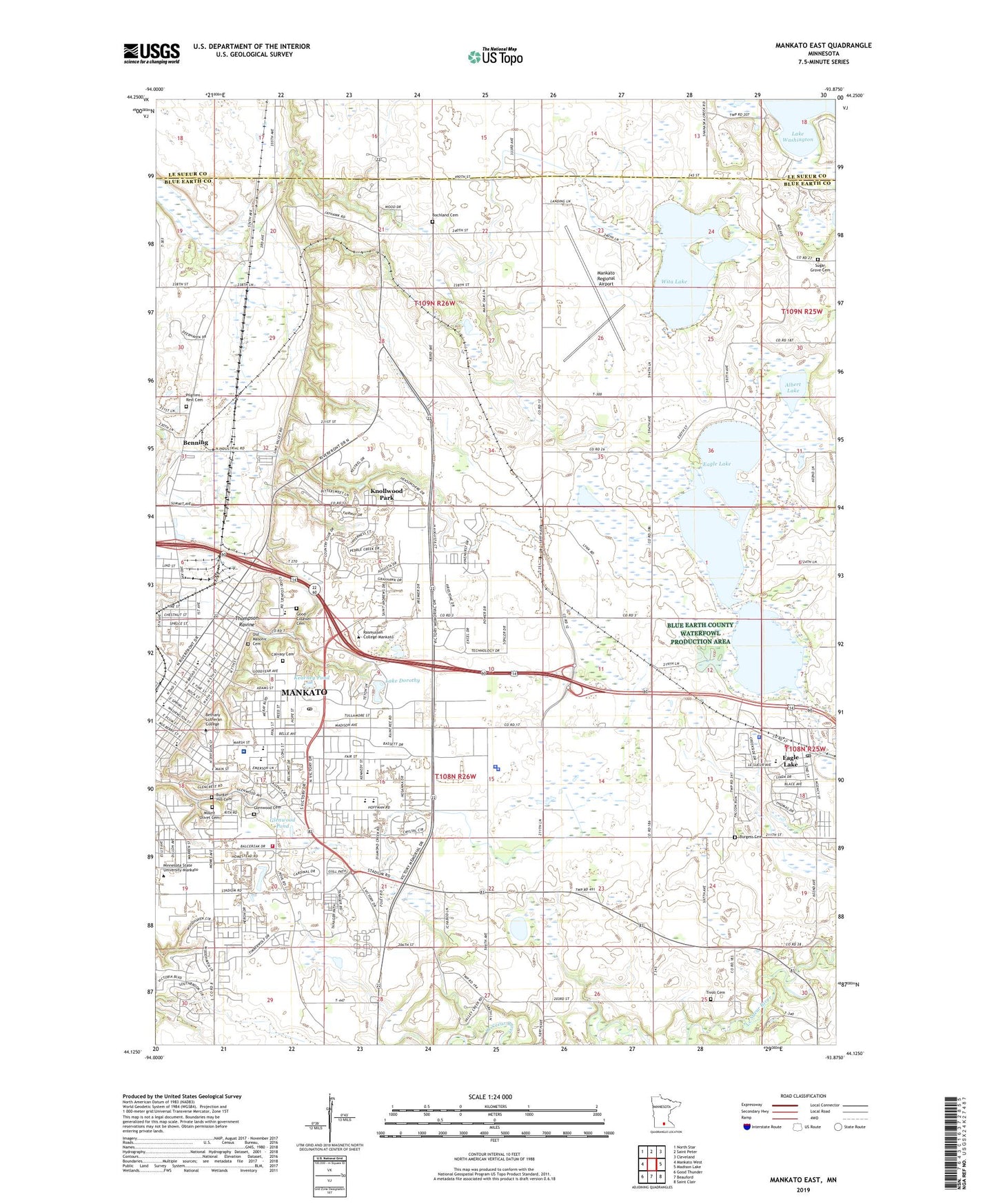
2019 topographic map quadrangle Mankato East in the state of Minnesota. Scale: 1:24000. Based on the newly updated USGS 7.5' US Topo map series, this map is in the following counties: Blue Earth, Le Sueur. The map contains contour data, water features, and other items you are used to seeing on USGS maps, but also has updated roads and other features. This is the next generation of topographic maps. Printed on high-quality waterproof paper with UV fade-resistant inks.
Quads adjacent to this one:
West: Mankato West
Northwest: North Star
North: Saint Peter
Northeast: Cleveland
East: Madison Lake
Southeast: Saint Clair
South: Beauford
Southwest: Good Thunder
Contains the following named places: Albert Lake, Alexander Park, Anderson Park, Belle Haven, Belle Mar Mall, Benning, Bethany Lutheran College, Bethel Baptist Church, Blue Earth County Courthouse, Blue Earth County Jail, Blue Earth County Sheriff's Office, Bochland Cemetery, Bunker Hill Cemetery, Burgess Cemetery, Calvary Apostolic Church, Calvary Cemetery, Chesley Skate Park, Christ the King Lutheran Church, Church of Christ, City of Eagle Lake, City of Mankato, Columbia Park, Eagle Lake, Eagle Lake 0 839, Eagle Lake Dam, Eagle Lake Elementary School, Eagle Lake Police Department, Eagle Lake Post Office, Eagle Lake Regency, Eagle Lake Volunteer Fire Department, Eastwood Manor Mobile Home Park, Epiphany Lutheran Church, Erlandson Park, Evangelical Free Church of Mankato, F Buscher Park, Fern Lake, First Christian Church, Fitzgerald Middle School, Franklin Rogers Field, Franklin School, Glenwood Cemetery, Glenwood Pond, Gold Cross Ambulance Mankato, Good Counsel Academy, Good Counsel Cemetery, Grace Lutheran Church, High Ciara Mobile Home Park, Highland Park, Hillside Assembly of God Church, Hilltop Park, Hilltop United Methodist Church, Hope Baptist Church, Hosanna Lutheran Church, Immanuel Hospital, Immanuel Lutheran Church, Jaycees Park, Kearney Pond, Kennedy School, Kenwood Heights Park, Key Park, Knollwood Park, KToe-AM (Mankato), Lake Dorothy, Lake Dorothy Park, Lime Siding, Lime Valley Mobile Home Park, Lions Lake, Lions Park, Loyola High School, Madison East Center, Madison East Post Office, Madison Heights Plaza, Mankato, Mankato Church of Christ, Mankato Clinic Limited, Mankato East High School, Mankato Fire Department Station 1, Mankato Fire Department Station 3, Mankato Golf Club, Mankato Regional Airport, Mayo Clinic Health System Mankato - Immanuel Saint Joseph's Hospital, Minnesota State Patrol District 2200, Minnesota State University - Mankato, Mount Olive Lutheran Church, Mount Olive Lutheran School, Mount Olivet Cemetery, Now Care Medical Center, Oaklawn Health Care Center, Old Masonic Cemetery, Open Door Health Center, Ophthalmology Associates Center, Orthopaedic and Fracture Clinic, Our Savior's Lutheran Church, Pilgrims Rest Cemetery, Premier Pond, Radiology Consultants Center, Rasmussen College - Mankato Campus, River Hills Mall, Saint Peter and Paul Elementary School, Saints Peter and Paul's Catholic Church, Salem Evangelical Lutheran Church, Seventh Day Adventist Church, Southhaven Mobile Home Park, Spruce Park, Sugar Grove Cemetery, Thomas Park, Thompson Ravine, Tivoli Cemetery, Tourtelotte Park, Township of Lime, Township of Mankato, Union School, Unitarian Universalist Fellowship of Mankato, University Park of Mankato, Viking Park, Washington Elementary School, Washington Park, Wildlife Safari Museum, Wita Lake, ZIP Code: 56001