MyTopo
Mankato West Minnesota US Topo Map
Couldn't load pickup availability
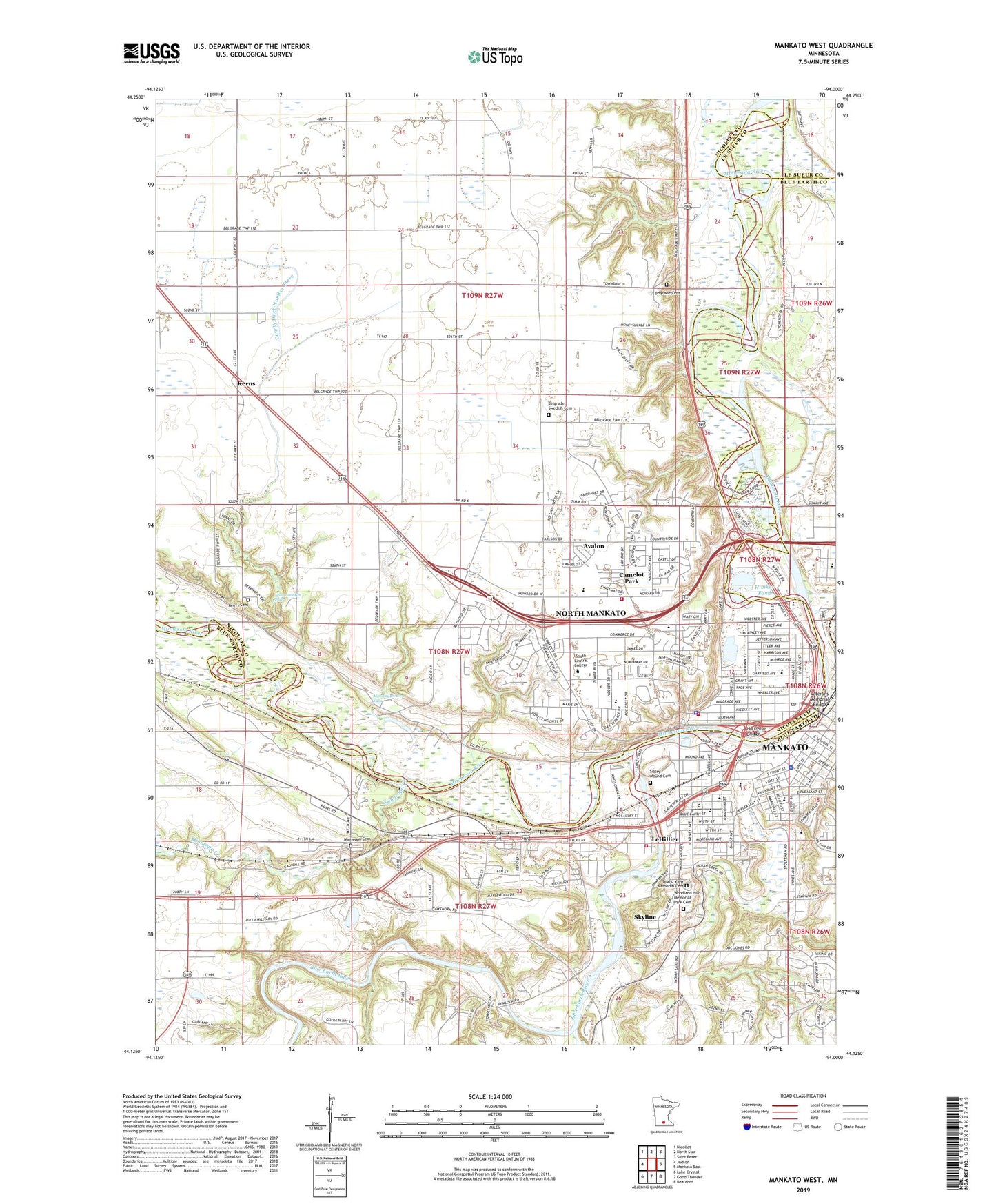
2022 topographic map quadrangle Mankato West in the state of Minnesota. Scale: 1:24000. Based on the newly updated USGS 7.5' US Topo map series, this map is in the following counties: Nicollet, Blue Earth, Le Sueur. The map contains contour data, water features, and other items you are used to seeing on USGS maps, but also has updated roads and other features. This is the next generation of topographic maps. Printed on high-quality waterproof paper with UV fade-resistant inks.
Quads adjacent to this one:
West: Judson
Northwest: Nicollet
North: North Star
Northeast: Saint Peter
East: Mankato East
Southeast: Beauford
South: Good Thunder
Southwest: Lake Crystal
This map covers the same area as the classic USGS quad with code o44094b1.
Contains the following named places: Avalon, Belgrade Avenue United Methodist Church, Belgrade Cemetery, Belgrade Swedish Cemetery, Bethlehem Lutheran Church, Blue Earth County Government Center, Blue Earth County Heritage Center Museum, Blue Earth County Library, Blue Earth River, Bluff Park, Bridges Community Elementary School, Budde Airport, Camelot Park, Carney Park, Caswell Park, Centenary United Methodist Church, Church of the Nazarene, City of North Mankato, City of Skyline, County Ditch Number Three, County Ditch Number Twelve, Covenant Family Church, Dakota Meadows Middle School, East Sibley Park, Evangelical Covenant Church, First Church of Christ Scientist, First Congregational United Church of Christ, First Presbyterian Church, Forest Heights Park, Garfield School, Good Shepherd Lutheran Church, Grace Baptist Church, Grace Christian School, Grand View Memorial Cemetery, Guns of the Pioneers Old West Gun Museum, Hillcrest Health Care Center, Hiniker Pond, Hiniker Pond Park, Holy Rosary Catholic Church, Holy Rosary School, Hoover School, Intergovernmental Center, ISJ Clinic-NorthRidge, Jefferson School, Jehovah's Witnesses Congregation, Judge Lorin P Cray Mansion - Mankato YWCA, KDOG-FM (North Mankato), Kerns, Kern's Cemetery, Kerns Post Office, KGAC-FM (Saint Peter), King Arthur Park, KMSU-FM (Mankato), KVRU-FM (Saint Peter), KYSM-AM (Mankato), KYSM-FM (Mankato), Land of Memories Campground, Land of Memories Park, Law Enforcement Center, Le Sueur River, LeHillier, Lincoln Junior High School, Mankato, Mankato 2 Post Office, Mankato Clinic-North Mankato, Mankato House Health Care Center, Mankato Lutheran Home, Mankato Police Department, Mankato Post Office, Mankato Region Historical Marker, Mankato West Senior High School, Messiah Lutheran Church, Minnemishinona Falls, Minneopa Cemetery, Minneopa Creek, Minneopa Golf Club, Minneopa State Park, Minnewankon Falls, Monroe School, Mount Kato Ski Area, North Links Golf Course, North Mankato, North Mankato City Hall, North Mankato Fire Department Station 1, North Mankato Fire Department Station 2, North Mankato Police Department, North Mankato Post Office, North Ridge Park, Northstar Bridge, Nortth Mankato Campus Library, One to One Clinic, R D Hubbard House, Rasmussen Park, Riverbend Estates, Riverview Park, Roosevelt Elementary School, Saint John the Baptist Catholic Church, Saint John's Episcopal Church, Saint Joseph the Worker Catholic Church, Saint Joseph the Worker School, Saint Mark Evangelical Lutheran Church, Saint Paul's Evangelical Lutheran Church, Seppman Mill Historical Marker, Sibley Mound Cemetery, Sibley Park, Skyline, Skyline Park, Skyline Volunteer Fire Department, South Bend Volunteer Fire Department, South Central College, Spring Lake Park, Stoltzman Park, Taylor Library, The Church of Jesus Christ of Latter Day Saints, Township of Belgrade, Township of South Bend, Trinity Church, Troost Pond, United Pentecostal Church, Veterans Memorial Bridge, Victory Life Church, Wallyn Park, Walter S Farm Park, Webster Fields, West Mankato Park, West Sibley Park, Wheeler Park, Wilson Campus School, Woodland Hills Memorial Park Cemetery, ZIP Code: 56003