MyTopo
Columbus North Mississippi US Topo Map
Couldn't load pickup availability
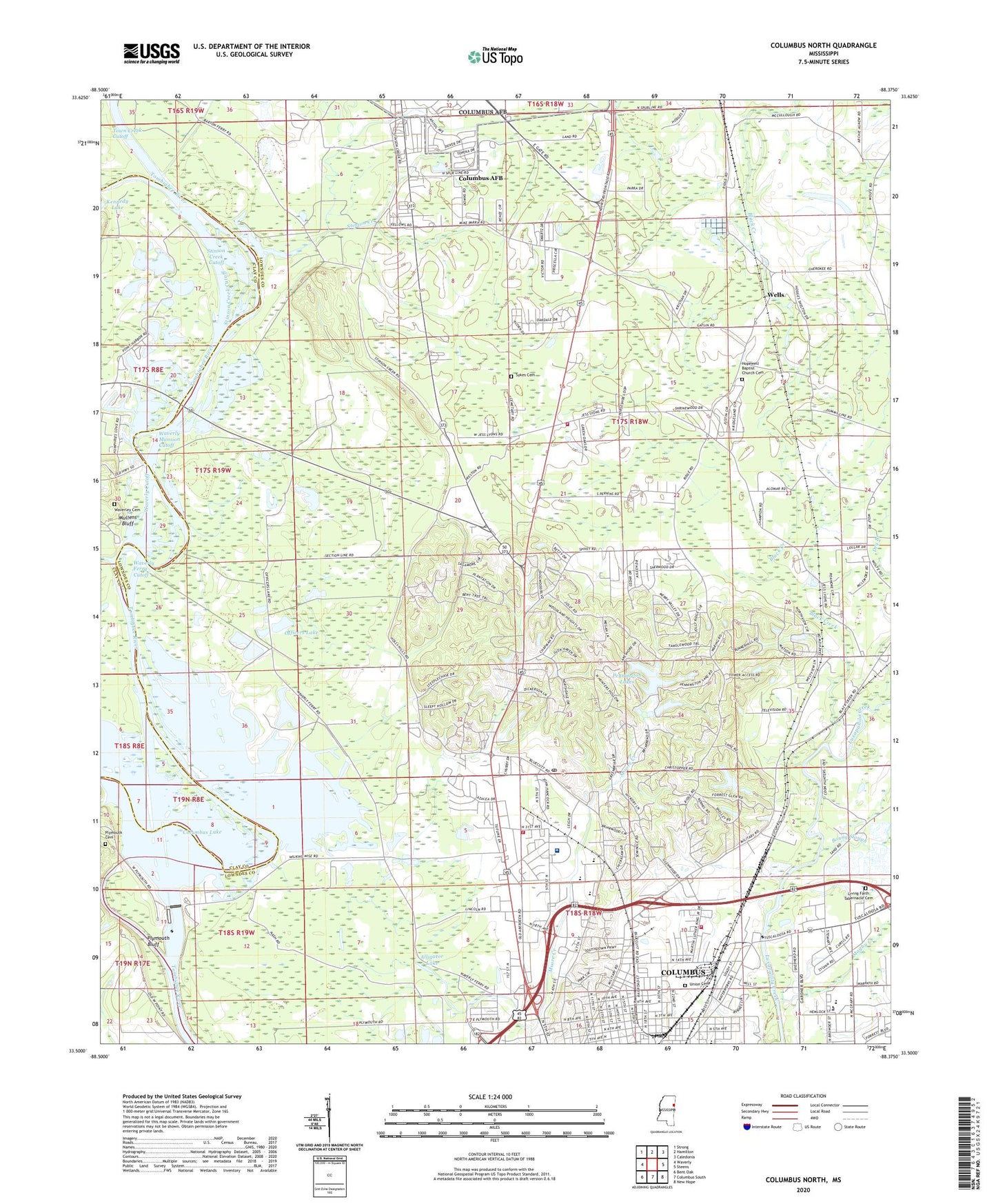
2024 topographic map quadrangle Columbus North in the state of Mississippi. Scale: 1:24000. Based on the newly updated USGS 7.5' US Topo map series, this map is in the following counties: Lowndes, Clay. The map contains contour data, water features, and other items you are used to seeing on USGS maps, but also has updated roads and other features. This is the next generation of topographic maps. Printed on high-quality waterproof paper with UV fade-resistant inks.
Quads adjacent to this one:
West: Waverly
Northwest: Strong
North: Hamilton
Northeast: Caledonia
East: Steens
Southeast: New Hope
South: Columbus South
Southwest: Bent Oak
This map covers the same area as the classic USGS quad with code o33088e4.
Contains the following named places: Alligator Lake, Antioch Church, Arrington Park, Baptist Behavioral Health Care Willowbrook, Baptist Memorial Hospital, Battery Heights, Beckrone, Bent Tree Plantation, Bethel Church, Black Creek, Bluecutt Estates, Bonny Slough, Brandon Elementary School, Briarwood, Broadacres United Methodist Church, Bunker Hill, Cady Hills, Caldwell High School, Calvary Church, Cedar Ridge School, Cherokee School, Christian Church, Christian Life Tabernacle, Church of Christ of Columbus, City of Columbus, Columbus Country Club, Columbus Fire Department Station 2, Columbus Fire Department Station 3, Columbus Lock and Dam, Columbus Post Office, Columbus-Lowndes Industrial Park North, Cook Junior High School, Cresent Estates, Dam Site East Bank Access Area, Dam Site West Bank Access Area, Eskridge, Evangel Assembly of God Church, Faith Temple Church of God in Christ, First Assembly of God Church, First Christian Church, Flynn, Fourth Street Missionary Baptist Church, Fox Run, Fox Run Colony, Frierson Church, Greenacres, Harvest Bible Church, Heritage Academy, Hickory Sticks, Highway Fifty Access Area, Holly Hills, Hopewell Baptist Church, Hughes Elementary School, Hunt High School, Immanuel Baptist Church, Immanuel Church, Jerusalem Temple Apostolic Church, Lee High School, Lee Park, Leigh Mall Shopping Center, Leighcrest, Lincecums Shoals, Lowndes County District 2 Volunteer Fire and Rescue Department Northwest Lowndes Station, Magby Creek, Magnolia Hill, Maranatha Faith Center, Midway Church, Missionary Union Baptist Church, Mississippi No Name 159 Dam, Mount Carmel Church, Mount Zion Church, Mount Zion Missionary Baptist Church, Mullens Bluff, Northaven Woods, Northside Baptist Church, Oakdale Park, Officers Lake, Our Savior Lutheran Church, Peachlands Landing, Pennington Lake Dam, Pennington Lakes, Phillips International Airport, Pitchlynns Ford, Pleasant Ridge Church, Plymouth Baptist Church, Plymouth Bluff, Plymouth Bluff Nature and Cultural Study Center, Plymouth Cemetery, Point Harbor, Prince of Peace Lutheran Church, Propst Highlands, Ridgeland, Roanoke Estates, Rolling Fork Estates, Rosewood Manor, Saint James United Methodist Church, Saint Peter Church, Sanctified Church, Sanders Chapel, Seventeen Section Church, Sherwood Forest, Sleepy Hollow, Stephens Chapel Baptist Church, Stinson Creek, Stinson Creek Cutoff, Stinson Creek Recreation Area, Stokes-Beard Elementary School, Supervisor District 2, Sythons Church, Temple Heights, Themerlaine, Tibbee Creek, Town Creek Cutoff, Union Academy, University Mall Shopping Center, WACR-AM (Columbus), WACR-FM (Columbus), Warden-Carden School, Waverley Cemetery, Waverly Cutoff, Waverly Ferry, Waverly Ferry Access Area, Waverly Ferry Cutoff, Waverly Mansion Cutoff, WCBI-AM (Columbus), WCBI-TV (Columbus), Wells, Wisteria Place, Woodland Heights, ZIP Code: 39705