
MyTopo
Lake Jacomo Missouri US Topo Map
Couldn't load pickup availability
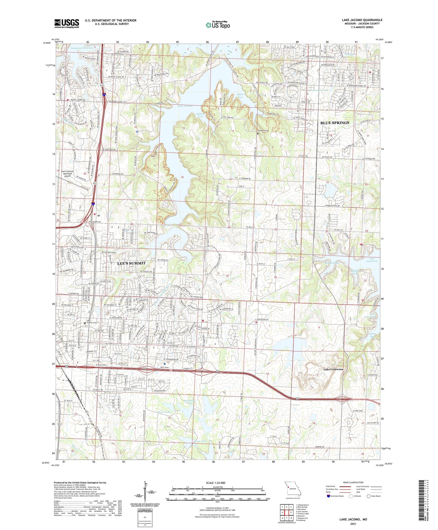
2021 topographic map quadrangle Lake Jacomo in the state of Missouri. Scale: 1:24000. Based on the newly updated USGS 7.5' US Topo map series, this map is in the following counties: Jackson. The map contains contour data, water features, and other items you are used to seeing on USGS maps, but also has updated roads and other features. This is the next generation of topographic maps. Printed on high-quality waterproof paper with UV fade-resistant inks.
Quads adjacent to this one:
West: Lees Summit
Northwest: Independence
North: Blue Springs
Northeast: Oak Grove
East: Tarsney Lakes
Southeast: Strasburg
South: Pleasant Hill
Southwest: Raymore
This map covers the same area as the classic USGS quad with code o38094h3.
Contains the following named places: Audubon Library, Baird School, Barber Lake Dam, Bayberry Plaza Shopping Center, Bernard C Campbell Middle School, Big Rock Bay, Buffalo Cove, Catclaw Lake, Catclaw Lake Dam, Center Point School, Central Jackson County Fire Protection District Station 5, Chapel Lakes Elementary School, Chapel Woods Golf Course Lake Dam, Christiansen Lake, Christiansen Lake Dam, City of Lake Lotawana, Colburn School, Community Church, Cordill - Mason Elementary School, Cottontail Lake, Cottontail Lake Dam, Cowherd Cemetery, Cyclone School, Daniel Young Elementary School, Delta School, Delta Woods Middle School, Fleming East Nature Preserve, Fleming Meeting Hall, Fleming Park, Franke Soccer Fields, Gopher Lake, Great Beginnings Early Education Center, Highland Park Elementary School, Jackrabbit Lake, Jackrabbit Lake Dam, Jackson County Park Headquarters, Jackson County Sheriff's Office, Jacomo Marina, James A Reed Memorial Wildlife Area, Kemper Outdoor Education Center, Lake Jacomo, Lake Jacomo Dam, Lake Lotawana, Lake Lotawana Police Department, Lake Nell, Lake Nell Dam, Lakewood Lake East, Lakewood Lakes, Langsford House School, Lee's Summit Cemetery, Lees Summit Fire Department Station 2, Lee's Summit Fire Department Station 4, Lees Summit Fire Department Station 6, Lee's Summit High School, Lee's Summit Medical Center, Lees Summit Town Center Shopping Center, Ligget Cove, Liggett Trail Education Center, Lone Oak School, Lone Summit Lake Dam, Lotawana Fire Protection District Station 1, Lotawana Fire Protection District Station 2, Mason Elementary School, Meadow Lane Elementary School, Miller Park Center, Missouri Department of Conservation Shelter, Missouri State Highway Patrol Troop A, Missouri Town, Moreland Ridge Middle School, Native Hoofed Animal Enclosure, North Prairie Lee Park, Number 38 Lake, Plover Lake, Plover Lake Dam, Prairie Lee Church, Prairie Lee Lake, Prairie Lee Lake Dam, Prairie Township Fire Protection District, Prairie View Elementary School, R B Rice Post Office, Radio Control Flying Field, Richardson Elementary School, Rotary Camp, Sailboat Cove, Sailboat Cove Launching and Mooring, Saint Marys School, Saint Matthew Church, South Prairie Lee Park, Stafford Airport, Summit Springs Shopping Center, Sunset Bay, Sunset Valley Elementary School, Tennison School, Township of Prairie, Underwood Elementary School, Valle Vista Shopping Center, Woodland Elementary School, Woods Chapel, Wright School, ZIP Codes: 64063, 64064, 64086


