MyTopo
Richwoods Missouri US Topo Map
Couldn't load pickup availability
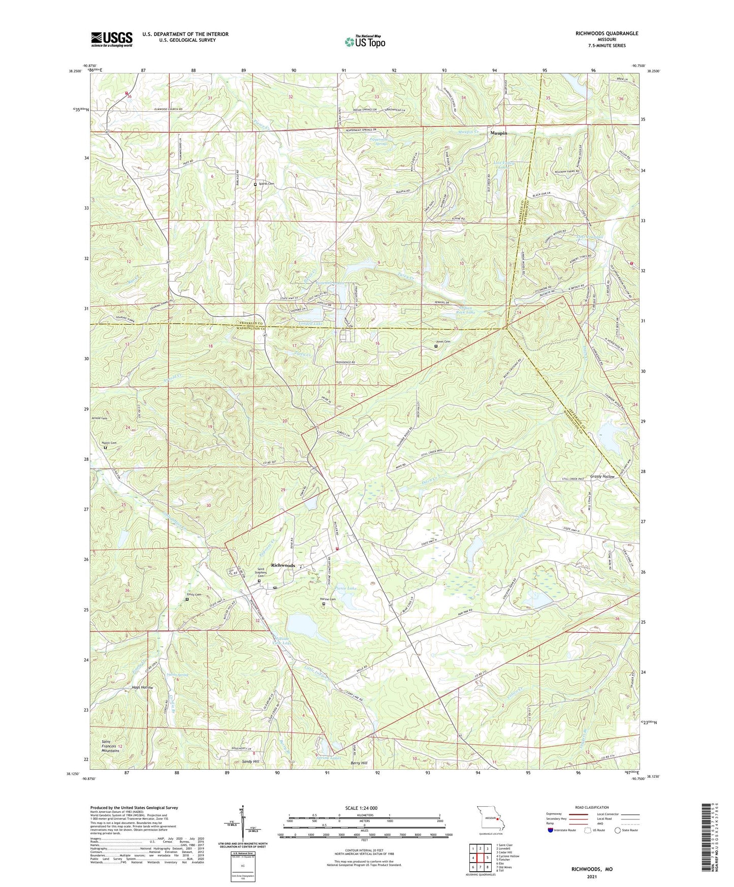
2021 topographic map quadrangle Richwoods in the state of Missouri. Scale: 1:24000. Based on the newly updated USGS 7.5' US Topo map series, this map is in the following counties: Washington, Franklin, Jefferson. The map contains contour data, water features, and other items you are used to seeing on USGS maps, but also has updated roads and other features. This is the next generation of topographic maps. Printed on high-quality waterproof paper with UV fade-resistant inks.
Quads adjacent to this one:
West: Cyclone Hollow
Northwest: Saint Clair
North: Lonedell
Northeast: Cedar Hill
East: Fletcher
Southeast: Tiff
South: Old Mines
Southwest: Ebo
Contains the following named places: Alpine Lake Dam, Asplin Cemetery, Assaf Lake Dam, Berry Branch, Berry Hill, Berry School, Big Four Mine Dam, Board Lead Diggings, Calico School, Click Lake Dam, Cool Valley Lake Dam, Cordia Branch, Davis Lake Dam, De Soto Rural Fire Protection District Station 6, Desoto Mining Comapny Pit and Plant A Dam, Desoto Mining Company Pit and Plant B Dam, Ditch Creek Dam, Edmonds and Wilcox Furnace and Mill, Elmwood Church, Elmwood School, Emily Cemetery, Florendell Dam, French Lead Diggings, Hays Hollow, Hensley, Hillside View Lake, Hoffman Lake Dam, Horine Cemetery, Hurricane, Indian Rock Lake, Indian Rock Lake Dam, Indian Spring, Joan Lake, Joan Lake Airport, Jones Cemetery, La Beaume Lead Diggings, Lake Aggravation Dam, Lake Tranquil, Lake Tranquil Dam, Little Indian Creek Dam, Lonedell Lake, Lonedell Lake Dam, Lonedell Lakes, Lost Valley Lake West Dam, Lost Valley Lakes, Maupin, McMullin School, Mononame 551 Dam, Mononame 558 Dam, Mononame 563 Dam, Mundy Lead Diggings, Old Ditch School, Papoose Creek, Peppermint Springs, Perkins East Lower Lake Dam, Perkins East Upper Lake Dam, Perkins West Lake Dam, Pierce Lake, Pierce Lake Dam, Pinery Creek, Pinery School, Providence Church, Providence School, Richwoods, Richwoods Fire Protection District, Richwoods Lead Mine, Richwoods Mine B Mill Dam, Richwoods Pond Dam, Richwoods School, Saint Clair Fire Protection District Station 4, Saint Stephens Catholic Church, Saint Stephens Cemetery, Sixteenth Section Lead Diggings, Skewes Lead Diggings, Sparks Cemetery, Spring Lake, Spring Lake Dam, Spring Lakes, Stieren Lake Dam, Taggett Branch, The Fraction Lead Diggings, Township of Richwoods, Turkey Branch School, Turkey Creek, Tyrey Creek, ZIP Code: 63071