MyTopo
Old Mines Missouri US Topo Map
Couldn't load pickup availability
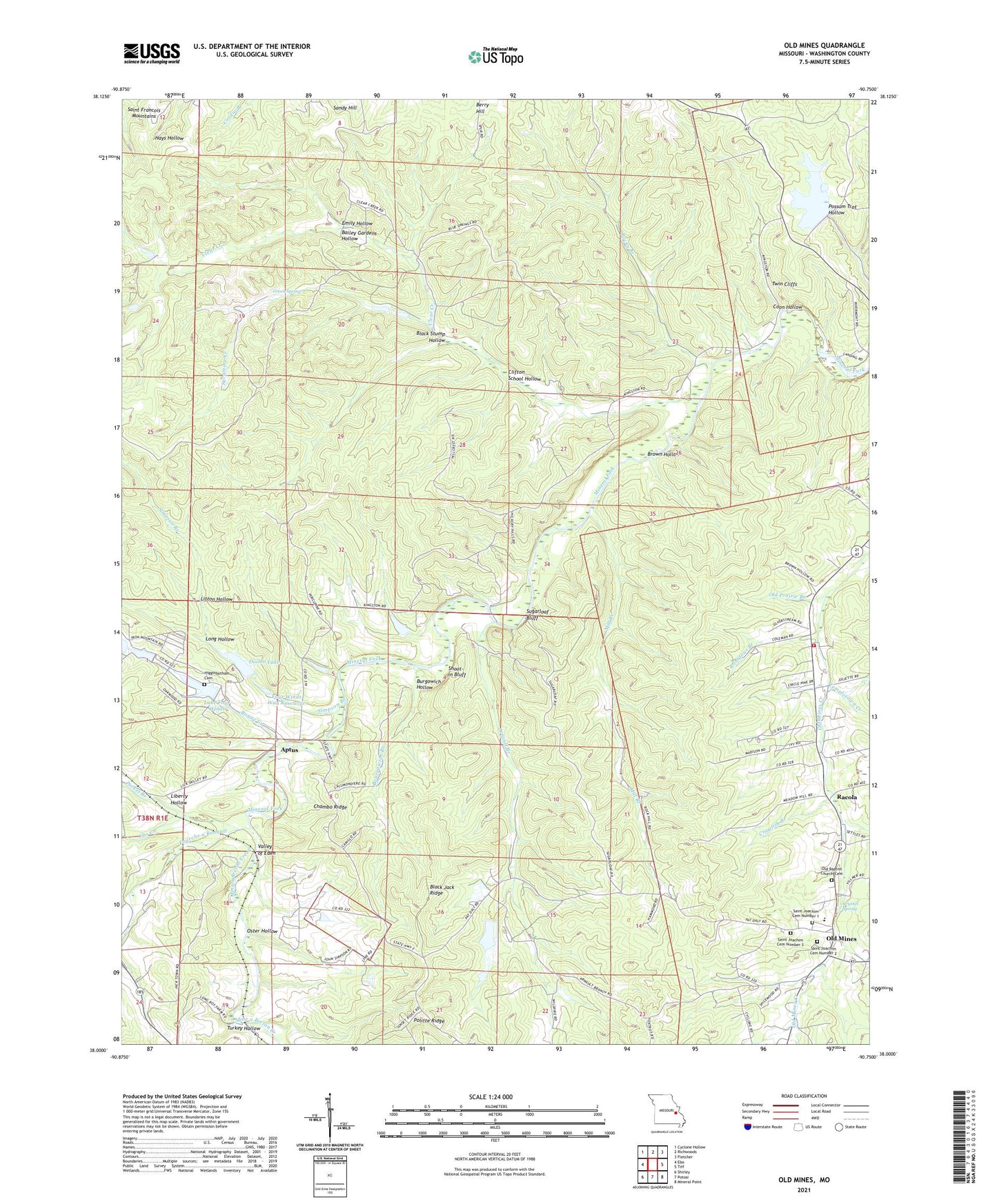
2021 topographic map quadrangle Old Mines in the state of Missouri. Scale: 1:24000. Based on the newly updated USGS 7.5' US Topo map series, this map is in the following counties: Washington. The map contains contour data, water features, and other items you are used to seeing on USGS maps, but also has updated roads and other features. This is the next generation of topographic maps. Printed on high-quality waterproof paper with UV fade-resistant inks.
Quads adjacent to this one:
West: Ebo
Northwest: Cyclone Hollow
North: Richwoods
Northeast: Fletcher
East: Tiff
Southeast: Mineral Point
South: Potosi
Southwest: Shirley
This map covers the same area as the classic USGS quad with code o38090a7.
Contains the following named places: Aptus, Arnault Branch, Arnault Branch Mine Dam, Arnault Church, Arnault School, Bailey Gardens Hollow, Bee Lead Diggings, Black Jack Ridge, Black Stump Hollow, Bourgawich Branch, Bourgawich Lead Mine, Bourgowich School, Brown Hollow, Burgowich Hollow, Chambo Ridge, Clear Creek, Cliff Cave Mine, Clifton School, Clifton School Hollow, Coon Hollow, Crawfish Branch, Crawfish Lead Diggings, Cresswells Lead Furnace, Cruise, Crystal Spring, Diablo Lake, Dry Hollow Lead Diggings, DuCloes Lead Diggings, Ebo Creek, Elliot Lead Diggings, Emily Hollow, Flynns Lead Diggings, Four Winds Way Dam, Four Winds Way Reservoir, Fourche a Renault, Gobbetts Lead Diggings, Green Spring, Higginbotham Cemetery, Hunts Lead Diggings, Jones Lake Dam, Kingston School, Lake Four Winds, Liberty Hollow, Litton Hollow, Long Hollow, Lumkins Mill, Mill Branch, Mine a Breton Creek, Mud Town Creek, Number 875 Dam, Old Baptist Church Cemetery, Old Mines, Old Prairie Branch, Old Prairie Lead Diggings, Oster Hollow, Pfizer Incorporated Lake Dam, Pioneer Rod and Gun Club Dam, Politte Ridge, Potosi Fire Protection District House 4, Pucket Branch, Racola, Racola Tailings Dam, Robidoux, Robidoux Branch, Rocky Branch, Rogue Creek, Saint Joachim Catholic Church, Saint Joachim Cemetery Number 1, Saint Joachim Cemetery Number 2, Saint Joachim Cemetery Number 3, Saint Joachim School, Sampson Lake Dam, Sandy Hill, Scott Lead Diggings, Shoot-in Bluff, Shores Lead Mine, Simpson Branch, Somers Lead Diggings, Star Mine Dam, Sugarloaf Bluff, Sycamore Creek, Templetown Creek, Turkey Hollow, Twin Cliffs, Valley of Eden, Wet Lead Diggings