MyTopo
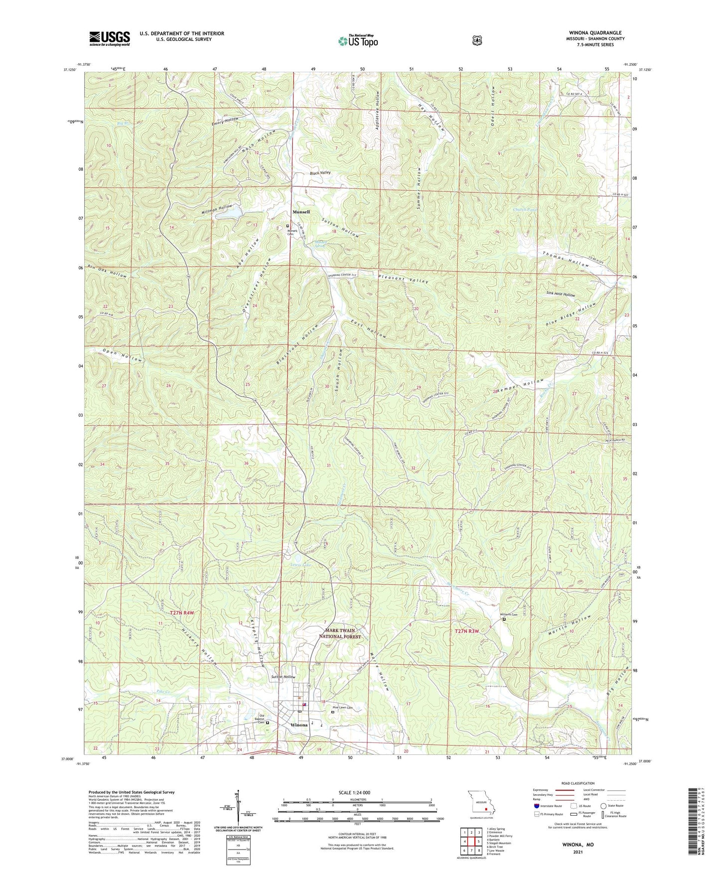
Winona Missouri US Topo Map
Couldn't load pickup availability
Also explore the Winona Forest Service Topo of this same quad for updated USFS data
2021 topographic map quadrangle Winona in the state of Missouri. Scale: 1:24000. Based on the newly updated USGS 7.5' US Topo map series, this map is in the following counties: Shannon. The map contains contour data, water features, and other items you are used to seeing on USGS maps, but also has updated roads and other features. This is the next generation of topographic maps. Printed on high-quality waterproof paper with UV fade-resistant inks.
Quads adjacent to this one:
West: Bartlett
Northwest: Alley Spring
North: Eminence
Northeast: Powder Mill Ferry
East: Stegall Mountain
Southeast: Fremont
South: Low Wassie
Southwest: Birch Tree
This map covers the same area as the classic USGS quad with code o37091a3.
Contains the following named places: Abe Hollow, Allen Pond, Appletree Hollow, Big Hollow, Big Spring School, Black Valley, Blackroot Hollow, Church Pond, City of Winona, Deel Lake Dam, District Office Forest Service - USDA, East Hollow, Emory Hollow, Hickory Hollow, Hunt Lake Dam, Kemper Hollow, Klepzig Hollow, Lewis Lake, Lewis Lake Picnic Area, Lions Club Park, Mahan Roadside Park, Marie Hollow, Mark Twain National Forest Eleven Point Ranger District Winona Office, Martin Hollow, Millman Hollow, Mononame 148 Dam, Munsell, Munsell School, Munsell Spring, Nash Hollow, Overstreet Hollow, Pine Lawn Cemetery, Pine Ridge Hollow, Pleasant Valley, Rocky Creek State Forest, Shawne, Sink Hole Hollow, South Hollow, Summer Hollow, Sutton Hollow, Sutton Mine, Thomas Hollow, Township of Winona, Williams Cemetery, Winona, Winona Junction, Winona Police Department, Winona Post Office, Winona Volunteer Fire Department