
MyTopo
Billings East Montana US Topo Map
Couldn't load pickup availability
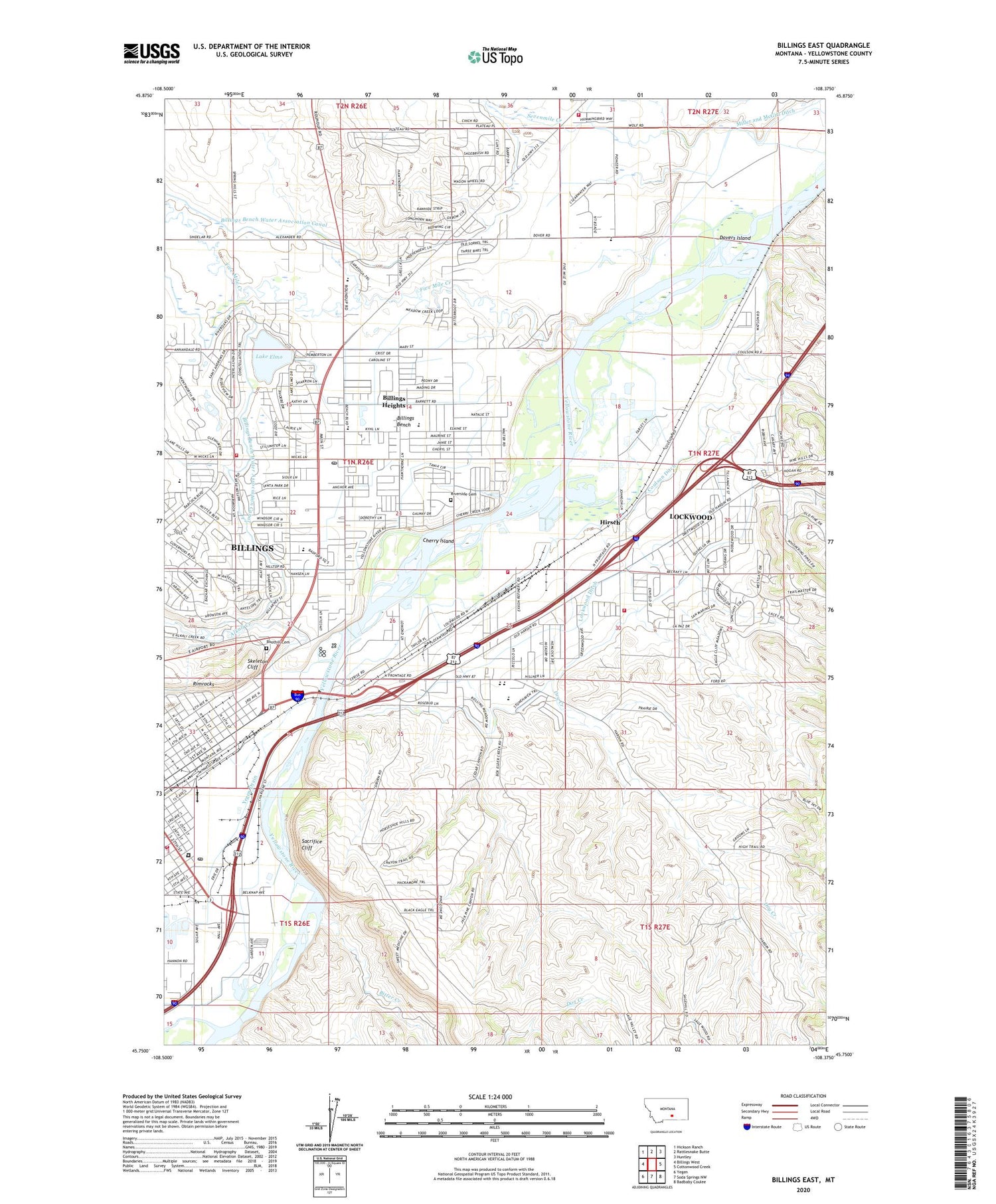
2020 topographic map quadrangle Billings East in the state of Montana. Scale: 1:24000. Based on the newly updated USGS 7.5' US Topo map series, this map is in the following counties: Yellowstone. The map contains contour data, water features, and other items you are used to seeing on USGS maps, but also has updated roads and other features. This is the next generation of topographic maps. Printed on high-quality waterproof paper with UV fade-resistant inks.
Quads adjacent to this one:
West: Billings West
Northwest: Hickson Ranch
North: Rattlesnake Butte
Northeast: Huntley
East: Cottonwood Creek
Southeast: Badbaby Coulee
South: Soda Springs NW
Southwest: Yegen
Contains the following named places: 01N26E01ABCC01 Well, 01N26E01BCCC01 Well, 01N26E02DCBD01 Well, 01N26E10ABBA01 Well, 01N26E12BCBB01 Well, 01N26E13BABB01 Well, 01N26E15A___01 Well, 01N26E22DCBD01 Well, 01N26E23ACDB01 Well, 01N26E23ADCD01 Well, 01N26E23B___01 Well, 01N26E23BAAB01 Well, 01N26E25CA__01 Well, 01N26E36B___01 Well, 01N27E05AADC01 Well, 01N27E06CDDD01 Well, 01N27E17CABA01 Well, 01N27E18ADDB01 Well, 01N27E19DBCB01 Well, 01N27E20CAAD01 Well, 01N27E31AACD01 Well, 01N27E32BCCC01 Well, 01N27E33BACB01 Well, 01S26E02BADC01 Well, 01S26E02BC__01 Well, 01S27E04ACCC01 Well, 02N27E31CDAC01 Well, Alkali Creek, Alkali Siphon, American Medical Response Station 1 Headquarters, American Medical Response Station Central Station, Billings Bench, Billings Bench School, Billings Bench Water Association Canal, Billings Fire Department Station 2, Billings Fire Department Station 6, Billings Heights, Billings Post Office, Bitter Creek, Boothill Cemetery, Cherry Island, Clarks Crossing, Conoco Phillips Emergency Response Team, Coulson Ditch, Dovers Island, Dry Creek, East Bridge Fishing Access Site, Elmo Lake Dam, Exxon - Mobil Fire and Emergency Services Response Team, Five Mile Creek, Halverson Number 1 Dam, Hawthorn Church, Hawthorn School, Hirsch, Independent Elementary School, Josephine Park, KCTR-FM (Billings), KIDX-FM (Billings), KOHZ-FM (Billings), KPQD-TV (Billings), KTVQ-TV (Billings), KULR-TV (Billings), KURL-AM (Billings), KVME-TV (Billings), KYYA-FM (Billings), KZLS-FM (Billings), Lake Elmo, Lockwood, Lockwood Ambulance, Lockwood Census Designated Place, Lockwood Ditch, Lockwood Rural Fire District 8, Lockwood Schools, Lockwood Sheriff's Office, MetraPark, Miller and McGirl Ditch, Montana Highway Patrol District 4 Office, Montana Narcotics Bureau Division of Criminal Investigation, Montana Women's Prison, North Park School, Pine Hill School, Pioneer School, Place Where the White Horse Went Down Historical Marker, Riverside Cemetery, Ronald Reagan Post Office, Sacrifice Cliff, Sevenmile Creek, Skeleton Cliff, South Park, Taft School, Yegen Drain


