MyTopo
Crow Agency Montana US Topo Map
Couldn't load pickup availability
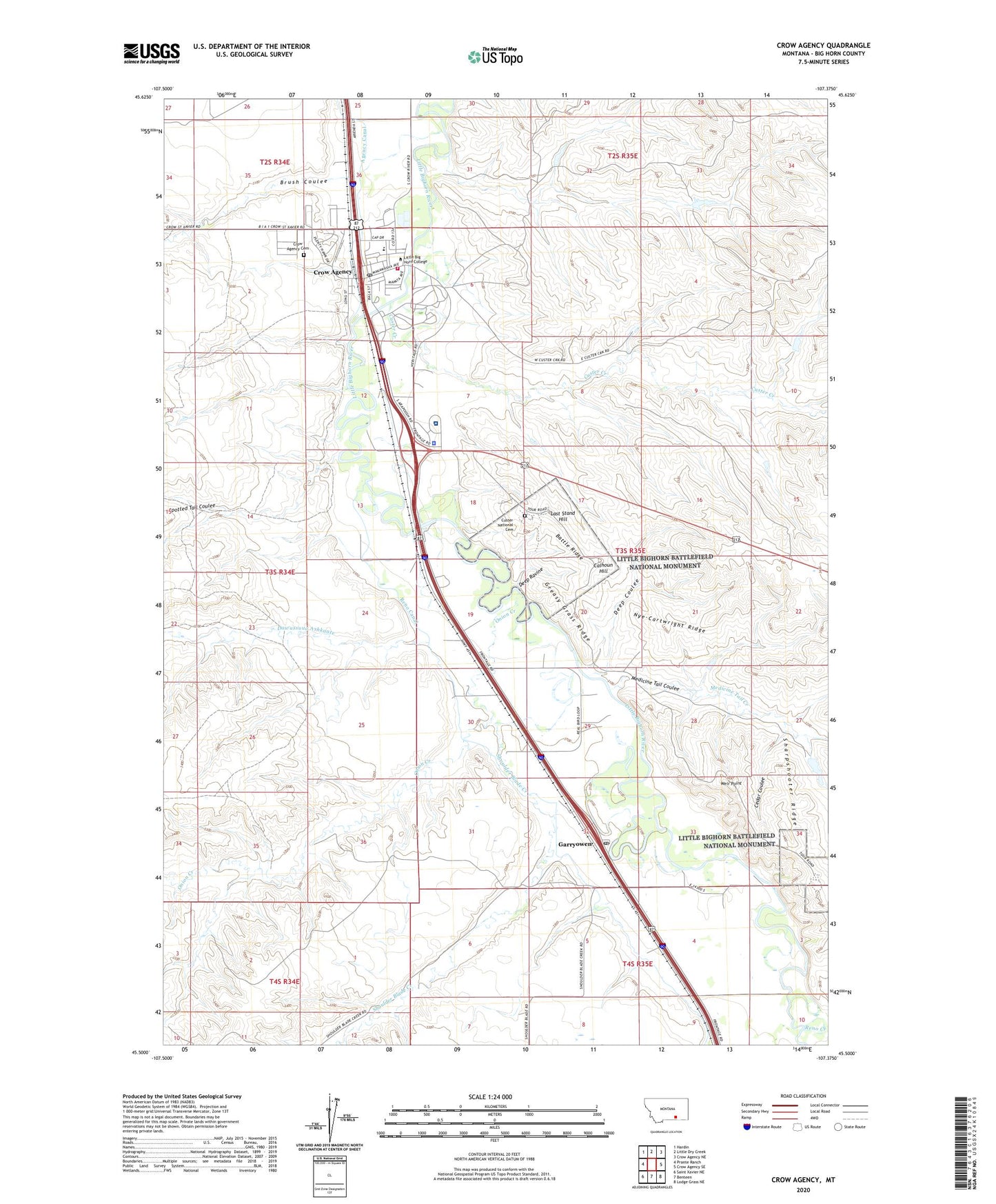
2024 topographic map quadrangle Crow Agency in the state of Montana. Scale: 1:24000. Based on the newly updated USGS 7.5' US Topo map series, this map is in the following counties: Big Horn. The map contains contour data, water features, and other items you are used to seeing on USGS maps, but also has updated roads and other features. This is the next generation of topographic maps. Printed on high-quality waterproof paper with UV fade-resistant inks.
Quads adjacent to this one:
West: Prante Ranch
Northwest: Hardin
North: Little Dry Creek
Northeast: Crow Agency NE
East: Crow Agency SE
Southeast: Lodge Grass NE
South: Benteen
Southwest: Saint Xavier NE
This map covers the same area as the classic USGS quad with code o45107e4.
Contains the following named places: 02S34E25CD__01 Well, 02S34E35BBAB01 Well, 02S34E36AB__01 Well, 02S34E36AC__01 Well, 02S34E36ACCC01 Well, 02S34E36ACCC02 Well, 02S34E36CA__01 Well, 02S34E36CA__02 Well, 02S34E36DB__01 Well, 02S34E36DB__02 Well, 02S34E36DB__03 Well, 02S34E36DB__04 Well, 02S34E36DB__05 Well, 02S34E36DB__06 Well, 02S34E36DB__07 Well, 02S34E36DD__01 Well, 02S35E30CCBC01 Well, 02S35E31BB__01 Well, 02S35E31BC__01 Well, 03S34E01AA__01 Well, 03S34E01AC__01 Well, 03S34E01AC__04 Well, 03S34E01AC__05 Well, 03S34E01AC__06 Well, 03S34E01AC__07 Well, 03S34E01AC__08 Well, 03S34E01AD__01 Well, 03S34E01AD__02 Well, 03S34E01BA__01 Well, 03S34E01BD__01 Well, 03S34E01DC__01 Well, 03S34E12DA__01 Well, 03S34E12DBAB01 Well, 03S34E12DCBA01 Well, 03S34E13AA__01 Well, 03S34E13AB__01 Well, 03S34E13DA__01 Well, 03S34E24AA__01 Well, 03S34E24AAAC01 Well, 03S34E36DC__01 Well, 03S35E13CDAA01 Well, 03S35E18BA__01 Well, 03S35E18BC__01 Well, 03S35E18DABD01 Well, 03S35E18DCBD01 Well, 03S35E18DCCB01 Well, 03S35E19AABA01 Well, 03S35E19AABA02 Well, 03S35E19BA__01 Well, 03S35E19BC__01 Well, 03S35E19CA__01 Well, 03S35E19CBDD01 Well, 03S35E19CC__01 Well, 03S35E19CD__01 Well, 03S35E19DC__01 Well, 03S35E19DCDA01 Well, 03S35E19DD__01 Well, 03S35E20CC__01 Well, 03S35E24AADB01 Well, 03S35E29ABCC01 Well, 03S35E29BDAA01 Well, 03S35E29CA__01 Well, 03S35E29CC__01 Well, 03S35E29CC__02 Well, 03S35E29CD__01 Well, 03S35E29CDBA01 Well, 03S35E29DA__01 Well, 03S35E29DA__02 Well, 03S35E29DB__01 Well, 03S35E30AB__01 Well, 03S35E30BA__01 Well, 03S35E30BADA01 Well, 03S35E30DA__01 Well, 03S35E32AB__01 Well, 03S35E32AC__01 Well, 03S35E32BA__01 Well, 03S35E32DB__01 Well, 03S35E32DB__02 Well, 03S35E32DBDA01 Well, 03S35E32DDABO1 Well, 0435S05ACAA01_ Well, 04S35E03BB__01 Well, 04S35E03CB__01 Well, 04S35E03CD__01 Well, 04S35E04AABC01 Well, 04S35E04AACC01 Well, 04S35E04AB__01 Well, 04S35E04BB__01 Well, 04S35E04BB__02 Well, 04S35E04BBBC01 Well, 04S35E04BBBC02 Well, 04S35E04BC__01 Well, 04S35E04DDDD01 Well, 04S35E05AA__01 Well, 04S35E05AB__01 Well, 04S35E05CDCC01 Well, 04S35E06AA__01 Well, 04S35E06AAAB01 Well, 04S35E06AAAB02 Well, 04S35E06AAAB03 Well, 04S35E06BDCD01 Well, 04S35E09AA__01 Well, 04S35E09AB__01 Well, 04S35E09BA__01 Well, 04S35E10BB__01 Well, 59031, Absaloka Baptist Church, B B Naylor Dam, Battle Ridge, Brush Coulee, Burgess Memorial Baptist Church, Calhoun Hill, Cedar Coulee, Crow Agency, Crow Agency Cemetery, Crow Agency Census Designated Place, Crow Agency Fire Department, Crow Agency Police Department, Crow Agency Post Office, Crow Agency School, Crow Agency Sewage Lagoons Dam, Crow Number 59 Dam, Crow Number 6 Dam, Crow Revival Center, Custer Creek, Custer National Cemetery, D S Scott Number 2 Dam, Dawussuua Ashkaate, Deep Coulee, Deep Ravine, Garryowen, Garryowen Historical Marker, Garryowen Mission School, Garryowen Post Office, Greasy Grass Ridge, IHS Crow / Northern Cheyenne Hospital, Last Stand Hill, Little Big Horn Camp, Little Big Horn College, Little Bighorn Battlefield National Monument, Little Bighorn Battlefield Visitor Center, Lutheran Church - Missouri Synod, Medicine Tail Coulee, Medicine Tail Creek, Medicine Tail Ford, National Cemetery Military Reservation, Nye-Cartwright Ridge, Onion Creek, Reno Canal, Reno Creek, Reno-Benteen Battlefield, Retreat Crossing, Saint Dennis Parish, Seventh Cavalry Memorial, Sharpshooter Ridge, Shoulder Blade Creek, Spirit of Life Foursquare Church, Spotted Tail Coulee, The Roundhouse, Weir Point