MyTopo
Frazer Montana US Topo Map
Couldn't load pickup availability
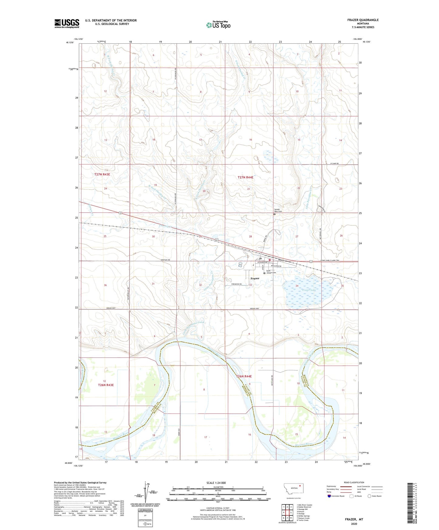
2024 topographic map quadrangle Frazer in the state of Montana. Scale: 1:24000. Based on the newly updated USGS 7.5' US Topo map series, this map is in the following counties: Valley, McCone. The map contains contour data, water features, and other items you are used to seeing on USGS maps, but also has updated roads and other features. This is the next generation of topographic maps. Printed on high-quality waterproof paper with UV fade-resistant inks.
Quads adjacent to this one:
West: Kintyre
Northwest: Milk River Coulee
North: Dubbe Reservoir
Northeast: Oswego NW
East: Oswego
Southeast: Turtle Creek
South: Pasture Creek
Southwest: McRae Springs
This map covers the same area as the classic USGS quad with code o48106a1.
Contains the following named places: 26N43E12DD__01 Well, 26N43E24AA__01 Well, 26N44E05CC__01 Well, 26N44E05DD__01 Well, 26N44E07AA__01 Well, 26N44E07AD__01 Well, 26N44E07AD__02 Well, 26N44E07BA__01 Well, 26N44E07DA__01 Well, 26N44E07DA__02 Well, 26N44E07DD__01 Well, 26N44E08AA__01 Well, 26N44E08AB__01 Well, 26N44E08AC__01 Well, 26N44E08AC__02 Well, 26N44E08BA__01 Well, 26N44E08BA__02 Well, 26N44E08CB__01 Well, 26N44E08DD__01 Well, 26N44E09AC__01 Well, 26N44E09BC__01 Well, 26N44E09CB__01 Well, 26N44E09CC__01 Well, 26N44E10BC__01 Well, 26N44E11BB__01 Well, 26N44E11CD__01 Well, 26N44E14CC__01 Well, 26N44E15BB__01 Well, 26N44E15BC__01 Well, 26N44E16BC__01 Well, 26N44E16CA__01 Well, 26N44E16CC__01 Well, 26N44E16CC__02 Well, 26N44E17AA__01 Well, 26N44E17AA__02 Well, 26N44E17AA__03 Well, 26N44E17AB__01 Well, 26N44E17BD__01 Well, 26N44E17CB__01 Well, 26N44E17CC__01 Well, 26N44E17CD__01 Well, 26N44E17DB__01 Well, 26N44E17DC__01 Well, 26N44E17DC__02 Well, 26N44E18AA__01 Well, 26N44E18AC__03 Well, 26N44E18AD__01 Well, 26N44E18AD__02 Well, 26N44E18CD__01 Well, 26N44E18DA__01 Well, 26N44E18DC__01 Well, 27N43E25AD__01 Well, 27N44E26CB__01 Well, 27N44E27BC__01 Well, 27N44E27BCCA01 Well, 27N44E28CC__01 Well, 27N44E28DC__01 Well, 27N44E28DD__01 Well, 27N44E31AA__01 Well, 27N44E32CA__01 Well, 27N44E32DC__01 Well, 27N44E33AC__01 Well, 27N44E33AD__01 Well, 27N44E33BC__01 Well, 27N44E34AC__01 Well, 27N44E34ACAB01 Well, Big Sky Indian Chapel, Blackmon Post Office, Charley Creek, Dakota Presbyterian Church, East Fork Charley Creek, Equity Cooperative Elevator, Frazer, Frazer Census Designated Place, Frazer Lake, Frazer Lake Dam East, Frazer Post Office, Frazer School, Frazer Volunteer Fire Company, Government Day School, Hungry Creek, In Memoriam Historical Marker, Inperial Elevator, Kintyre Creek, Lenox, Little Porcupine Creek, Little Porcupine Dam, Saint Joseph Cemetery, Saint Josephs Catholic Church, Saint Pauls Evangelical Lutheran Church, Smith-Tyner Elevator, Sunset Rest Cemetery, West Fork Charley Creek