MyTopo
Greenhorn Mountain Montana US Topo Map
Couldn't load pickup availability
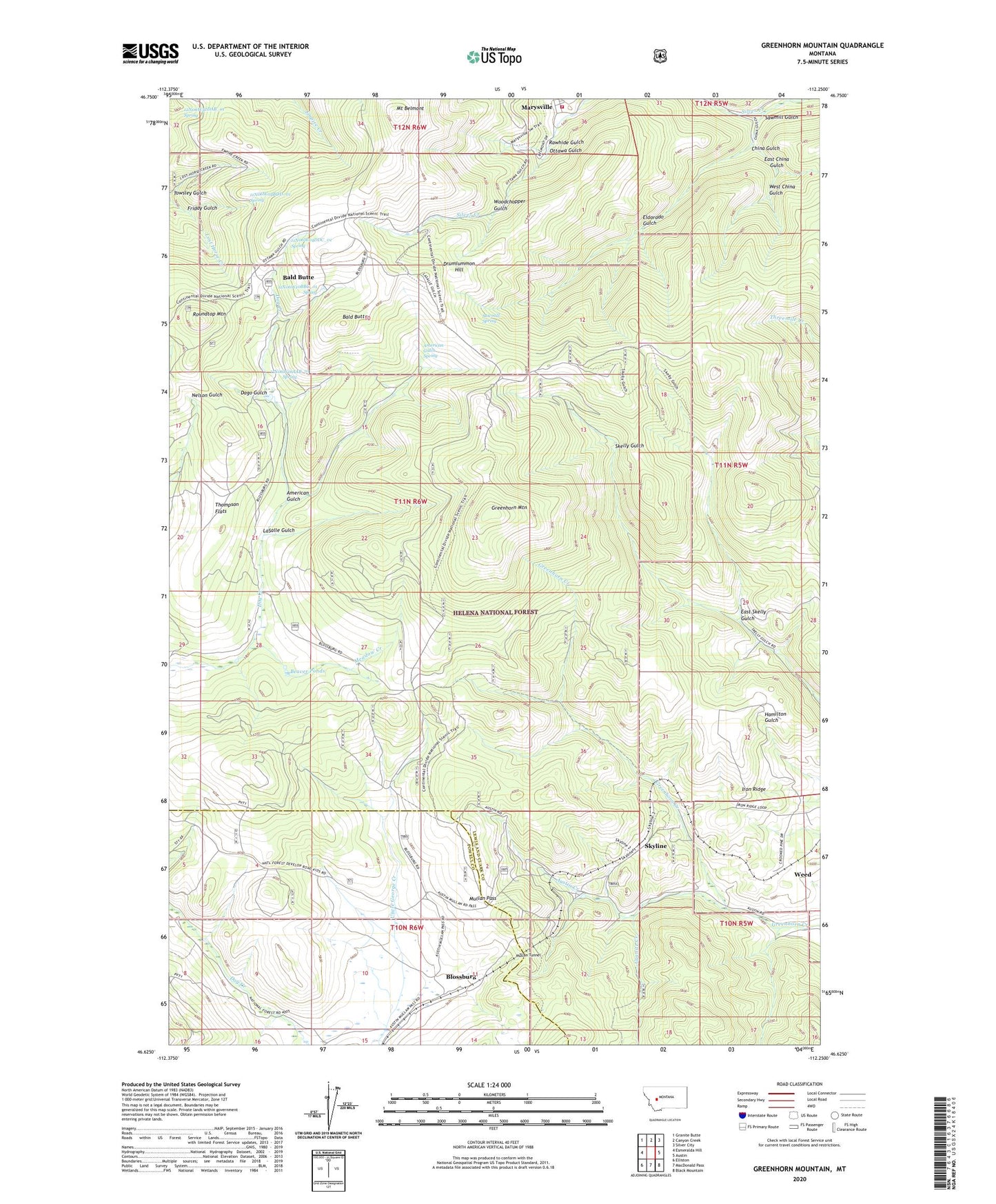
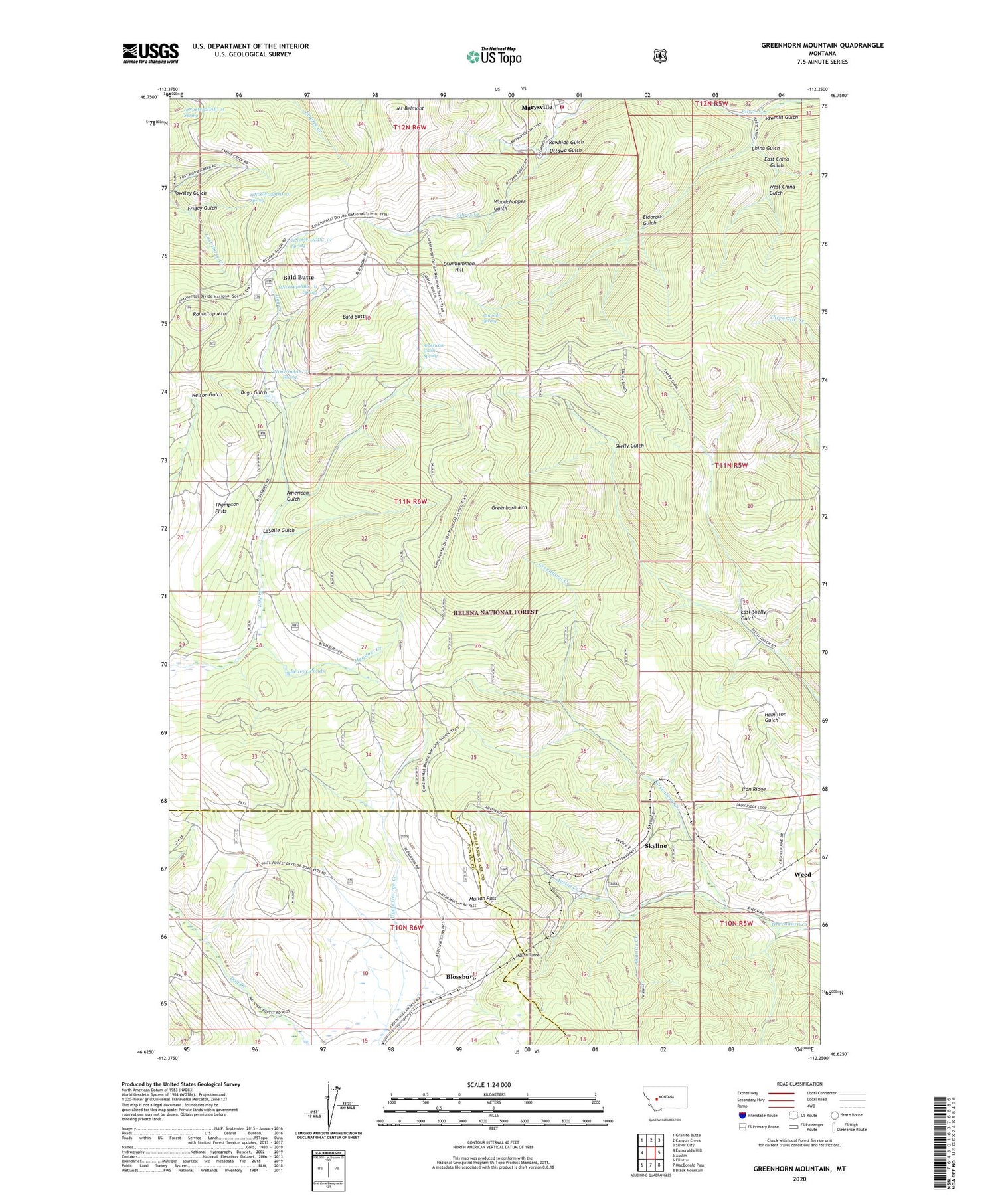
2020 topographic map quadrangle Greenhorn Mountain in the state of Montana. Scale: 1:24000. Based on the newly updated USGS 7.5' US Topo map series, this map is in the following counties: Lewis and Clark, Powell. The map contains contour data, water features, and other items you are used to seeing on USGS maps, but also has updated roads and other features. This is the next generation of topographic maps. Printed on high-quality waterproof paper with UV fade-resistant inks.
Quads adjacent to this one:
West: Esmeralda Hill
Northwest: Granite Butte
North: Canyon Creek
Northeast: Silver City
East: Austin
Southeast: Black Mountain
South: MacDonald Pass
Southwest: Elliston
Contains the following named places: 10N05W05CDBA01 Well, 11N06W04BDD_01 Spring, 11N06W04DDC_01 Spring, 11N06W10BBC_01 Spring, 11N06W16AAB_01 Spring, 12N06W32DAB_01 Spring, 12N06W36CABD01 Well, 59640, Albion Mine, Allegheny Mine, American Gulch, American Gulch Spring, Ample/Hickey Mine, Austin Creek, Bald Butte, Bald Butte Millsite, Bald Butte School, Bald Mountain Mine, Baldbutte Post Office, Beaver Ponds, Belmont, Belmont Mine, Belmont Post Office, Black Douglas Mine, Black Hawk/Janette Mine, Blossburg, Blossburg Post Office, Blossburg School, China Gulch, Dago Gulch, Devon/Sterling Mine, Drumlummon Hill, Drumlummon Millsite, Drumlummon Mine, East China Gulch, East NW Section 5 Mine, East Skelly Gulch, Eldorado Gulch, Emma Miller Mine, Fraction Mine, Fresno Mine, Friday Gulch, Genesee Mine, Goldsil Millsite, Good Luck Mine, Granite Creek, Greenhorn Mountain, Greenwood, Greenwood Post Office, Griff Mine, Idaville, Iron Ridge, Kenawa Mine, KHKR-FM (East Helena), KMTX-FM (Helena), KZMT-FM (Helena), Larson Mine, LaSalle Gulch, Limestone Ridge Mine, Little Valley Mine, Marysville Volunteer Fire Department, Meadow Creek, Mount Belmont, Mullan Pass, Mullan Post Office, Mullan Tunnel, Neenan Mine, Nine-Hour Mine, NW NE Section 10 Mine, NW NE Section 2 Mine, Ottawa Gulch, Penobscot, Penobscot Mine, Pittsmont, Rawhide Gulch, Robert Emmet Mine, Rose Bud Mine, Rose Densmore Mine, Roundtop Mountain, Sawmill Gulch, Sawmill Spring, SE SW Section 33 Mine, SE SW Section 36 Mine, Shannon Mine, Silver Creek Mine, Skyline, Snow Bird Mine, Strawberry Mine, Summit Mine, SW NE Section 4 Mine, SW SW Section 32 Mine, Thompson Flats, Tip Top, Towsley Gulch, Weed, West China Gulch, Wild Cat Mine, Woodchopper Gulch