MyTopo
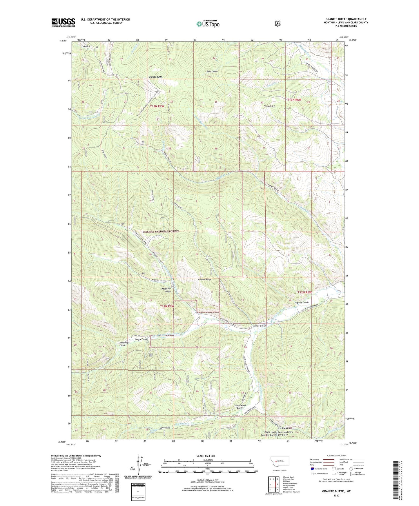
Granite Butte Montana US Topo Map
Couldn't load pickup availability
Also explore the Granite Butte Forest Service Topo of this same quad for updated USFS data
2024 topographic map quadrangle Granite Butte in the state of Montana. Scale: 1:24000. Based on the newly updated USGS 7.5' US Topo map series, this map is in the following counties: Lewis and Clark. The map contains contour data, water features, and other items you are used to seeing on USGS maps, but also has updated roads and other features. This is the next generation of topographic maps. Printed on high-quality waterproof paper with UV fade-resistant inks.
Quads adjacent to this one:
West: Nevada Mountain
Northwest: Swede Gulch
North: Stemple Pass
Northeast: Wilborn
East: Canyon Creek
Southeast: Greenhorn Mountain
South: Esmeralda Hill
Southwest: Ophir Creek
This map covers the same area as the classic USGS quad with code o46112g4.
Contains the following named places: 12N06W32ABDC01 Well, Atlantic City, Beartrap Gulch, Brooks Mine, Cayuse Ridge, Cellar Gulch, Cottonwood Gulch, Crown Mine, Deadman Creek, Dry Gulch, General Robert E Lee Range, Gold Coin Mine, Granite Butte, Granite Butte Lookout Mine, Granite Butte Lookout Tower, Highland Chief Mine, Highland Placer Mine, Highland View Mine, Iron Cliff Mine, Left Hand Fork Deadman Creek, Left Hand Fork Dry Gulch, LKL Number 35 Mine, Lost Horse Creek, McQuithy Gulch, Millersville, Millersville Post Office, NE NW Section 35 Mine, North Fork Little Prickly Pear Creek, North Fork Marsh Creek, NW NW Section 35 Mine, Ogilvie Gulch, Paradise Falls, Pilgeram Ditch, Prize Mine, Queen of the Rosary Church, Right Hand Fork Dry Gulch, Sanford School, SE SE Section 28 Mine, SE SW Section 27 Mine, South Fork Little Prickly Pear Creek, SW NW Section 26 Mine, SW NW Section 36 Mine, SW SE Section 13 Mine, SW SE Section 22 Mine, SW SW Section 17 Mine, SW SW Section 30 Mine, Tongue Gulch