MyTopo
Signal Mountain Montana US Topo Map
Couldn't load pickup availability
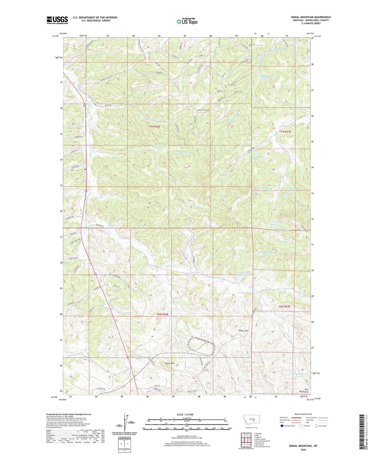
2024 topographic map quadrangle Signal Mountain in the state of Montana. Scale: 1:24000. Based on the newly updated USGS 7.5' US Topo map series, this map is in the following counties: Musselshell. The map contains contour data, water features, and other items you are used to seeing on USGS maps, but also has updated roads and other features. This is the next generation of topographic maps. Printed on high-quality waterproof paper with UV fade-resistant inks.
Quads adjacent to this one:
West: Harper Coulee
Northwest: Roundup
North: Gage
Northeast: Gage NE
East: Dunn Mountain North
Southeast: Dunn Mountain South
South: Park Coulee
Southwest: Hay Basin NE
This map covers the same area as the classic USGS quad with code o46108c4.
Contains the following named places: 06N26E01CDC_01 Well, 06N26E02BD__01 Well, 06N26E02BD__02 Well, 06N26E02DCDA01 Well, 06N26E02DD__01 Well, 06N26E03BCBC01 Well, 06N26E04AB__01 Well, 06N26E10AAD_01 Well, 06N26E10AADA01 Well, 06N26E11CCAD01 Well, 06N26E12AAB_01 Spring, 06N26E12ACDC01 Well, 06N26E13CCAC01 Well, 06N26E14BBAB01 Well, 06N26E16ABAB01 Well, 06N26E22BBBD01 Well, 06N26E22CBAB01 Well, 06N26E22CBAB02 Well, 06N26E23ACCA01 Well, 06N26E23BBCB01 Well, 06N26E23BDDC01 Well, 06N26E24DCAB01 Well, 06N26E24DCAB02 Well, 06N27E06ABC_01 Spring, 06N27E06CAB_01 Spring, 06N27E07ACBC01 Well, 06N27E07CCDC01 Well, 06N27E14BBAA01 Well, 06N27E18BBAB01 Well, 06N27E18DDAD01 Well, 06N27E19CBBB01 Well, 06N27E20BCCC01 Spring, 07N26E08DDAB01 Well, 07N26E09ADDB01 Well, 07N26E10BCCC01 Well, 07N26E10DDB_01 Well, 07N26E12CBAB01 Well, 07N26E14AAC_01 Well, 07N26E14BAD_01 Well, 07N26E14BCDD01 Well, 07N26E14BCDD02 Well, 07N26E15BBCA01 Well, 07N26E17DAAD01 Well, 07N26E20DABB01 Well, 07N26E20DADC01 Well, 07N26E20DCBD01 Well, 07N26E23ACDB01 Well, 07N26E25ACDB01 Well, 07N26E25ADA_01 Spring, 07N26E26BBA_01 Spring, 07N26E27ABA_01 Spring, 07N26E32AA__01 Well, 07N26E32AA__02 Well, 07N26E32DACC01 Well, 07N26E33BBAC01 Well, 07N26E33CDD_01 Well, 07N26E35BBAC01 Well, 07N26E36CCCC01 Well, 07N27E07CA__01 Well, 07N27E07CA__02 Well, 07N27E07CAAC01 Spring, 07N27E08CCDB01 Well, 07N27E18BCA_01 Spring, 07N27E18CCDB01 Well, 07N27E19DBBD01 Well, 07N27E30AAAC01 Well, 07N27E31AAA_01 Spring, 07N27E31ABA_01 Spring, 07N27E31BAA_01 Spring, 07N27E31CDB_01 Spring, Bull Mountain Volunteer Fire Association, Elbow Hill, Rehder Creek, Signal Mountain