
MyTopo
Southwest Great Falls Montana US Topo Map
Couldn't load pickup availability
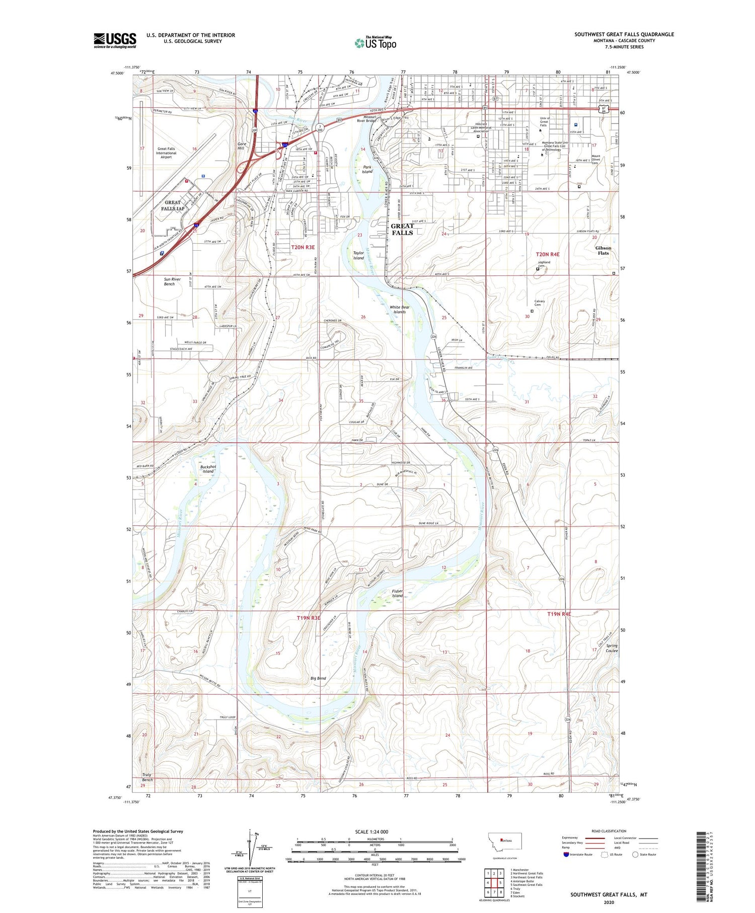
2020 topographic map quadrangle Southwest Great Falls in the state of Montana. Scale: 1:24000. Based on the newly updated USGS 7.5' US Topo map series, this map is in the following counties: Cascade. The map contains contour data, water features, and other items you are used to seeing on USGS maps, but also has updated roads and other features. This is the next generation of topographic maps. Printed on high-quality waterproof paper with UV fade-resistant inks.
Quads adjacent to this one:
West: Antelope Butte
Northwest: Manchester
North: Northwest Great Falls
Northeast: Northeast Great Falls
East: Southeast Great Falls
Southeast: Stockett
South: Eden
Southwest: Truly
Contains the following named places: 19N03E01AABA01 Well, 19N03E01AABA02 Well, 19N03E01ACBB01 Well, 19N03E01DBBB01 Well, 19N03E04BBAD01 Well, 19N03E12CDDA01 Well, 19N03E12DCAC01 Well, 19N03E13BBBB01 Well, 19N03E21BDAB01 Well, 19N03E21DBCD01 Well, 19N03E24CCBD01 Well, 19N04E18A___01 Well, 19N04E18A___02 Well, 19N04E18D___01 Well, 20N03E09CADB01 Well, 20N03E09CADB02 Well, 20N03E09CBDD01 Well, 20N03E09DCDB01 Well, 20N03E13BDDD01 Well, 20N03E13CCAD01 Well, 20N03E13CCCA01 Well, 20N03E13DDCB01 Well, 20N03E13DDDD01 Well, 20N03E20DDAD01 Well, 20N03E21CAAD01 Well, 20N03E21CCCB01 Well, 20N03E21DAAA01 Well, 20N03E22CBDA01 Well, 20N03E23ADAA01 Well, 20N03E23BAAA01 Well, 20N03E24ACAB01 Well, 20N03E24BBAD01 Well, 20N03E25DCAA01 Well, 20N03E25DCAC01 Well, 20N03E26BBBD01 Well, 20N03E26CBBC01 Well, 20N03E26CDAA01 Well, 20N03E26CDCC01 Well, 20N03E27AADA01 Well, 20N03E27ADAC01 Well, 20N03E27BCBB01 Well, 20N03E27DADC01 Well, 20N03E28AACD01 Well, 20N03E28BCCC01 Well, 20N03E28BDDC01 Well, 20N03E28CABB01 Well, 20N03E28CABB02 Well, 20N03E28CBBA01 Well, 20N03E28CBBB01 Well, 20N03E28CBBC01 Well, 20N03E28CBCD01 Well, 20N03E28CCAC01 Well, 20N03E28CCBA01 Well, 20N03E28CCCA01 Well, 20N03E28CCCD01 Well, 20N03E28CDAD01 Well, 20N03E28CDB_01 Well, 20N03E28DDCB01 Well, 20N03E29DDAD01 Well, 20N03E29DDDA01 Well, 20N03E29DDDC01 Well, 20N03E29DDDD01 Well, 20N03E29DDDD02 Well, 20N03E32AAAB01 Well, 20N03E32AADD01 Well, 20N03E32ADDC01 Well, 20N03E35ADCA01 Well, 20N03E36BAAD01 Well, 20N04E18CDAC01 Well, 20N04E18DBBC01 Well, 20N04E19BABB01 Well, 20N04E19BABD01 Well, 20N04E19BDAA01 Well, 20N04E19DBAC01 Well, 20N04E29CCBC01 Well, 20N04E30AABC01 Well, 20N04E31B___01 Well, 20N04E31BCAC01 Well, 20N04E31BCBB01 Well, 20N04E31BCBB02 Well, 20N04E31BCCC01 Well, 20N04E32CCDD01 Well, Abundant Life Christian Fellowship, Advanced Air Network, Bel View Park, Benefit Health System - East Campus Hospital, Benefit Health System - West Campus, Bethel Lutheran Church, Big Bend, Big Bend Fishing Access Site, Broadwater Bay Park, Broadwater Overlook Park, Buckshot Island, Calvary Cemetery, Carter Park, Cascade County Regional Prison, Cascade County Sheriff's Office, Chowen Springs Park, Christ United Methodist Church, Christs Church of Great Falls, Columbia Grain International Incorporated Elevator, Columbus Health Center, Columbus Hospital Heliport, Comer School, Dicks RV Park, Donovan Park, Electric City Lighthouse Church, Emily Hall, Evergreen Mall, Faith Lutheran Church, Falls Yard, First Congregational United Church of Christ, First Southern Baptist Church, Fisher Island, Flood, Flood School, Fox Hollow Park, Gore Hill, Gore Hill Fire Rescue, Grande Vista Park, Great Falls, Great Falls Airport Fire Department, Great Falls Clinic, Great Falls Clinic Medical Center, Great Falls Emergency Services, Great Falls Eye Surgery Center, Great Falls Fire Rescue Station 4, Great Falls International Airport, Great Falls International Airport Police, Great Falls Post Office, Harvest States Cooperatives Elevator, Hebrew Cemetery, Highland Cemetery, Highland South Park, Hillcrest Lawn Memorial Association Columbarium, Holiday Village Mall, Hyland Heights Park, KMON-AM (Great Falls), KQDI-AM (Great Falls), KXGF-AM (Great Falls), Lewis and Clark Statue, Lincoln School, Lions Park, Longfellow School, McLaughlin Center, Meadow Lark Elementary School, Meadowlark Country Club, Meadowlark Park, Metropolitan Community Church, Missouri Meadows Campground, Missouri Meadows Trailer Park, Missouri River Bridge, Missouri River Manor, Montana Deaconess Medical Center Heliport, Montana Deaconess Skilled Nursing Center, Montana Highway Patrol District II Office, Montana Park, Montana State University - Great Falls College of Technology, Mount Olivet Cemetery, Oddfellows Park, Our Lady of Lourdes Church, Palisades Christian School, Park Island, Park Place Health Care Center, Pleasant Park Mobile Home Court, Providence Hall, Reorganized Church of Jesus Christ of Latter-Day Saints, Rivershore Mobile Home Park, Ross School, Salvation Army Church, Sand Coulee Creek, Sand Hills Park, South End Sun River Bridge, South Great Falls, Sun River, Sunnyside Church of God, Sunnyside Park, Sunnyside School, Taylor Island, The Church of Jesus Christ of Latter Day Saints, Trinitas Chapel, Union Bethel African Methodist Episcopal Church, Unity Church of Truth, University of Great Falls, University of Great Falls Library, Valley Community Bible Church, Verde Park, Victory Christian Center, Warden Park, West Hill Park, White Bear Fishing Access Area, White Bear Islands


