MyTopo
Southeast Great Falls Montana US Topo Map
Couldn't load pickup availability
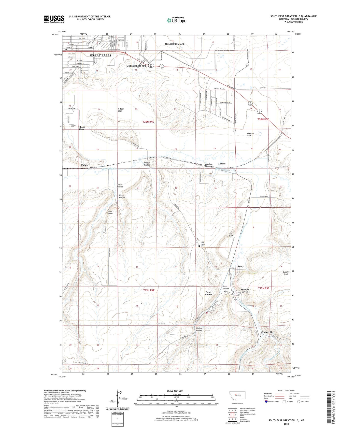
2024 topographic map quadrangle Southeast Great Falls in the state of Montana. Scale: 1:24000. Based on the newly updated USGS 7.5' US Topo map series, this map is in the following counties: Cascade. The map contains contour data, water features, and other items you are used to seeing on USGS maps, but also has updated roads and other features. This is the next generation of topographic maps. Printed on high-quality waterproof paper with UV fade-resistant inks.
Quads adjacent to this one:
West: Southwest Great Falls
Northwest: Northwest Great Falls
North: Northeast Great Falls
Northeast: Morony Dam
East: Fife
Southeast: Mahoney Hill
South: Stockett
Southwest: Eden
This map covers the same area as the classic USGS quad with code o47111d2.
Contains the following named places: 19N04E12A___01 Well, 19N04E13ACCB01 Well, 19N04E14DAAD01 Well, 19N04E14DADB01 Well, 19N05E06C___01 Well, 19N05E06C___02 Well, 19N05E19AACB01 Well, 20N04E13C___01 Well, 20N04E15B___01 Well, 20N04E15DBDD01 Well, 20N04E16AACD01 Well, 20N04E16CCBA01 Well, 20N04E20D___01 Well, 20N04E20DBDC01 Well, 20N04E21____01 Well, 20N04E22B___01 Well, 20N04E25ADAA01 Well, 20N04E25CDDD01 Well, 20N04E25D___01 Well, 20N04E26A___01 Well, 20N04E26A___02 Well, 20N04E26D___01 Well, 20N04E27C___01 Well, 20N04E32A___01 Well, 20N04E32A___02 Well, 20N04E35BCDB01 Well, 20N05E08C___01 Well, 20N05E29ABBC01 Well, 20N05E31C___01 Well, 59472, Agri-Village Shopping Center, Antelope Coulee, Big Stone Colony, Big Stone Colony Census Designated Place, Big Stone School, Centerville, Centerville Census Designated Place, Centerville School, Charles M Russell Post Office, Charles Russell Park, Clara Park, Cottonwood Creek, Dudley Anderson Park, Emmanuel Bible Church, Emmanuel Christian School, Fields, Finn Church, First Alliance Church, Gerber, Gibson Flats, Gibson Flats Census Designated Place, Gobbler Knob, Goon Coulee, Goon Grade, Great Falls KOA Campground, Holy Trinity Catholic Church, Johnson Flats, Lavin, Lewis and Clark Portage Route Historical Marker, Lewis Junction, Lockray, Lockray School, Mining Coulee, Mountain View School, Number Seven, Peace Lutheran Church, Pinski Park, Prill Field, Ranch Strip Airport, Saint Johns Lutheran Church, Saint Pauls Catholic Church, Sand Coulee, Sand Coulee Cemetery, Sand Coulee Census Designated Place, Sand Coulee Hospital, Sand Coulee Post Office, Sand Coulee School, Sand Coulee United Methodist Church, Sand Coulee Volunteer Fire Department, Sand Coulee Volunteer Fire Department Substation, Shack Town School, Spring Coulee, Stainsby, Sunrise Park, Sunrise Presbyterian Church, Tracy, Tracy Census Designated Place, Walker Coulee