MyTopo
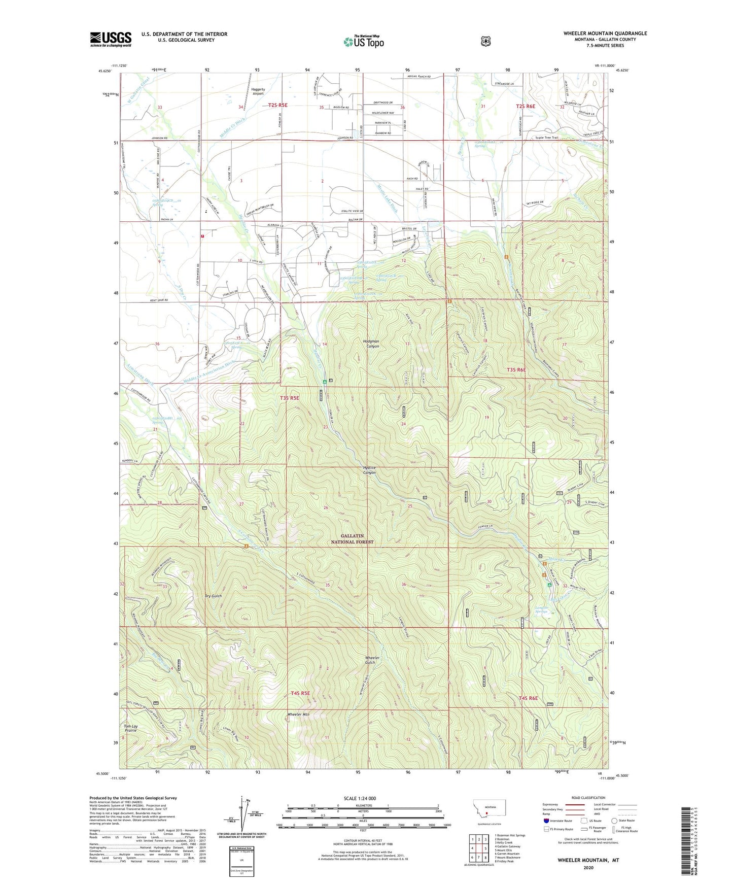
Wheeler Mountain Montana US Topo Map
Couldn't load pickup availability
Also explore the Wheeler Mountain Forest Service Topo of this same quad for updated USFS data
2024 topographic map quadrangle Wheeler Mountain in the state of Montana. Scale: 1:24000. Based on the newly updated USGS 7.5' US Topo map series, this map is in the following counties: Gallatin. The map contains contour data, water features, and other items you are used to seeing on USGS maps, but also has updated roads and other features. This is the next generation of topographic maps. Printed on high-quality waterproof paper with UV fade-resistant inks.
Quads adjacent to this one:
West: Gallatin Gateway
Northwest: Bozeman Hot Springs
North: Bozeman
Northeast: Kelly Creek
East: Mount Ellis
Southeast: Fridley Peak
South: Mount Blackmore
Southwest: Garnet Mountain
This map covers the same area as the classic USGS quad with code o45111e1.
Contains the following named places: 02S05E33CB__01 Well, 02S05E33DB__01 Well, 02S05E33DB__02 Well, 02S05E34CD__01 Well, 02S05E35CB__01 Well, 02S05E35DCDC01 Well, 02S05E35DD__01 Well, 02S05E35DD__02 Well, 02S05E36BACD01 Well, 02S05E36BADD01 Well, 02S05E36DD__01 Well, 02S06E31AD__01 Well, 02S06E31DB__01 Well, 02S06E32CB__02 Well, 03S05E01AC__01 Well, 03S05E01BA__01 Well, 03S05E01DC__01 Well, 03S05E02AD__01 Well, 03S05E02CD__01 Well, 03S05E02DA__01 Well, 03S05E03AB__01 Well, 03S05E03BB__01 Well, 03S05E03DA__01 Well, 03S05E04AAAD01 Well, 03S05E04AB__01 Well, 03S05E04BA__01 Well, 03S05E04CD__01 Spring, 03S05E09AA__01 Well, 03S05E09DA__01 Well, 03S05E10BA__01 Well, 03S05E10BB__01 Well, 03S05E10CCCB01 Well, 03S05E10DB__01 Well, 03S05E11BC__01 Well, 03S05E11DA__01 Spring, 03S05E11DAAC01 Well, 03S05E11DABD01 Well, 03S05E11DDB_01 Spring, 03S05E11DDC_01 Spring, 03S05E12CB__01 Spring, 03S05E15CA__01 Spring, 03S05E15DCCA01 Well, 03S05E16AA__01 Well, 03S05E21AB__01 Well, 03S05E21BBA_01 Well, 03S05E21BBBA01 Well, 03S05E21BBD_01 Well, 03S05E21BD__01 Well, 03S05E21BD__02 Spring, 03S06E05BB__01 Well, 03S06E05CBAA01 Well, 03S06E06AC__01 Well, 03S06E06BA__01 Spring, 03S06E06DA__01 Well, 03S06E06DD__01 Well, 03S06E06DD__02 Well, 59718, Abbot Recreation Site, Anderson School, Buckskin Creek, Dry Gulch, Haggerty Airport, Hodgman Canyon, Hyalite Canyon, Hyalite Station, KBOZ-AM (Bozeman), Langohr Springs, Langohr Springs Campground, Leverich Creek, Leverich School, Middle Creek Association Ditch, Middle Creek Ditch, Moser Creek, Mystic Lake Ditch, Nichols Creek, Sourdough Creek Fishing Access Site, Sourdough Rural Fire District Station 2, Sunshine Mine, West Gallatin Canal, Wheeler Gulch, Wheeler Mountain