MyTopo
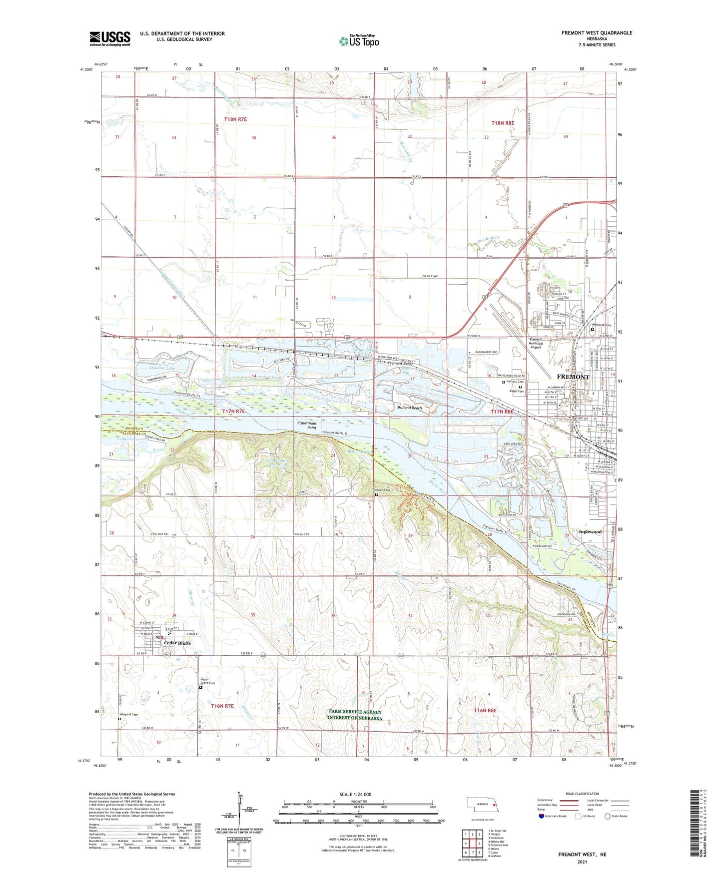
Fremont West Nebraska US Topo Map
Couldn't load pickup availability
2021 topographic map quadrangle Fremont West in the state of Nebraska. Scale: 1:24000. Based on the newly updated USGS 7.5' US Topo map series, this map is in the following counties: Dodge, Saunders. The map contains contour data, water features, and other items you are used to seeing on USGS maps, but also has updated roads and other features. This is the next generation of topographic maps. Printed on high-quality waterproof paper with UV fade-resistant inks.
Quads adjacent to this one:
West: Malmo NW
Northwest: Scribner SW
North: Hooper
Northeast: Nickerson
East: Fremont East
Southeast: Leshara
South: Colon
Southwest: Malmo
Contains the following named places: Ames, Ames Public School, Arbor Manor Living Center, Beaver Lake, Beebe School, Bouer Dam, Bouer Reservoir, Bricks Bay, Calvary Cemetery, Calvary Temple, Camp Calvin Crest, Camp Cedars, Camp Cedars B.S.A Earth Dam, Camp Cedars Reservoir, Camp Christian, Camp Eagle, Cedar Bluffs, Cedar Bluffs Elementary School, Cedar Bluffs Fire Department, Cedar Bluffs Police Department, Cedar Bluffs Post Office, Cedar Lakes, Christensen Field Agricultural Park, Community Christian Church, Cottonwood Cove, Davenport Elementary School, Davenport Park, Emmanuel Baptist Church, Evangelical Wesleyan Church, First Christian Church, First Presbyterian Church, Fishermans Point, Freemont State Recreation Area, Fremont Beach, Fremont Farmers Union Cooperative Association Elevator, Fremont Golf Club, Fremont Lake, Fremont Municipal Airport, Great Platte River Route West Historical Marker, Hay Valley School, Hormel Park, Inglewood, Izaak Walton Park, KFMT-FM (Fremont), Leisure Lake, Linden Elementary School, Louis E May Museum, Main Camp Area, Maple Grove Cemetery, Meadow Lake, Memorial Cemetery, Midland Beach, Midway Trailer Court, Midwest Medical Transport Company Ambulance Service, Miller Park, Milliken Park, Milliken Park Elementary School, Nebraska Railroad Museum, Nenoname 2 Dam, North Camp Area, North Pit, Pathfinder Campground, Pawnee Villages Historical Marker, Platteville Public School, Pohocco Cemetery, Presbyterian Church of Fremont, Rainbow Lake, Ridge Cemetery, Ridgewood Lake, Rivercrest Camp, Riverview School, Ronin Park, Saint Mary Catholic Church, Saint Matthews Lutheran Church, Saint Timothy Lutheran church, Salvation Army Church, School Number 105, South Broad Trailer Court, Summer Haven Lake, Township of North Cedar, Township of Platte, United Pentecostal Church, Valley View Golf Course, Victory Lake, Victory Lake Campground, Village of Cedar Bluffs, Village of Inglewood, Washington Elementary School, Westlake Mobile Home Park, Whitetail Run Golf Course, Wiegand Cemetery, Wildwood Park