MyTopo
Milford Nebraska US Topo Map
Couldn't load pickup availability
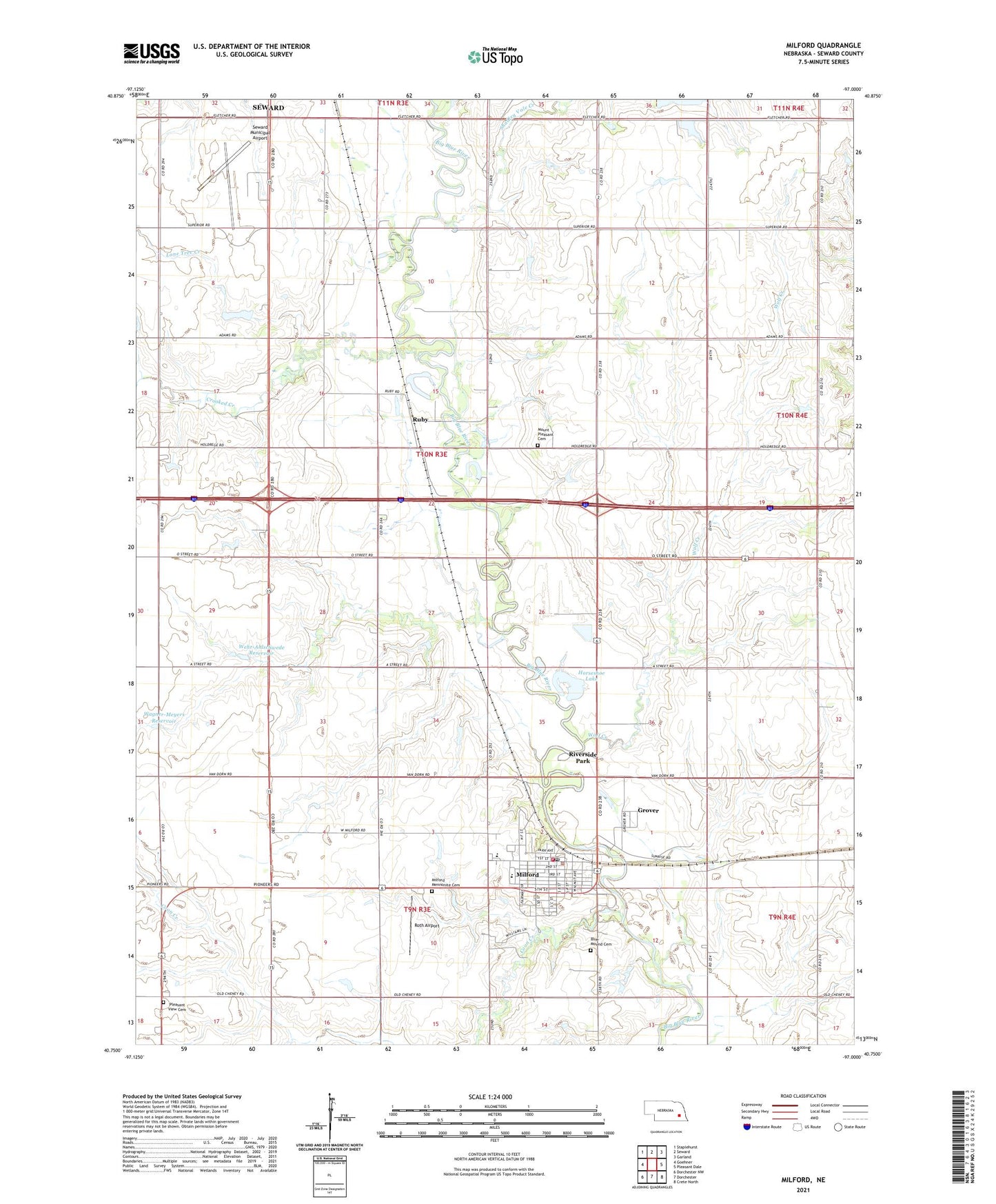
2021 topographic map quadrangle Milford in the state of Nebraska. Scale: 1:24000. Based on the newly updated USGS 7.5' US Topo map series, this map is in the following counties: Seward. The map contains contour data, water features, and other items you are used to seeing on USGS maps, but also has updated roads and other features. This is the next generation of topographic maps. Printed on high-quality waterproof paper with UV fade-resistant inks.
Quads adjacent to this one:
West: Goehner
Northwest: Staplehurst
North: Seward
Northeast: Garland
East: Pleasant Dale
Southeast: Crete North
South: Dorchester
Southwest: Dorchester NW
This map covers the same area as the classic USGS quad with code o40097g1.
Contains the following named places: Arrival Sculpture, Assembly of God Church, Bellwood Mennonite Church, Beth-El Mennonite Church, Big Blue River Historical Marker, Blue Mound Cemetery, Blue River Rest Area, Camp Kiwanis, City of Milford, Coon Creek, Cornhusker Hall, Countryside Co-op Elevator, Crooked Creek, Dorchester Farmers Cooperative Elevator, East Fairview Church, Eicher Technical Center, Election Precinct J, Good Shepherd Lutheran Church, Grover, Grover Post Office, Hackbart Chiropractic Center, Horseshoe Lake, Industry Training Center, Integrated Health Services, Lone Tree Creek, Maintenance Building, Milford, Milford Dental Clinic, Milford Elementary School, Milford Family Medical Center, Milford High School, Milford Mennonite Cemetery, Milford Police Department, Milford Post Office, Milford Volunteer Fire and Rescue Station, Missionary Church, Mount Pleasant Cemetery, Nebraska Hall, Pioneer Complex, Pleasant View Cemetery, Presidents Home, Riverside Park, Roth Airport, Ruby, Ruby Co-op Company Elevator, Ruby Post Office, Saint Gregory the Great Seminary, Saint Paul Church, Seward Municipal Airport, Shadley Vale Creek, South Park, Southeast Community College - Milford Campus, Stanley A Matzke Library, Sunrise Country Manor, Thornridge Golf Course, Township J, United Methodist Church, Uptown Park, Wagner-Meyers Reservoir, Wagner-Meyers Road Dam, Webermeier Memorial Library, Wehr-Ahlschwede Reservoir, Wehr-Ahlschwede Road Dam, Welch Park, Welsh Center Gymnasium and Student Center, Westward Ho! Campground, Wolf Creek, ZIP Code: 68405