MyTopo
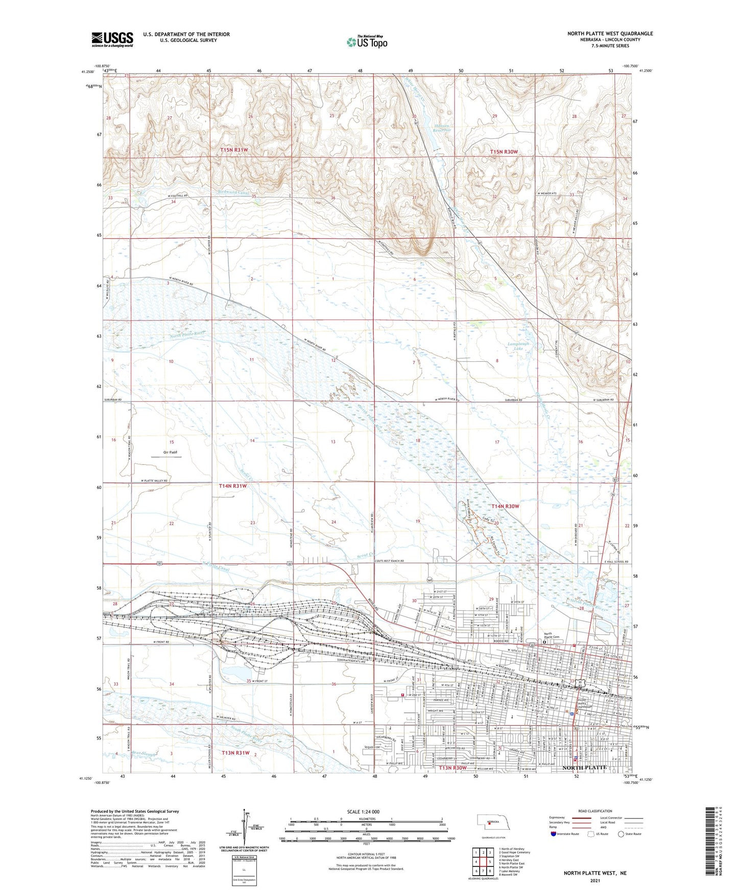
North Platte West Nebraska US Topo Map
Couldn't load pickup availability
2021 topographic map quadrangle North Platte West in the state of Nebraska. Scale: 1:24000. Based on the newly updated USGS 7.5' US Topo map series, this map is in the following counties: Lincoln. The map contains contour data, water features, and other items you are used to seeing on USGS maps, but also has updated roads and other features. This is the next generation of topographic maps. Printed on high-quality waterproof paper with UV fade-resistant inks.
Quads adjacent to this one:
West: Hershey East
Northwest: North of Hershey
North: Good Hope Cemetery
Northeast: Stapleton SW
East: North Platte East
Southeast: Maxwell SW
South: Lake Maloney
Southwest: North Platte SW
This map covers the same area as the classic USGS quad with code o41100b7.
Contains the following named places: A-1 Sunset Mobile/RV Park, Adams Middle School, Aspen Park Retirement and Assisted Living, Baha'i Faith, Beautiful Savior Lutheran Church, Berean Fundamental Church, Bethel Evangelical Free Church, Bill Wood Field, Buffalo Bill Ranch State Park, Buffalo Bill State Recreation Area, Buffalo Bill Trail, Buffalo Bill Wild West Rodeo Arena, Buffalo Elementary School, Calvary Assembly of God Church, Camp Sergeant, Christian Science Society, Church of Christ, City of North Platte, Cleveland School, Cody Elementary School, Cody Park, Cody Park Campground, Cody Park Railroad Museum, Craft State Office Building, Eisenhower Elementary School, Eisenhower Park, Episcopal Church of Our Savior, First Assembly of God Church, First Baptist Church, First Christian Church, First Church of God, First Evangelical Lutheran Church, First Presbyterian Church, First United Methodist Church, Fort McPherson Historical Marker, Green Acres Trailer Court, Hansen Dam, Hansen Reservoir, Hinman Election Precinct, Holy Spirit Catholic Community Church, Jefferson Elementary School, Jehovahs Witnesses Kingdom Hall, Jim Carpernter Memorial Men/Women Softball Complex, Jorgensen Chiropractic Care, Key Estates, KJLT-FM (North Platte), KODY-AM (North Platte), KOOQ-AM (North Platte), Kriz Park, Lamplaugh Lake, Lincoln County Courthouse, Lincoln County Fairgrounds, Lincoln County Historical Society Western Heritage Museum, Lincoln County Sheriff's Office, Lincoln Elementary School, Linden Manor Nursing Home, Love Ministries, Madison Middle School, McDaid Elementary School, McDonald Elementary School, McKinley School, Memorial Hospital, Memorial Park, Messiah Lutheran Church, Mobile Manor, Neville Center for the Performing Arts, North Platte, North Platte Care Centre, North Platte Cemetery, North Platte Church of the Nazarene, North Platte Country Club, North Platte Election Precinct, North Platte Fire Department Station 1, North Platte Fire Department Station 2, North Platte Fire Department Station 3, North Platte High School, North Platte Plaza, North Platte Police Department, North Platte Public Library, Orabella Park, Orr Field, Pawnee Retirement Hotel, Platte Valley Christian Academy, Regency Retirement Residence, Reorganized Church of Jesus Christ of Latter Day Saints, Restoration Branch of Jesus Church, Roosevelt School, Saint Marys Hospital, Saint Patricks Catholic Church, Saint Patricks High School, Saint Paul Evangelical Lutheran Church, Salvation Army Church, Schufeldt Chiropractic Clinic, Scout Creek, Scouts Rest Historical Markers, Sioux View Park, Soul Harbor Church of God, Spanish Assembly of God Church, Taft School, The Church of Jesus Christ of Latter Day Saints, The Learning Center, Tri States Trailer Court, Union Pacific Bailey Yard and Information Center, United Pentecostal Church, Village Square, Washington Elementary School, Wayne Dowhower Memorial Softball Complex for Girls, Wesleyan Church, West End Chapel, Westfield Foursquare Gospel Church, Westfield Shopping Center, ZIP Code: 69101