MyTopo
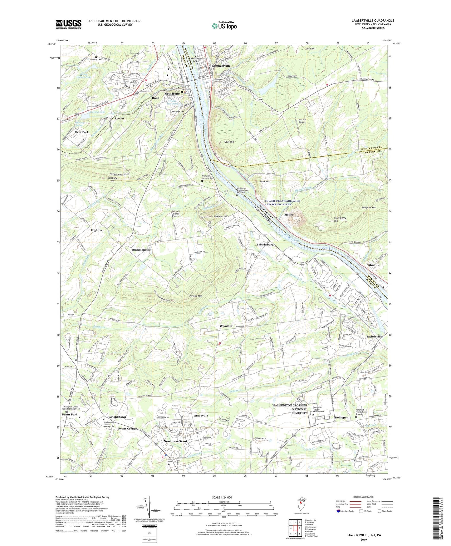
Lambertville New Jersey US Topo Map
Couldn't load pickup availability
2023 topographic map quadrangle Lambertville in the states of Pennsylvania, New Jersey. Scale: 1:24000. Based on the newly updated USGS 7.5' US Topo map series, this map is in the following counties: Hunterdon, Bucks, Mercer. The map contains contour data, water features, and other items you are used to seeing on USGS maps, but also has updated roads and other features. This is the next generation of topographic maps. Printed on high-quality waterproof paper with UV fade-resistant inks.
Quads adjacent to this one:
West: Buckingham
Northwest: Lumberville
North: Stockton
Northeast: Hopewell
East: Pennington
Southeast: Trenton West
South: Langhorne
Southwest: Hatboro
Contains the following named places: All Saints Cemetery, Anchor Crossing Shopping Center, Anchor Estates, Aquetong Creek, Aquetong Lake, Aquetong Spring, Belle Mountain, Blue Anchor, Borough of New Hope, Bowman Hill, Bowmens Tower, Brightwood Farms, Brownsburg, Brownsburg Post Office, Buckland Valley Farms, Buckland Valley Farms East Grant, Buckmanville, Cedar Glen, City of Lambertville, Corn Hill, Curls Run, Dark Hollow Run, Deer Park, Dolington, Dolington Post Office, Fairfield School, Fiddlers Creek, Fire Creek Acres, Fleetwing Fire Station, Glen Ashton, Goat Hill, Goat Hill Airport, Good Intent School, Highton, Holcombe Island, Holiday Inn of New Hope Airport, Honey Hollow Pond, Hood, Huffnagle, Hunterdon Christian Academy School, Hunters Hill Farm Airport, Ingham Creek Dam, Ingham Mews, Ingham Spring, Jarman Airport, Jericho Creek, Jericho Mountain, Jesus School, King Ranch, Lambertville, Lambertville Elementary School, Lambertville Fire Department Columbia Fire Company 4, Lambertville Fire Department District 1, Lambertville Fire Department Fleetwing Hook and Ladder Company 3, Lambertville Fire Department Hibernia Company 2, Lambertville Post Office, Makefield Friends Burial Grounds, Mercer County Correctional Center, Mercer County Park, Miberna Fire Station, Moore, Moores Creek, Moore's Station Quarry, Mount View Estates, Neshaminy Cliffs, New Hope, New Hope Boro Chamber of Commerce, New Hope Boro Hall, New Hope Boro Information Center, New Hope Boro Post Office, New Hope Cemetery, New Hope Centers, New Hope Eagle Fire Company Station 46, New Hope Hills, New Hope Police Department, New Hope Post Office, New Hope Shopping Center, New Hope Solebury High School, New Hope Station, New Hope-Soelbury Middle School, New Hope-Solebury School Board, Newtown Elementary School, Newtown Emergency Services, Newtown Friends Church, Newtown Grant, Newtown Grant Census Designated Place, Newtown Township Building, Newtown Township Police Department, Penns Park, Penns Park Post Office, Penns Park United Methodist Church, Penns Park United Methodist Church Cemetery, Pidcock Creek, Reeder, Ryans Corner, Saint Andrews Catholic School, Saint Martin of Tours Cemetery, Saint Martins Church, Shires Crossing, Sol Feinstone Elementary School, Solebury Farm Dam, Solebury Friends Graveyard, Solebury Mountain, Solebury Mountain Estates, Stoopville, Strawberry Hill, Sunny Knolls, Swan Creek, Taylorsville, The Studio for Experiential Learning School, The Titusville Academy, Thompson Memorial Cemetery, Thompson Neely House, Timber Ridge, Titusville, Titusville Census Designated Place, Township of Upper Makefield, Township of Wrightstown, Upper Makefield Fire Company Station 71, Upper Makefield Fire Company Station 81, Upper Makefield Police Station, Upper Makefield Township Police Department, Van Sant Covered Bridge, Village II, Village of Logan Square Shopping Center, Village Two Dam, Village Two Pond, Washington Crossing Dam, Washington Crossing Historic Park, Washington Crossing National Cemetery, Washington Crossing State Park Cemetery, Washington Meadows, West Amwell Fire Company Station 26 - 2, Windy Bush Hills, Wood Hill Farms, Woodhill, Woodlawn Acres, Woodsedge Farms, Wrenwood, Wrightstone Elementary School, Wrightstown, Wrightstown Friends Meeting Cemetery, Wrightstown Post Office, Wrightstown Township Police Station, Yorkshire Meadows, ZIP Codes: 08530, 18938, 18940, 18977