MyTopo
Buckingham Pennsylvania US Topo Map
Couldn't load pickup availability
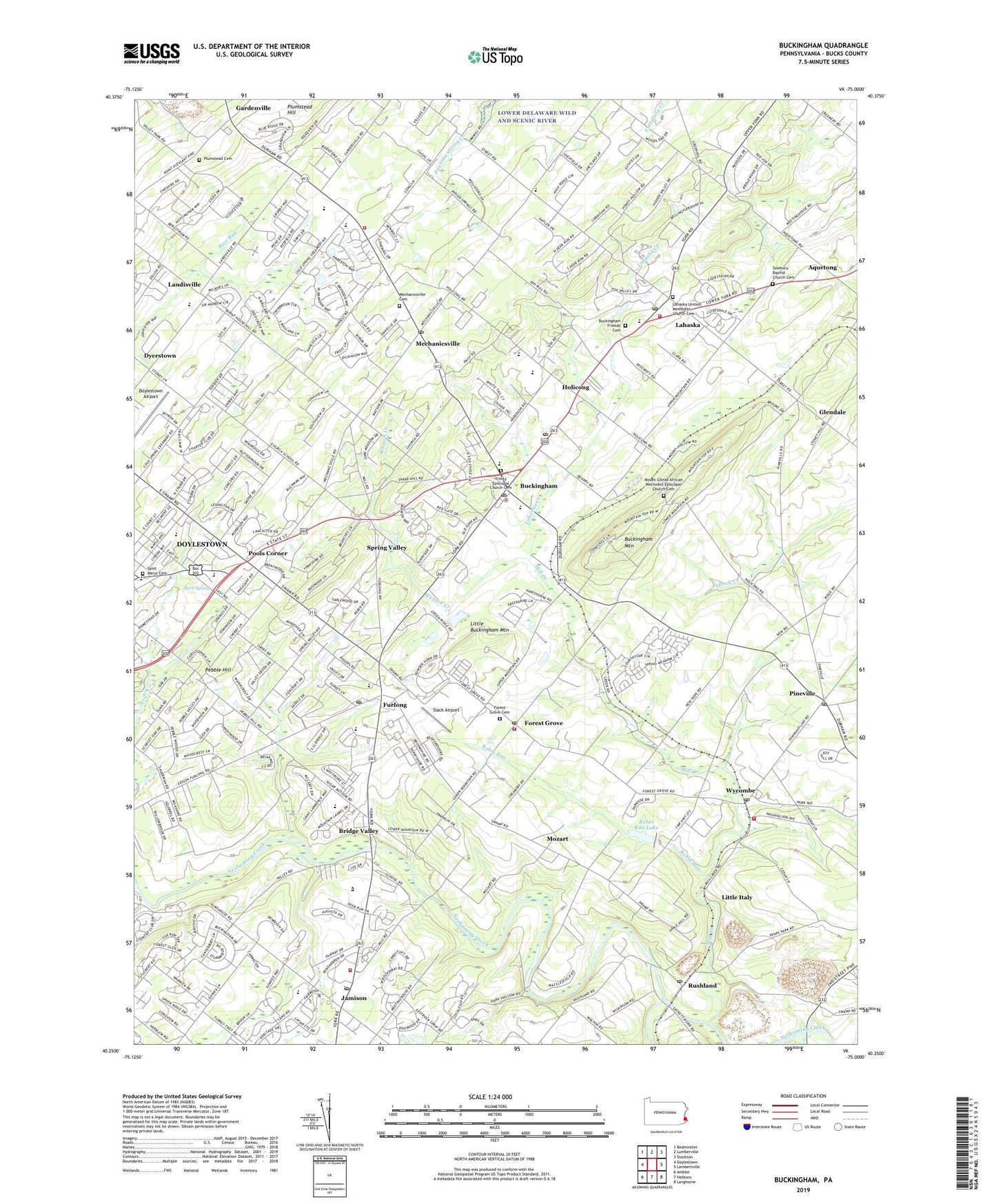
2023 topographic map quadrangle Buckingham in the state of Pennsylvania. Scale: 1:24000. Based on the newly updated USGS 7.5' US Topo map series, this map is in the following counties: Bucks. The map contains contour data, water features, and other items you are used to seeing on USGS maps, but also has updated roads and other features. This is the next generation of topographic maps. Printed on high-quality waterproof paper with UV fade-resistant inks.
Quads adjacent to this one:
West: Doylestown
Northwest: Bedminster
North: Lumberville
Northeast: Stockton
East: Lambertville
Southeast: Langhorne
South: Hatboro
Southwest: Ambler
This map covers the same area as the classic USGS quad with code o40075c1.
Contains the following named places: Amadon, Anchor Presbyterian Church, Aquetong, Bennetts Corner, Blueberry Hill, Bridge Valley, Bridge Valley Heights, Bridge Valley Post Office, Buckingham, Buckingham Airport, Buckingham Elementary School, Buckingham Friends Cemetery, Buckingham Friends Meeting, Buckingham Friends School, Buckingham Green Shopping Center, Buckingham Mountain, Buckingham Post Office, Buckingham School, Buckingham Shopping Center, Buckingham Township Administered Municipal Building, Buckingham Township Hall, Buckingham Township Police Department, Buckingham Valley, Buckingham Valley Post Office, Buckingham Valley Rehabilitation Nursing Center, Buckingham Valley Station, Bucks County, Bucks County Country Club, Bucks County Visitor Center, Buckshire Valley, Buttonwood Glen, Bycot Station, Carvers Run, Centerville, Central Bucks High School East, Clemens Farms, Cold Spring Elementary School, Community Dam, Convenant Presbyterian Church, Cranberry Hill, Creeklyn, Curiosity Shoppe, Curiosity Shoppe School, Cuttalosa Creek, Dark Hollow, Doylestown Airport, Doylestown Country Club, Doylestown Country Club Golf Course, Doylestown United Methodist Church, Duane Village, Durham Lea, Durham Village, Dyerstown, Eastbrook, Eureka, Fairview, Family of God Lutheran Church, First Baptist Church of Wycombe, Five Points, Font Hill County Park, Fonthill Museum, Forest Grove, Forest Grove Cemetery, Forest Grove Post Office, Forest Grove Presbyterian Church, Fox Croft, Friendship School, Furlong, Furlong Chapel, Furlong Post Office, Gardenville, Gardenville School, Glen Elna Farm, Glendale, Golfview, Heritage Creek Estates, Holicong, Holicong Middle School, Holicong Post Office, Honey Hollow, Hunters Run, Jamison, Jamison Elementary School, Jamison Park, Jamison Post Office, Keeble Acres, Kerr Spring, Kinder Works of Doylestown, Kingdom Hall Jehovahs Witness, Lahaska, Lahaska Creek, Lahaska Post Office, Lahaska Station, Lahaska United Methodist Church Cemetery, Landisville, Lighthouse Baptist Church, Linden Elementary School, Lingohocken Fire Company Station 35, Lingohocken Fire Company Station 95, Little Buckingham Mountain, Little Buckingham Mountain Estates, Little Italy, Little Neshaminy Creek, Maplewood, Mechanics Valley, Mechanicsville, Mechanicsville Cemetery, Mechanicsville Post Office, Meyer Airport, MIddle Bucks Institute of Technology, Middle Bucks Vocational Technical School, Midway Company 5 Fire Station, Midway Volunteer Fire Company - Station 13, Midway Volunteer Fire Company Station 15, Midway Volunteer Fire Company Station 5, Mill Creek, Montessori School, Mount Gilead African Methodist Episcopal Church Cemetery, Mount Giliead African Methodist Episcopal Church, Mountain View, Mozart, Octagonal Schoolhouse, Old Mill Estates, Old Orchard Farm, Orchard Valley, Our Lady of Mount Carmal Catholic School, Our Lady of Mount Carmel Church, Our Lady of Mount Carmel Elementary School, Pebble Hill, Pebble Hill Acres, Pebble Hill Church, Pebble Hill Streams, PECO Energy Electric Substation, Peddlers Village Shopping Center, Pennwood Farm Airport, Pheasant Ridge, Pheasant Run, Pickwick of Pebble Hill School, Pineville, Pineville Community Chapel, Pineville Post Office, Pleasant Ridge Church of Danboro, Plumstead Friends Meeting, Plumstead Friends Meeting Cemetery, Plumstead Hill, Pools Corner, Red Fox Farms, Red Gate Farm, Redeemer Lutheran Church, Ridge Valley, Robin Run, Robin Run Dam, Robin Run Lake, Rushland, Rushland Post Office, Saint Cyril of Jerusalem Church, Saint Marys Cemetery, Samuel Farms, Skyron Aero Industrial Park, Slack Airport, Solebury Baptist Church Cemetery, Solebury Church, Solebury Farms Estates, Soviegn Estates, Spring Hill, Spring Valley, Stanwood Farms, Sunnyside Acres, Temple Judea, Township of Buckingham, Township of Solebury, Township of Warwick, Trinity Episcopal Church, Trinity Episcopal Church Cemetery, Turk Dam, United Methodist Church of Lahaska, Valley View Village, Warwick Company 66 Fire Station, Warwick Square Shopping Center, Warwick Township Fire Company Station 66, Warwick Township Public Works Building, Watson Creek, Wellington Estates, West Hunt, Winchester Park, Woodbrook Estates, Woodfield, Woodhill, Woods of Pebble Hill, Woodstream West, Wrightstown School, Wycombe, Wycombe Post Office, Yorkshire Estates, ZIP Codes: 18902, 18912, 18925, 18929, 18980