MyTopo
Marmora New Jersey US Topo Map
Couldn't load pickup availability
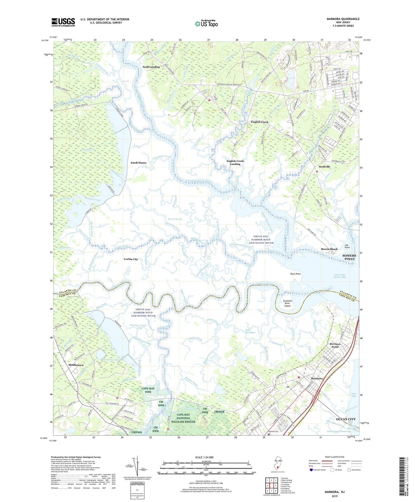
2023 topographic map quadrangle Marmora in the state of New Jersey. Scale: 1:24000. Based on the newly updated USGS 7.5' US Topo map series, this map is in the following counties: Atlantic, Cape May. The map contains contour data, water features, and other items you are used to seeing on USGS maps, but also has updated roads and other features. This is the next generation of topographic maps. Printed on high-quality waterproof paper with UV fade-resistant inks.
Quads adjacent to this one:
West: Tuckahoe
Northwest: Dorothy
North: Mays Landing
Northeast: Pleasantville
East: Ocean City
Southeast: Sea Isle City OE E
South: Sea Isle City
Southwest: Woodbine
This map covers the same area as the classic USGS quad with code o39074c6.
Contains the following named places: Abrams Creek, Asbury Church, Atlantic Christian School, Babcock Creek, Banks Creek, Beesleys Point, Beesleys Point Census Designated Place, Ben Elders Creek, Big Greaves Creek, Bog Branch Creek, Bridge Creek, Cedar Hammocks Creek, Cedar Swamp Creek, Charley Creek, City of Corbin City, Commando Creek, Cranberry Creek, E H Slaybaugh School, English Creek, English Creek Landing, English Creek Pond, English Creek Pond Dam, Flat Creek, Gibson Creek, Gibson Landing, Going Through Creek, Great Egg Harbor River, Griscom Creek, Griscom Swamp, Ground Creek, H Russel Smith School, Halfway Creek, Hawkins Creek, Hubbard Race Creek, Hughes Creek, Jackson Creek, Jacobs Creek, Jeffers Landing, Job Creek, Job Point, Lakes Creek, Landing Creek, Little Greaves Creek, Long Point Creek, Lower Brothers Creek, Ludlam Creek, Marmora, Marmora Census Designated Place, Marmora Post Office, Marmora Volunteer Fire Company, Masons Creek, Mathews Run, Middle River, Middletown, Mill Creek, Miller Creek, Mirey Run, Morris Beach, Mosquito Landing, Mud Creek, Narrows Creek, Nell Run, Otter Creek, Oyster Creek, Palermo Church, Palestine Church, Patcong Creek, Peters Creek, Petersburg, Powell Creek, Rock Point, Schooner Creek, Scull Landing, Scullville, Scullville Volunteer Fire Company 3, Scullville Volunteer Fire Company 3 Station 2, Seaside Cemetery, Sedge Creek, Slaybaugh School, Sluice Creek, Smith School, Stephen Creek, Swan Pond, Swan Pond Race, Township Middle School, Township of Upper, Township School, Trinity Church, Tuckahoe Census Designated Place, Tuckahoe Dam, Tuckahoe Lake, Tuckahoe River, Tuckahoe River Island, Tuckahoe-Corbin City Fish and Wildlife Management Area, Turtle Ground Creek, Upper Brothers Creek, Upper Township Elementary School, Upper Township Rescue Squad, Wesley Church, Willis Thorofare, ZIP Code: 08223