MyTopo
Mays Landing New Jersey US Topo Map
Couldn't load pickup availability
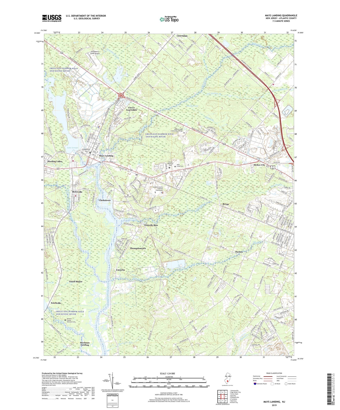
2023 topographic map quadrangle Mays Landing in the state of New Jersey. Scale: 1:24000. Based on the newly updated USGS 7.5' US Topo map series, this map is in the following counties: Atlantic. The map contains contour data, water features, and other items you are used to seeing on USGS maps, but also has updated roads and other features. This is the next generation of topographic maps. Printed on high-quality waterproof paper with UV fade-resistant inks.
Quads adjacent to this one:
West: Dorothy
Northwest: Newtonville
North: Egg Harbor City
Northeast: Green Bank
East: Pleasantville
Southeast: Ocean City
South: Marmora
Southwest: Tuckahoe
This map covers the same area as the classic USGS quad with code o39074d6.
Contains the following named places: Adams Branch, Alder Avenue Middle School, Anthony Tony Canale Fire Training Center, Atlantic Blueberry Company Airstrip, Atlantic City Racetrack, Atlantic Community College, Atlantic County, Atlantic County Adult Education School, Atlantic County Court House, Atlantic County Institute of Technology, Atlantic County Park, Atlantic County Sheriff's Office Mays Landing, Atlantic County Special Elementary School, Atlantic County Special High School, Atlantic County Veterans Cemetery, Babcock Creek, Babcock Swamp, Belcoville, Belcoville Volunteer Fire Company, Catawba, Cedar Branch, Clarkstown, Clover Leaf Lakes, Cologne Volunteer Fire Company 5, Davis Field, Dr Joy D Miller Elementary School, Dry Run, Egg Harbor Township High School, English Creek Census Designated Place, Estell Manor, Estellville, George L Hess Educational Complex Elementary School, Gerald L Gormley Justice Facility, Gravelly Run, Hamilton Township Rescue Squad, High Bank Landing, Holy Cross Cemetery, Jack Pudding Branch, Joseph C Shaner Memorial Elementary School, Lake Lenape, Lake Lenape Dam, Lakewood Chapel, Laureldale, Lighthouse at Mays Landing, Lincoln Memorial Park, Man Killer Branch, Mays Landing, Mays Landing Census Designated Place, Mays Landing Post Office, Mays Landing Volunteer Fire Company Station 18 - 1, McKee City, McKee City Census Designated Place, Miry Run, Mount Pleasant Church, Oakcrest High School, Ocean Heights Church, Perch Cove Run, Pine Oak Park, Pleasant Valley Farm, Presbyterian Cemetery, Reega, Saint Vincent de Paul Regional School, South River, Steelman Landing, Stephen Lake Dam, Strawberry Fields Airport, Thelma, Thompsontown, Township of Hamilton, Township of Hamilton Police Department, Union Cemetery, Watering Race Branch, William Davies Middle School, Wilsons Landing, ZIP Code: 08330