MyTopo
Angus New Mexico US Topo Map
Couldn't load pickup availability
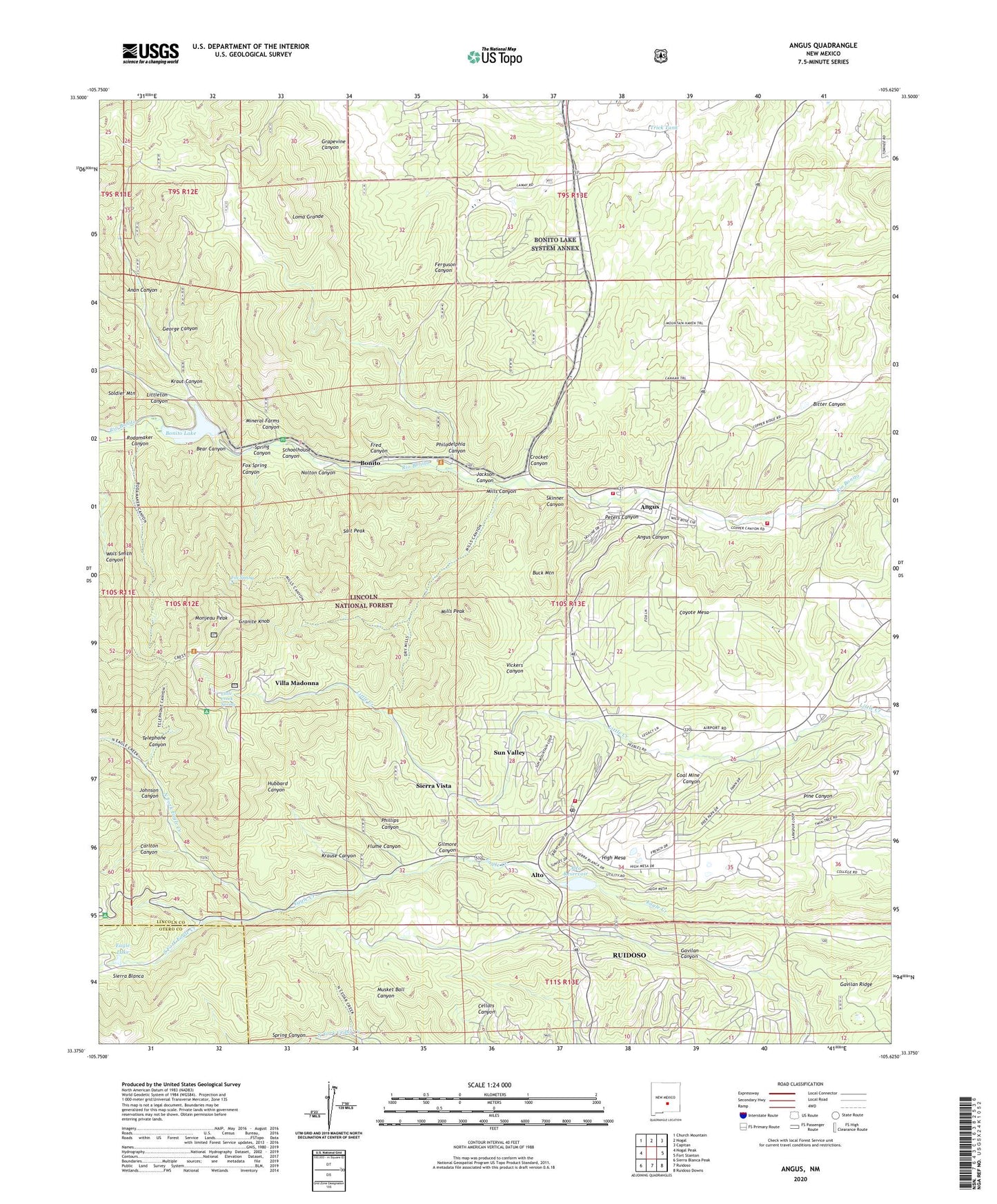
2020 topographic map quadrangle Angus in the state of New Mexico. Scale: 1:24000. Based on the newly updated USGS 7.5' US Topo map series, this map is in the following counties: Lincoln, Otero. The map contains contour data, water features, and other items you are used to seeing on USGS maps, but also has updated roads and other features. This is the next generation of topographic maps. Printed on high-quality waterproof paper with UV fade-resistant inks.
Quads adjacent to this one:
West: Nogal Peak
Northwest: Church Mountain
North: Nogal
Northeast: Capitan
East: Fort Stanton
Southeast: Ruidoso Downs
South: Ruidoso
Southwest: Sierra Blanca Peak
Contains the following named places: Alto, Alto Lake Dam, Alto Post Office, Alto Reservoir, Anan Canyon, Angus, Angus Canyon, Bear Canyon, Bonito, Bonito Dam, Bonito Lake, Bonito Post Office, Bonito Volunteer Fire Department - Angus Canyon Station, Bonito Volunteer Fire Department - Copper Canyon Station, Bonito Volunteer Fire Department Sun Valley Station, Buck Mountain, Carlton Canyon, Cedar Creek Trail, Christmas, Church of the Nazarene, Coal Mine Canyon, Coyote Mesa, Creek Lead Claim, Crest Trail, Crocket Canyon, Divine Guidance Number Two, Dry Mills Trail, Eagle Creek Lodge, Eagle Lake, Ferguson Canyon, Flume Canyon, Fox Spring, Fox Spring Canyon, Fred Canyon, Gavilan Ridge, George Canyon, Gilmore Canyon, Granite Knob, Grapevine Canyon, High Mesa, Hope Prospect, Hubbard Canyon, Jackson Canyon, Johnson Canyon, Krause Canyon, Kraut Canyon, KWES-FM (Ruidoso), Lamay Ranch, Little Creek Spring, Littleton Canyon, Loma Grande, Loma Grande Ranch, Mayberry Mine, McCrory Prospect, Mills Canyon, Mills Peak, Mineral Farm Prospect, Mineral Farms Canyon, Monjeau Campground, Monjeau Lookout, Monjeau Number 1 Claim, Monjeau Peak, Nolton Canyon, North Eagle Trail, North Fork Eagle Creek, Oak Grove Campground, Oso Claim, Peters Canyon, Philadelphia Canyon, Phillips Canyon, Rock Number One, Rodamaker Canyon, Ruidoso Reservoir, Salt Peak, Schoolhouse Canyon, Sierra Vista, Silver Plume Mine, Skinner Canyon, Skyline Campground, Soldier, South Fork Eagle Creek, Spring Canyon, Sun Valley, Telephone Canyon, The Church of Latter Day Saints, Trick Tank, Vickers Canyon, Villa Madonna, Water Dog Prospect, Wet Mills Trail, Yours Truly Claim, ZIP Code: 88312