MyTopo
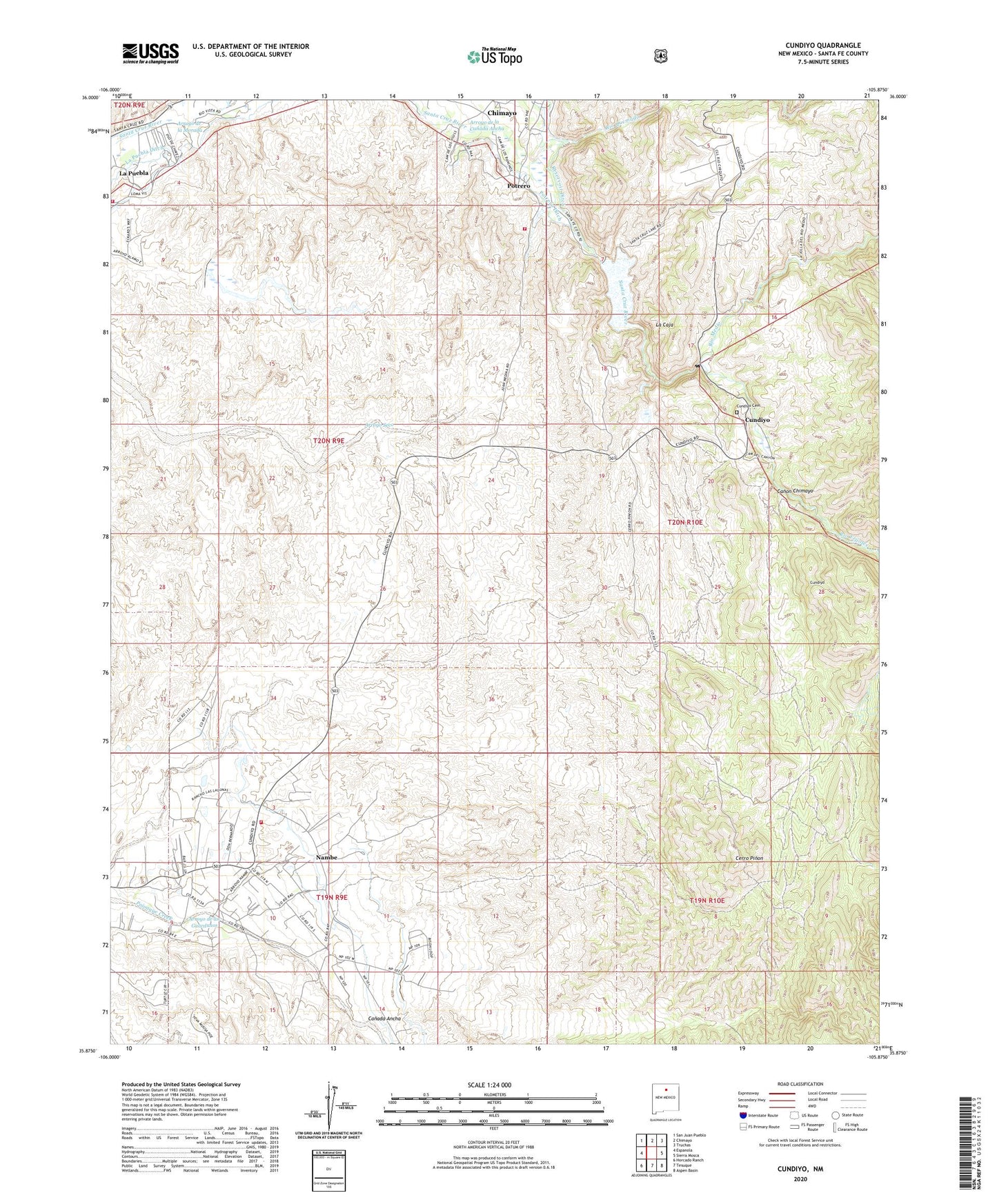
Cundiyo New Mexico US Topo Map
Couldn't load pickup availability
Also explore the Cundiyo Forest Service Topo of this same quad for updated USFS data
2023 topographic map quadrangle Cundiyo in the state of New Mexico. Scale: 1:24000. Based on the newly updated USGS 7.5' US Topo map series, this map is in the following counties: Santa Fe. The map contains contour data, water features, and other items you are used to seeing on USGS maps, but also has updated roads and other features. This is the next generation of topographic maps. Printed on high-quality waterproof paper with UV fade-resistant inks.
Quads adjacent to this one:
West: Espanola
Northwest: San Juan Pueblo
North: Chimayo
Northeast: Truchas
East: Sierra Mosca
Southeast: Aspen Basin
South: Tesuque
Southwest: Horcado Ranch
This map covers the same area as the classic USGS quad with code o35105h8.
Contains the following named places: 10170 Water Well, 10183 Water Well, 10184 Water Well, 10186 Water Well, 10194 Water Well, 10257 Water Well, Arroyo de la Canada Ancha, Arroyo de la Morada, Arroyo de los Guardunos, Arryo Seco Water Well, BLM Recreation Site, Boy Scouts of America Chimayo Rest Camp, Camp Frank Rand Boy Scout Camp, Canada Ancha, Canon Chimayo, Capilla de Santo Domingo Church, Cerro Pinon, Chimayo Boy Scout Camp, Chimayo Census Designated Place, Cundiyo, Cundiyo Cemetery, Cundiyo Census Designated Place, Cundiyo Post Office, El Buen Pastor Church, El Santuario Church National Historic Landmark, Escondillo, EWCH 2 Water Well, Gilliland Claims, Hubbard Prospect, John Hyson School, Kel Fed 1 Water Well, KIOT-FM (Espanola), La Caja, La Capilla de Nacimiento del Nino Dios Church, La Puebla, La Puebla Ditch, Marion, Nambe, Nambe Census Designated Place, Nambe ECW1 Water Well, Nambe Indian School, Nambe Post Office, Nambe Pueblo, Nambe Pueblo Grant, Northlake Campground, Overlook Campground, Potrero, Potrero Ditch, Pueblo of Nambe Historical Marker, Reservoir Ditch, RG-14204 Water Well, RG-16849 Water Well, RG-18448 Water Well, RG-20351 Water Well, RG-2182 Water Well, RG-22935 Water Well, RG-23784 Water Well, RG-25071 Water Well, RG-26557 Water Well, RG-9327 Water Well, Rio Chiquito Census Designated Place, Rio Frijoles, Rio Medio, Rio Quemado, Sacred Heart Church, Saint Dominic Church, San Antonio de la Ladera Church, San Francisco de Assisi Church, Santa Cruz Debris Basin Number 101 Dam, Santa Cruz Grant, Santa Cruz Lake, Santa Cruz Reservoir Dam, Santa Fe County Volunteer Fire Chimayo District, Santa Fe County Volunteer Fire Department District - Station 2 Pojoaque, Santa Fe County Volunteer Fire Department la Puebla District Station 1, Santo Domingo De Cundiyo Grant, Santo Nino Church, Sierra Mosca Trail