MyTopo
Espanola New Mexico US Topo Map
Couldn't load pickup availability
Also explore the Espanola Forest Service Topo of this same quad for updated USFS data
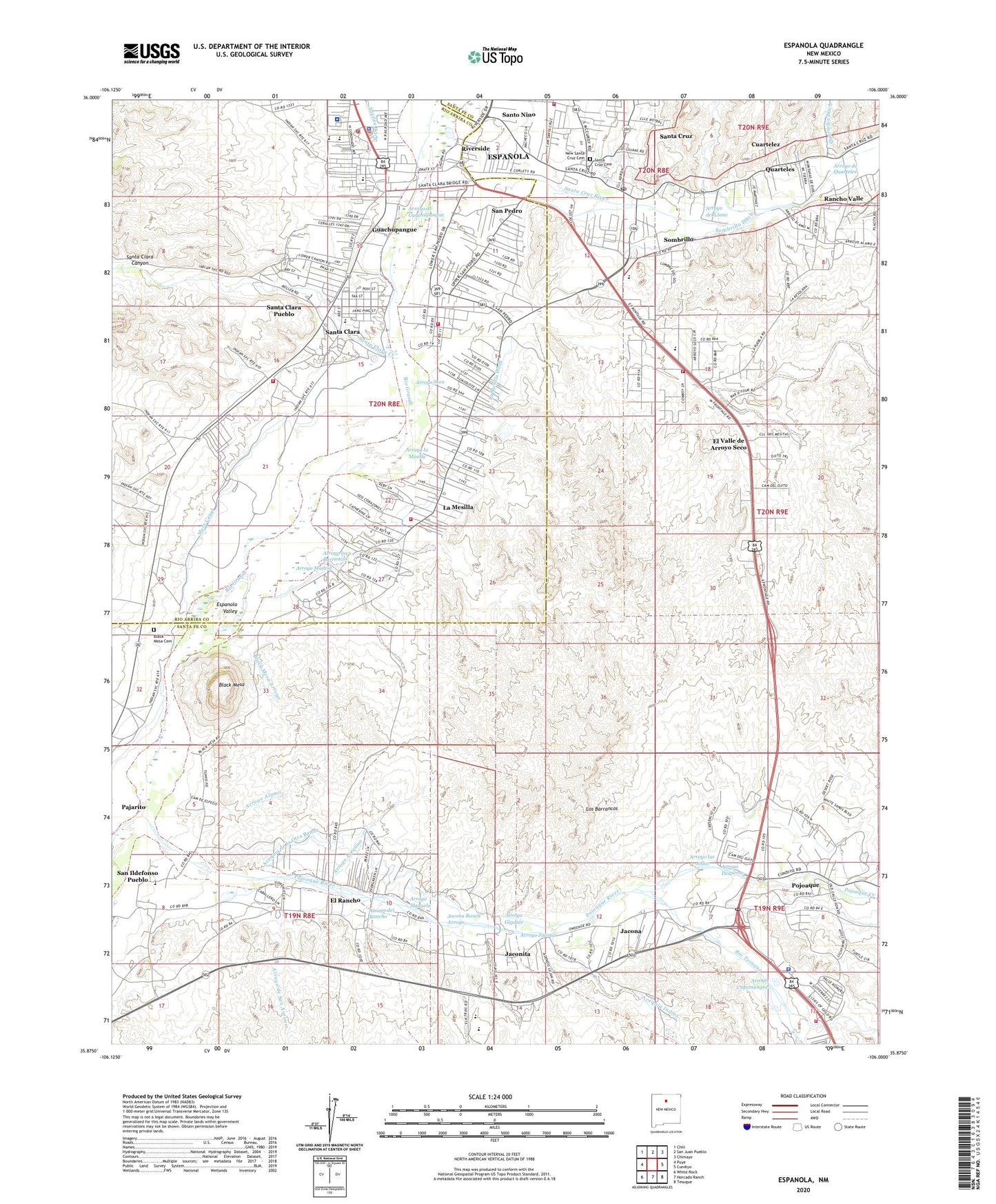
2023 topographic map quadrangle Espanola in the state of New Mexico. Scale: 1:24000. Based on the newly updated USGS 7.5' US Topo map series, this map is in the following counties: Santa Fe, Rio Arriba. The map contains contour data, water features, and other items you are used to seeing on USGS maps, but also has updated roads and other features. This is the next generation of topographic maps. Printed on high-quality waterproof paper with UV fade-resistant inks.
Quads adjacent to this one:
West: Puye
Northwest: Chili
North: San Juan Pueblo
Northeast: Chimayo
East: Cundiyo
Southeast: Tesuque
South: Horcado Ranch
Southwest: White Rock
This map covers the same area as the classic USGS quad with code o35106h1.
Contains the following named places: 10040 Water Well, 10160 Water Well, 10168 Water Well, 10172 Water Well, 10173 Water Well, 10177 Water Well, 10178 Water Well, 10180 Water Well, 10182 Water Well, 10196 Water Well, 10198 Water Well, 10250 Water Well, 10251 Water Well, 10253 Water Well, 2 Water Well, 3 Water Well, 87532, 87567, Acequia de Alamo, Acequia de la Otra Banda, Acequia Indios, Arroyo Acequias, Arroyo Alamo, Arroyo Ancho, Arroyo Cuyamungue, Arroyo de Guachupangue, Arroyo de Jaconito, Arroyo de Quarteles, Arroyo de San Antonio, Arroyo del Llano, Arroyo del Rancho, Arroyo Destierro, Arroyo Gigante, Arroyo Jacona, Arroyo la Mesilla, Arroyo las Jollas, Arroyo los Barrancos, Arroyo Madrid, Arroyo Manuela, Arroyo Seco, Black Mesa, Black Mesa Arroyo, Black Mesa Cemetery, Black Mesa Church, Black Mesa Ranch, Bond House Historic Site, Broken Arrow Ranch, Calvary Chapel, Chimayo Trading Post Historic Site, Church of God, Cities of Gold Casino, Cuartelez Census Designated Place, El Rancho, El Rancho Census Designated Place, El Rancho Ditch, El Rancho School, El Valle de Arroyo Seco, El Valle de Arroyo Seco Census Designated Place, Espanola, Espanola Elementary School, Espanola Fire Department Main Station, Espanola Fire Department Station 2, Espanola Hospital Library, Espanola Junior High School, Espanola Police Department, Espanola Public Library, Espanola Valley, Espanola Valley Emergency Medical Services, Espanola Weather Station, Evans Ranch, Firehouse Water Well, Franklin Ranch, Guachupangue, Holy Cross School, Ignacio Roybal House, Jacona, Jacona Census Designated Place, Jacona Ranch, Jacona Ranch Arroyo, Jaconita, Jaconita Census Designated Place, La Iglesia y la Plaza de Santa Cruz de la Canada Historic Site, La Mesilla, La Mesilla - San Pedro Volunteer Fire Department Main Station, La Mesilla Census Designated Place, La Mesilla Ditch, La Mesilla School, La Mesilla Volunteer Fire Department, La Puebla Census Designated Place, Los Barrancos, Main Canal, McCurdy Church, McCurdy Elementary School, McCurdy High School, McCurdy School, Mexican Ditch, New Santa Cruz Cemetery, Northern New Mexico Community College Library, Nuestra Senora de Guadalupe del Valle de Pojoaque, Ortiz Ditch, PLF-3 Water Well, Pojoaque, Pojoaque Census Designated Place, Pojoaque Church, Pojoaque Creek, Pojoaque Elementary School, Pojoaque High School, Pojoaque Intermediate School, Pojoaque Middle High School, Pojoaque Post Office, Pojoaque Pueblo Community Library, Pojoaque Pueblo Grant, Pojoaque Pueblo Police Department, Pojoaque River, Presbyterian Espanola Hospital, Pueblo of Pojoaque, Pueblo of San Ildefonso Historical Marker, Pueblo of Santa Clara Historical Marker, Pueblo Revolt Tricenteninnial Historical Marker, Quarteles, Quarteles Ditch, Rancho Valle, RG-13049 Water Well, RG-13516 Water Well, RG-14205 Water Well, RG-14819 Water Well, RG-14876 Water Well, RG-15033 Water Well, RG-1561 Water Well, RG-16252 Water Well, RG-1665 Water Well, RG-17304 Water Well, RG-17746 Water Well, RG-19330 Water Well, RG-21484 Water Well, RG-22097 Water Well, RG-23981 Water Well, RG-2420 Water Well, RG-26764 Water Well, RG-3301 Water Well, RG-3578 Water Well, RG-3735 Water Well, RG-4602 Water Well, RG-5758 Water Well, RG-6723 Water Well, RG-7223 Water Well, RG-8094 Water Well, RG-9396 Water Well, Rio Tesuque, Riverside, Rogers, RWP SI 3 Water Well, Saint Stephens Episcopal Church, San Antonio de Padua del Rancho, San Antonio Ditch, San Ildefonso Day School, San Ildefonso Pueblo, San Ildefonso Pueblo Census Designated Place, San Ildefonso Pueblo Grant, San Ildefonso Pueblo Museum, San Jose Number Thirteen Claim, San Pedro, Santa Clara, Santa Clara Canyon, Santa Clara Creek, Santa Clara Day School, Santa Clara Ditch, Santa Clara Post Office, Santa Clara Pueblo, Santa Clara Pueblo Census Designated Place, Santa Clara Pueblo Community Library, Santa Clara Pueblo Grant, Santa Clara Pueblo Volunteer Fire Department, Santa Cruz, Santa Cruz Cemetery, Santa Cruz Census Designated Place, Santa Cruz de la Canada Historical Marker, Santa Cruz Plaza on the Camino Real Historical Marker, Santa Cruz Post Office, Santa Cruz River, Santa Cruz United Methodist Church, Santa Fe County Volunteer Fire Department District Station 2 - La Puebla, Santa Fe County Volunteer Fire Department Pojoaque District Station 1, Santo Nino, Slash-h Ranch, Sombrillo, Sombrillo Census Designated Place, Sombrillo Ditch, Sombrillo Elementary School, Tsicumo, United Brethren Church, United Pentacostal Church, United Pentecostal Church, Valley View United Methodist Church, Victory Christian School, Vigiles Ditch, Well Ditch, Women's Club Cemetery