MyTopo
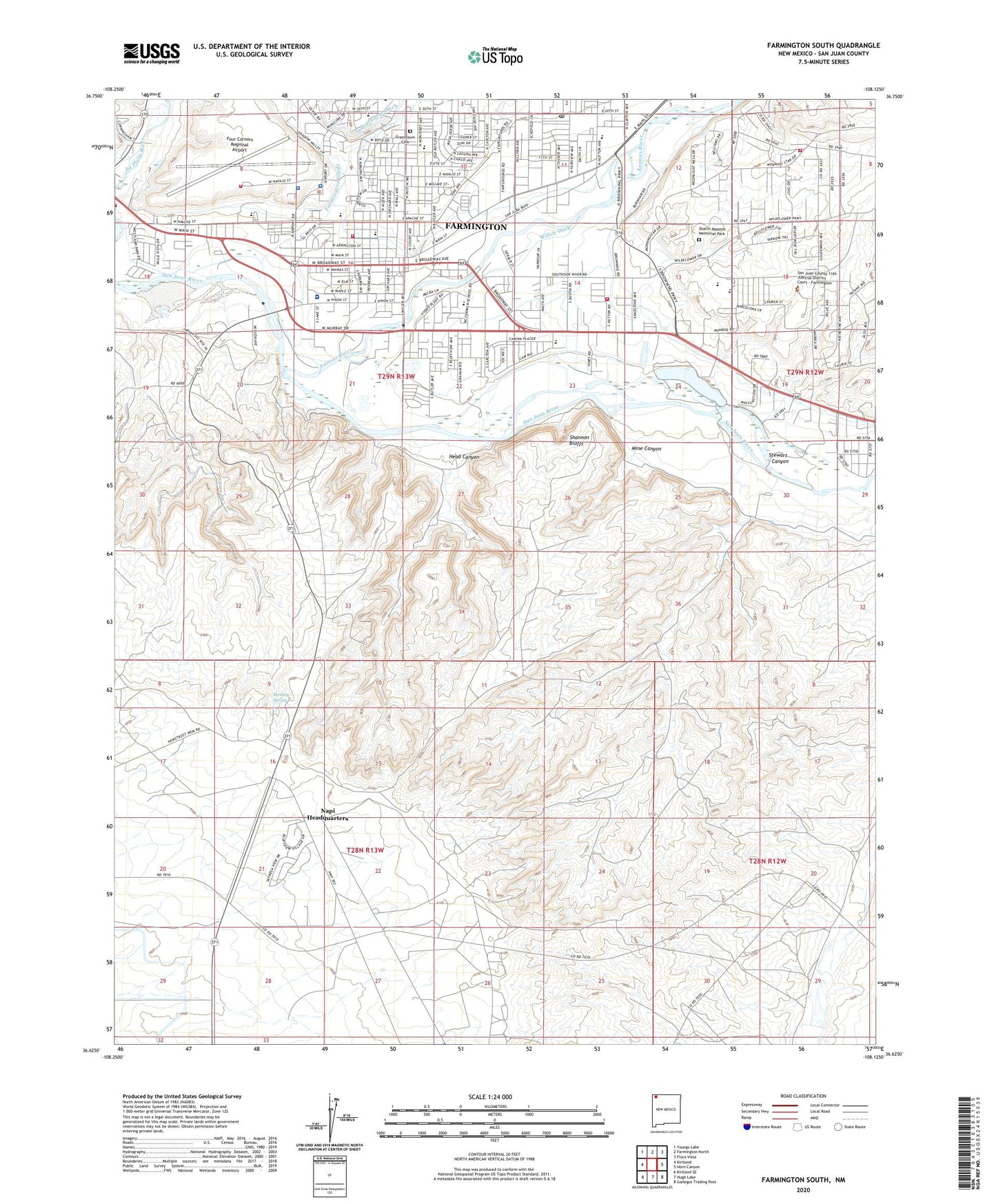
Farmington South New Mexico US Topo Map
Couldn't load pickup availability
2023 topographic map quadrangle Farmington South in the state of New Mexico. Scale: 1:24000. Based on the newly updated USGS 7.5' US Topo map series, this map is in the following counties: San Juan. The map contains contour data, water features, and other items you are used to seeing on USGS maps, but also has updated roads and other features. This is the next generation of topographic maps. Printed on high-quality waterproof paper with UV fade-resistant inks.
Quads adjacent to this one:
West: Kirtland
Northwest: Youngs Lake
North: Farmington North
Northeast: Flora Vista
East: Horn Canyon
Southeast: Gallegos Trading Post
South: Hugh Lake
Southwest: Kirtland SE
This map covers the same area as the classic USGS quad with code o36108f2.
Contains the following named places: Acora Pit, American Plaza, Animas Elementary School, Animas River, Animas Valley Mall, Apache School, Arco Pit, Bentley Spring, Beth Eden Baptist Church, Bethany Christian Church, Bloomfield Irrigation Ditch Historic Site, Bluffview School, Bolack Number One, Bolack Number One Dam, Boyd Park, Crestmoor Shopping Center, Dustin Masonic Memorial Park, East Side Rincon Historic Site, Eaton Pit, Echo Ditch, Farmington, Farmington Church of the Nazarene, Farmington Community Health Center, Farmington Fire Department - Station 4, Farmington Fire Department Station 1, Farmington Fire Department Station 3, Farmington Fire Department Station 6, Farmington Glade, Farmington high School, Farmington Historical Marker, Farmington Mennonite School, Farmington Museum, Farmington Police Department, Farmington Post Office, Farmington Public Library, Farmington Public Library East, Farmington Special Preschool, Farmington Weather Station, First Assembly of God Church, First Baptist Church, First Presbyterian Church, First United Methodist Church, Four Corners Regional Airport, Good Shepherd Presbyterian Church, Grace Baptist Academy, Greenlawn Cemetery, Head Canyon, Heights Junior High School, Hutton Plaza, Independent Ditch, Jaycee Park, KENN-AM (Farmington), Kiddie Kollege, KNDN-AM (Farmington), KNMI-FM (Farmington), KOBF-TV (Farmington), KPCL-FM (Farmington), KRAZ-FM (Farmington), KRWN-FM (Farmington), KSJE-FM (Farmington), KWYK-FM (Aztec), La Vida Missions, Lions Park, Living Word School, Main Street Mall, McCormick School, McKinley School, Mesa Shopping Center, Middle Fork Plaza, Mine Canyon, Napi Headquarters Census Designated Place, Navajo Academy B, Navajo Episcopal Mission, Navajo Free Methodist Church, Navajo Methodist Mission Cemetery, New Covenant United Methodist Church, New Mexico State Police District 10 Farmington, Night High School, North Farmington Ditch, Orchard Plaza, Palmer Plaza, Porter Arroyo, Red Shale Mine, Rocinate High School, Sacred Heart Parish, Saint Johns Episcopal Church, Salmon Historic Site, Salvation Army Farmington Corps Church, San Juan Archaeological Research Center Library, San Juan CCDC, San Juan College, San Juan College Library, San Juan Community College Library, San Juan County Fire District 14 Ojo Amarillo, San Juan County Fire District 8 - Hart Valley Station 2, San Juan Mission, San Juan Mission Cemetery, San Juan North Shopping Center, San Juan Plaza, San Juan Regional Medical Center, San Juan Regional Medical Center Library, San Juan Regional Rehabilitation Hospital, San Juan SDA School, Shannon Bluffs, Stewart Canyon, Sun Crest Hospital, Swinburne Elementary School, Taylor Mall, The Catholic Academy, The Dunes, Thomas Jefferson Arrington House Historic Site, Tibbetts Junior High School, Totah Vista, Totah Vista Census Designated Place, Trinity Assembly of God Church, Trinty Lutheran Church, Village Square, Willett Ditch, Williams Airport, ZIP Code: 87401