
MyTopo
Palo Flechado Pass New Mexico US Topo Map
Couldn't load pickup availability
Also explore the Palo Flechado Pass Forest Service Topo of this same quad for updated USFS data
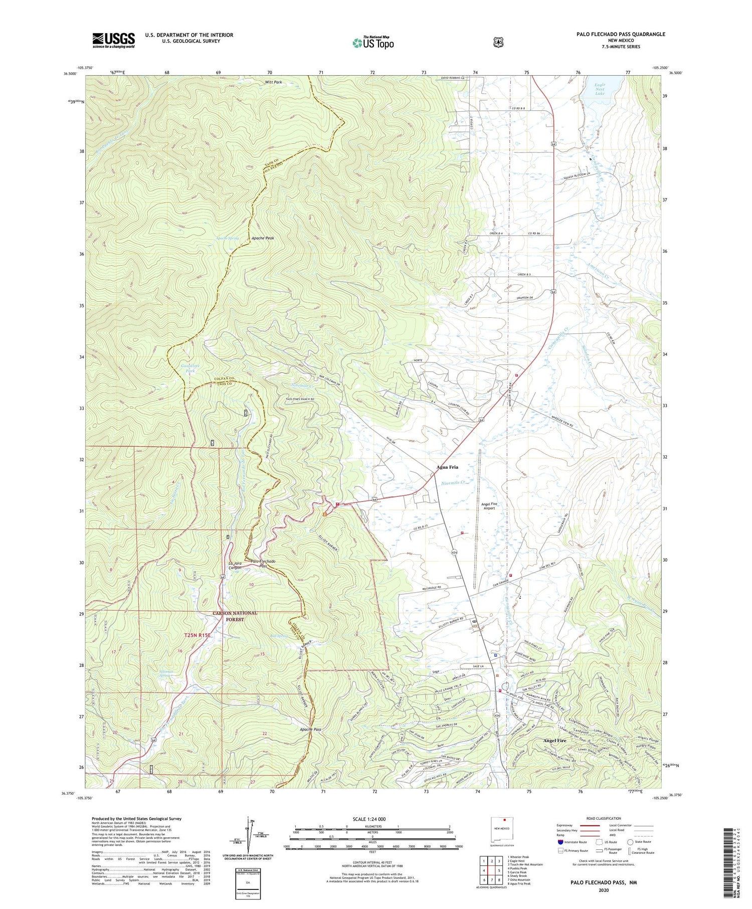
2023 topographic map quadrangle Palo Flechado Pass in the state of New Mexico. Scale: 1:24000. Based on the newly updated USGS 7.5' US Topo map series, this map is in the following counties: Colfax, Taos. The map contains contour data, water features, and other items you are used to seeing on USGS maps, but also has updated roads and other features. This is the next generation of topographic maps. Printed on high-quality waterproof paper with UV fade-resistant inks.
Quads adjacent to this one:
West: Pueblo Peak
Northwest: Wheeler Peak
North: Eagle Nest
Northeast: Touch-Me-Not Mountain
East: Garcia Peak
Southeast: Agua Fria Peak
South: Osha Mountain
Southwest: Shady Brook
This map covers the same area as the classic USGS quad with code o36105d3.
Contains the following named places: Adventure Trail Ski Trail, Agua Fria, Agua Fria Post Office, American Creek, Andreou, Angel Fire, Angel Fire Airport, Angel Fire Baptist Church, Angel Fire Community Church, Angel Fire Community Library, Angel Fire Department Station 1, Angel Fire Fire Department Station 3, Angel Fire Police Department, Angel Fire Post Office, Angel Fire Presbyterian Fellowship, Angel Fire Resort, Angel Fire Resort Golf Course, Angel Fire Ski Area, Angel Fire Ski Basin, Angel Food Ski Trail, Angels Plunge Ski Trail, Apache Pass, Apache Peak, Apache Spring, Arriba Ski Trail, Bodacious Ski Trail, Bull Spring, Charisma Ski Trail, Christ Our Savior Lutheran Mission Church, Exhibition Ski Trail, Fat City Ski Trail, Fire Escape Ski Trail, Free Flight Ski Trail, Go Round Ski Trail, Guajalote Park, Gully Cutoff Ski Trail, Hallelujah Ski Trail, Headin Home Ski Trail, Hells Bells Ski Trail, Highway Ski Trail, Hully Gully Ski Trail, I-25 Ski Trail, Jaspers Ski Trail, Joses Road Ski Trail, Kit Carson Ski Trail, La Bajada Ski Trail, La Jara Canyon, Leons Lane Ski Trail, Lift Number 1 Ski Trail, Lift Number 2 Ski Trail, Lift Number 4 Ski Trail, Lift Number Eight Ski Trail, Lift Number Five Ski Trail, Lift Number Three Ski Trail, Lower Minder Binder Ski Trail, Maxwells Grant Ski Trail, Minder Binder Ski Trail, Moes Road Ski Trail, Monte Verde Unit Two, Moreno Valley Fire Department Airport Station, Moreno Valley Fire Department Palo Felchado Station, Moreno Valley Fire Department Val Verde Station, Mother Lode Ski Trail, Myers, Nice Day Ski Trail, Ninemile Creek, Nose Dive Ski Trail, Palo Flechado Pass, Palo Flechado Pass Historical Marker, Prospector Ski Trail, Pueblo de Taos Indian Reservation, Ridge Run Ski Trail, Saladon Creek, Sangre de Cristo Camp, Silver Chute Ski Trail, Sluice Box Ski Trail, Soloman Spring, Trujillo, Upper Domingo Ski Trail, Valley Ski Trail, Village of Angel Fire, West Agua Fria Creek, Witt Park


