MyTopo
Red River New Mexico US Topo Map
Couldn't load pickup availability
Also explore the Red River Forest Service Topo of this same quad for updated USFS data
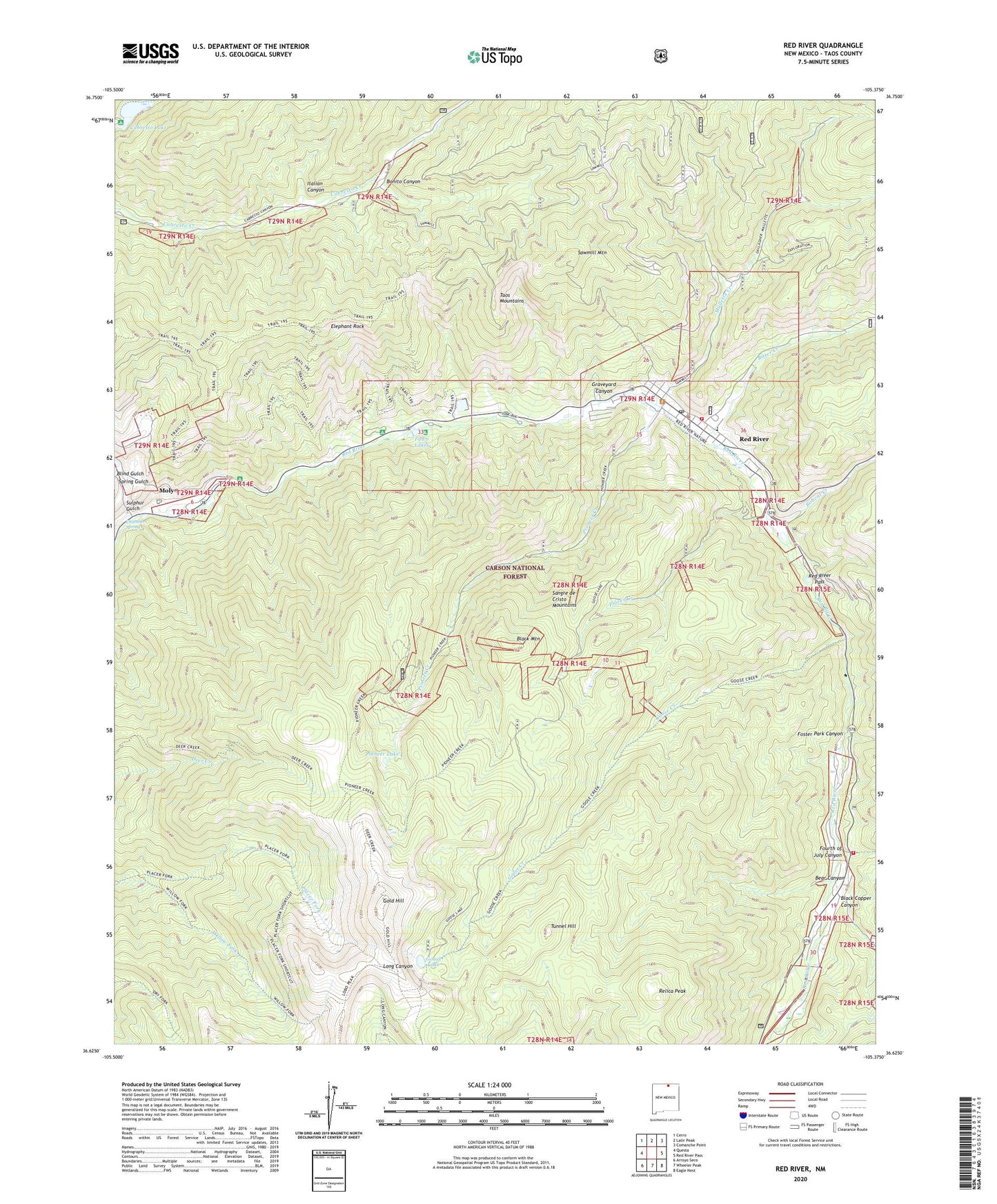
2023 topographic map quadrangle Red River in the state of New Mexico. Scale: 1:24000. Based on the newly updated USGS 7.5' US Topo map series, this map is in the following counties: Taos. The map contains contour data, water features, and other items you are used to seeing on USGS maps, but also has updated roads and other features. This is the next generation of topographic maps. Printed on high-quality waterproof paper with UV fade-resistant inks.
Quads adjacent to this one:
West: Questa
Northwest: Cerro
North: Latir Peak
Northeast: Comanche Point
East: Red River Pass
Southeast: Eagle Nest
South: Wheeler Peak
Southwest: Arroyo Seco
This map covers the same area as the classic USGS quad with code o36105f4.
Contains the following named places: Ajax Tunnel Prospect, Anderson Prospect, Bear Canyon, Beverly Prospect, Bitter Creek, Bitter Creek Group Mine, Bitter Creek Placer Mine, Black Copper Canyon, Black Mountain, Bobcat Creek, Bonito Canyon, Brigham J Young House Historic Site, Buffalo Mine, Bunker Hill Group, Bunker Hill Mine, Cabresta Canyon, Cabresto Lake, Cabresto Lake Campground, Cabresto Lake Prospect, Caribel Mine, Chambers Spring, Copper King Mine, Creek Tunnel Prospect, Crowe Adit, Edward P Westoby Cabin Historic Site, Elephant Rock, Elephant Rock Campground, Entrance Tunnel Prospect, Esther Prospect, Ethel Group, Faith Mountain Fellowship Church, Fawn Lakes, Fawn Lakes Campground, Foster Park Canyon, Fourth of July Canyon, Gilt Edge Placer, Gold Hill, Gold Reef Prospect, Golden Goose, Golden Treasure Group, Goose Creek, Goose Lake, Granite, Graveyard Canyon, Hillside Prospect, Hilltop Gold Placer Prospect, Hornet Group, Indiana, Inferno Group, Ione, Iron King Prospect, Italian Canyon, Jay Hawk Mine, Jefferson Prospect, June Bug Campground, Lone Star Lode, Mallette Campground, Mallette Creek, Melson-Oldham Cabin Historic Site, Moberg Group, Moly, Nashville Prospect, Orin Mallette Cabin Historic Site, Pierce-Fuller House Historic Site, Pioneer Creek, Pioneer Lake, Placer Creek, Purkapile Prospect, Questa Ranger District, Ragged Pants Dick Prospect, Raton Group, Red River, Red River Community House, Red River Elementary School, Red River Fire Department, Red River Marshal's Office, Red River Post Office, Red River Schoolhouse, Red River Ski Area, Red River Weather Station, Relica Peak, Saint Edwin Chapel, Saint Edwins Catholic Church, Sampson Prospect, Sawmill Mountain, Scarlet Group, Silver King Prospect, Silver Tip Group, Spring Gulch, Stella Prospect, Sulphur Gulch, Sylvester M Mallette Cabin Historic Site, Sylvia Tunnel, Tom Boy, Town of Red River, Tunnel Hill, Victor Number Two Prospect, Wheeler Peak Fire District - Fourth - of - July Canyon Station, Willard Prospect, Willow Fork, Willow Placer, ZIP Code: 87558