MyTopo
Bay Shore East New York US Topo Map
Couldn't load pickup availability
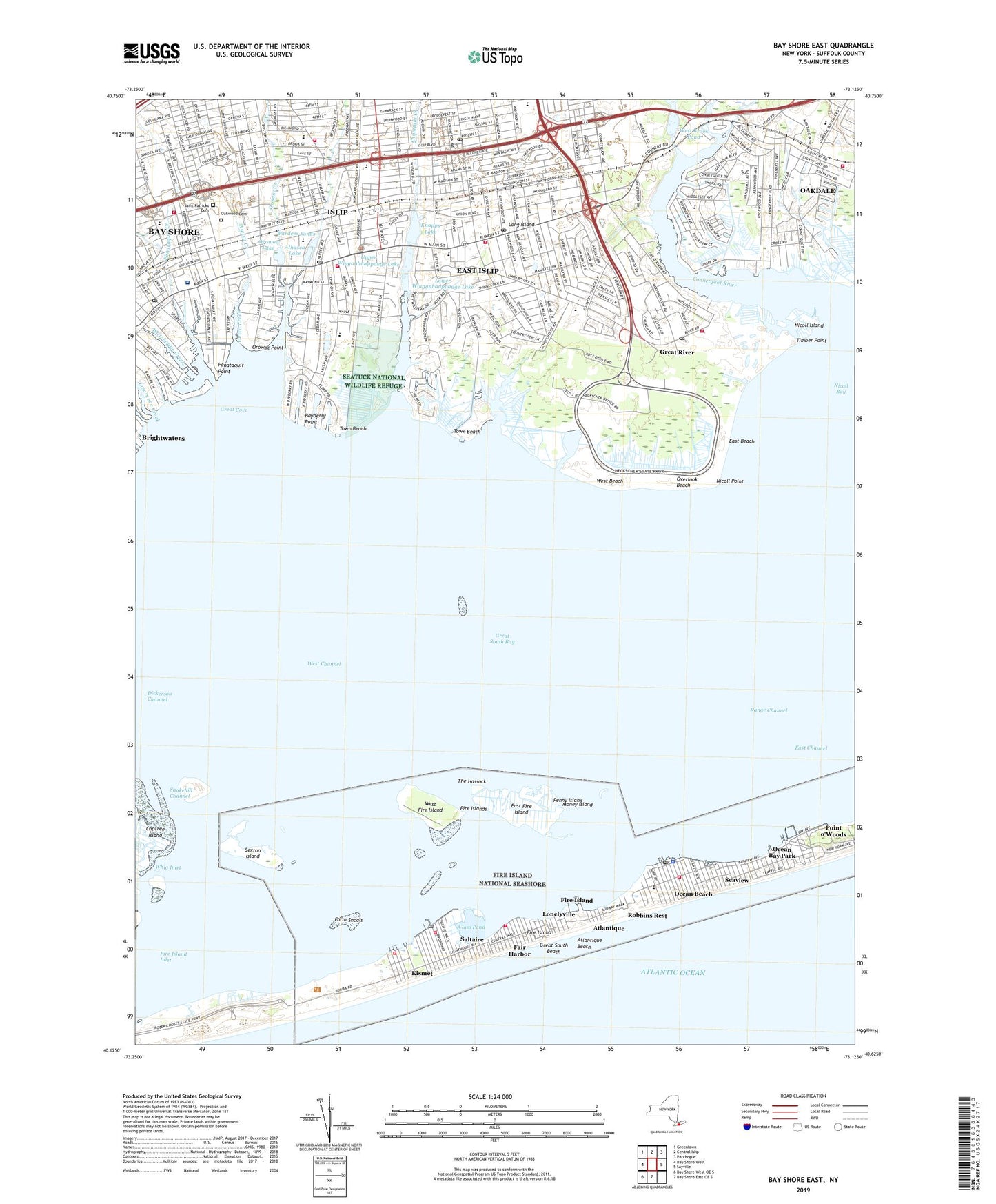
2023 topographic map quadrangle Bay Shore East in the state of New York. Scale: 1:24000. Based on the newly updated USGS 7.5' US Topo map series, this map is in the following counties: Suffolk. The map contains contour data, water features, and other items you are used to seeing on USGS maps, but also has updated roads and other features. This is the next generation of topographic maps. Printed on high-quality waterproof paper with UV fade-resistant inks.
Quads adjacent to this one:
West: Bay Shore West
Northwest: Greenlawn
North: Central Islip
Northeast: Patchogue
East: Sayville
South: Bay Shore East OE S
Southwest: Bay Shore West OE S
This map covers the same area as the classic USGS quad with code o40073f2.
Contains the following named places: Abundant Life Christian Fellowship, Athasca Lake, Atlantique, Atlantique Beach, Atria Bay Shore, Authors Playhouse, Awixa Creek, Bay Shore, Bay Shore Armory, Bay Shore Brightwaters Rescue Ambulance Service, Bay Shore Census Designated Place, Bay Shore Fire Station, Bay Shore Marina, Bay Shore Sunrise Drive-In, Bay Shore United Methodist Church, Bay Shore Village Shopping Center, Bayberry Point, Bayberry Yacht Club, Bayway Arts Center, Benjamin's Memorial Beach, Bethel African Methodist Episcopal Church, Bnai Israel Reform Temple, Boulton Center for the Performing Arts, Brightwaters Beach And Cabana Club, Brook Avenue Elementary School, Brookwood Hall, Brookwood Hall Park, Bull Ditch, Byron Lake Park, Champlin Creek, Christ Lutheran Church, Christian Reformed Church, Clam Pond, Commack Road Elementary School, Connetquot Brook, Connetquot River, Curtin Student Center, Deer Run, Dickerson Channel, Dowling College Rudolph Campus, Duck Pond, East Beach, East Canal, East Channel, East Fire Island, East Islip, East Islip Census Designated Place, East Islip Fire Station, East Islip High School, East Islip Junior High School, East Islip Marina, East Islip Post Office, East Islip Public Library, East Pond, Emmanuel Church, Fair Harbor, Fair Harbor Fire District, Farm Shoals, Fire Island, Fire Island Census Designated Place, Fire Island Ferry Terminal, Fire Island Life Saving Station, Fire Island Light Station, Fire Island Lighthouse Visitors Center, Fire Island School, Fire Island Synagogue, Fire Islands, First Congregational Church of Bay Shore, Fortunoff Hall, Gospel Lighthouse Pentecostal Church, Grand Canal, Great Bay Shore Shopping Center, Great Cove, Great River, Great River Census Designated Place, Great River Fire Station, Great River Post Office, Great River Station, Heckscher Canal, Heckscher State Park, Hewlett School of East Islip, Idle Hour Elementary School, Iglesia Apostolica Fuente Del, Iglesia de Salvacion, Islip, Islip Art Museum, Islip Census Designated Place, Islip Elementary School, Islip Fire Department, Islip Fire Station, Islip High School, Islip Meadows County Nature Preserve, Islip Middle School, Islip Post Office, Islip Public Library, Islip Station, Islip Terrace, Islip Terrace Junior High School, Islip Terrace Post Office, Islip Terrace Professional Building, Islip Town Hall, John F Kennedy Elementary School, Kismet, Kismet Fire District Headquarters, Kismet Fire District Substation, Knapps Lake, Kramer Science Center, Lawrence Creek, Little Flower for Rehabilitation and Nursing, Lonelyville, Lower Pond, Lower Winganhauppauge Lake, Main Street School, Maude S Sherwood Elementary School, Mayfair Nursing Home, Middle Canal, Money Island, Montfort Seminary, New Beginnings Church, Nicoll Bay, Nicoll Island, Nicoll Point, NMY, North Great River, Oakdale, Oakdale - Bohemia Junior High School, Oakdale Census Designated Place, Oakdale Station, Oakwood Cemetery, Ocean Bay Park, Ocean Bay Park Fire District, Ocean Beach, Ocean Beach Fire Department, Ocean Beach Post Office, Orowoc Creek, Orowoc Lake, Orowoc Point, Our Lady Star of the Sea Church, Overlook Beach, Pardees Ponds, Pearl Garden Manor Assisted Living Facility, Penataquist Methodist Church, Penataquit Creek, Penataquit Point, Penataquit Post Office, Penny Island, Point O' Woods Fire District, Point of Woods Life Saving Station, Point o'Woods, Premm Learning Center, Presbyterian Church of Islip, Quintuck Creek, Racanelli Center, Range Channel, Rattlesnake Brook, Robbins Rest, Saint Andrews by the Sea Church, Saint Mark's Episcopal Church, Saint Mary's Roman Catholic Church, Saint Marys School, Saint Patricks Cemetery, Saint Stephens Anglican Church, Saltaire, Saltaire Post Office, Saltaire Village Fire Department, Sanford Lake, Seatuck National Wildlife Refuge, Seaview, Sexton Island, Snakehill Channel, Soldier And Sailors Memorial Building, South Shore Mall Shopping Center, Southside Hospital, Sunrise Business Center, Sunrise Manor Center for Nursing and Rehabilitation, Temple Sinai of the South Shore, The Hassock, The Moorings, The Unitarian Universalist Society of South Suffolk, Timber Point, Timber Point Country Club, Timber Point Elementary School, Town Beach, Town of Islip, Trinity Lutheran Church, United Methodist Church of Islip, Upper Winganhauppauge Lake, Village of Ocean Beach, Village of Saltaire, Watchogue Creek, West Beach, West Brook, West Brook Pond, West Canal, West Channel, West Fire Island, West Sayville Fire District Station 2, Whig Inlet, ZIP Codes: 11730, 11739, 11751, 11769, 11770