MyTopo
Sayville New York US Topo Map
Couldn't load pickup availability
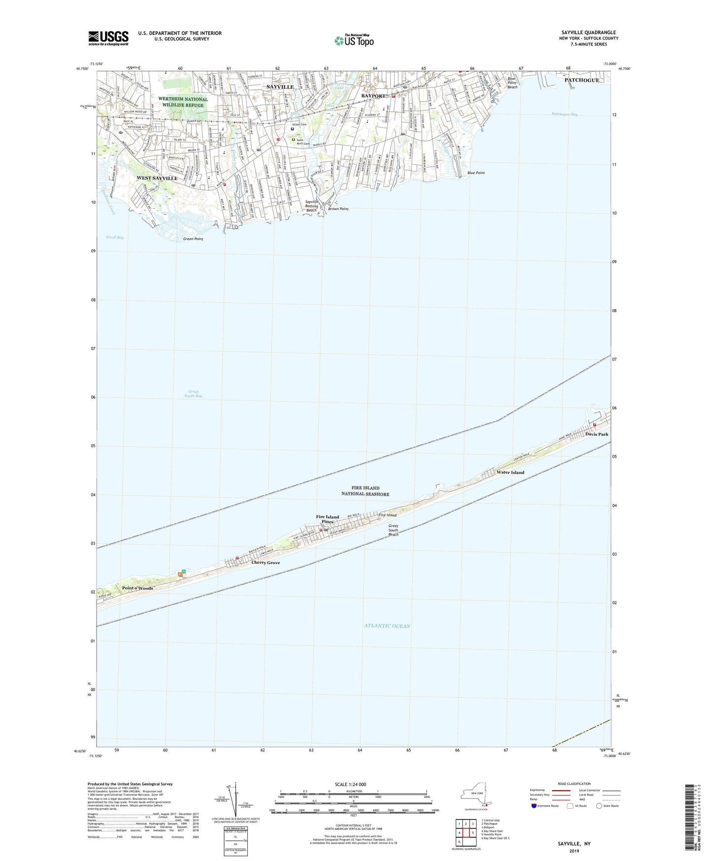
2023 topographic map quadrangle Sayville in the state of New York. Scale: 1:24000. Based on the newly updated USGS 7.5' US Topo map series, this map is in the following counties: Suffolk. The map contains contour data, water features, and other items you are used to seeing on USGS maps, but also has updated roads and other features. This is the next generation of topographic maps. Printed on high-quality waterproof paper with UV fade-resistant inks.
Quads adjacent to this one:
West: Bay Shore East
Northwest: Central Islip
North: Patchogue
Northeast: Bellport
East: Howells Point
Southwest: Bay Shore East OE S
This map covers the same area as the classic USGS quad with code o40073f1.
Contains the following named places: Academy Street Elementary School, Adelphi College Suffolk Division, Barrett Beach Park, Bayport, Bayport - Blue Point High School, Bayport - Blue Point Public Library, Bayport Census Designated Place, Bayport Commons Park, Bayport Fire Department, Bayport Post Office, Bayport Pumping Station, Bayport Station, Bayport United Methodist Church, Blue Point, Blue Point Beach, Blue Point Bible Church, Blue Point Elementary School, Blue Point Life Saving Station, Brown Creek, Brown Point, Cherry Avenue Elementary School, Cherry Grove, Cherry Grove Ferry, Cherry Grove Fire District, Christian Reformed Church, Corey Creek, Davis Park, Davis Park Ferry, Davis Park Marina, Davis Park Volunteer Fire Department, Fire Island, Fire Island National Seashore, Fire Island Pines, Fire Island Pines Ferry, Fire Island Pines Fire District, Fire Island Pines Post Office, First Reformed Church, Glory Tabernacle Church, Good Samaritan Nursing Home, Gospel Community Church, Grace Chapel Assembly of God, Great South Bay, Great South Beach, Green Creek, Green Point, Greenes Lake, Hard Estate-West Sayville County Park, Homans Creek, House of Judah, Indian Creek, LaSalle Military Academy, Little Creek, Lone Hill Life Saving Station, Lotus Lake, Ludlows Creek, Mill Pond, Namkee Creek, Oakdale Post Office, Our Lady of the Snow Roman Catholic Church, Patchogue Bay, Patchogue River, Pleasant Gardens Home for Adults, Prince of Peace Regional School, Roosevelt Estate County Park, Sailors Haven Ferry Terminal, Saint Ann's Cemetery, Saint Ann's Episcopal Church, Saint John Episcopal Church, Saint John's Lutheran Church, Saint Lawrence The Martyr Roman Catholic Church, Saint Mary's Malankara Orthodox Church, Sayville, Sayville Bathing Beach, Sayville Census Designated Place, Sayville Congregational Church, Sayville Elementary School, Sayville Fire District Station 1, Sayville Heights, Sayville High School, Sayville Industrial Park, Sayville Library, Sayville Post Office, Sayville Station, Sayville United Methodist Church, Shoreham Hotel, Sons And Daughters Of Liberty Home For The Aged, Sparrow Park, Stillman Creek, Suffolk County Marine Museum West, Sunken Forest, Tuthills Creek, Union Cemetery, Water Island, Waterfront Floating Helistop, West Oaks Recreation Club Camp, West Sayville, West Sayville Census Designated Place, West Sayville Christian School, West Sayville Fire District Station 1, West Sayville Golf Course, West Sayville Post Office, West Sayville Reformed Bible Church, White House Farm, ZIP Codes: 11705, 11782, 11796