MyTopo
Chautauqua New York US Topo Map
Couldn't load pickup availability
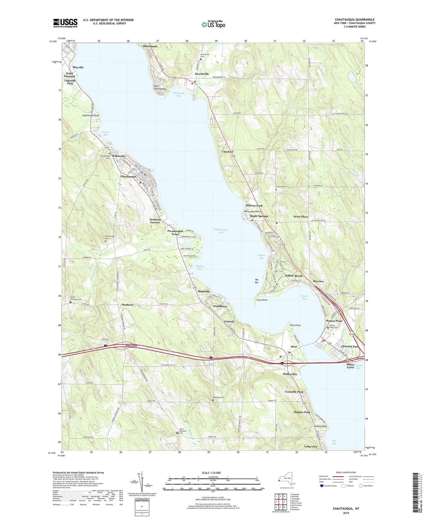
2023 topographic map quadrangle Chautauqua in the state of New York. Scale: 1:24000. Based on the newly updated USGS 7.5' US Topo map series, this map is in the following counties: Chautauqua. The map contains contour data, water features, and other items you are used to seeing on USGS maps, but also has updated roads and other features. This is the next generation of topographic maps. Printed on high-quality waterproof paper with UV fade-resistant inks.
Quads adjacent to this one:
West: Sherman
Northwest: Westfield
North: Hartfield
Northeast: Cassadaga
East: Ellery Center
Southeast: Lakewood
South: Panama
Southwest: North Clymer
This map covers the same area as the classic USGS quad with code o42079b4.
Contains the following named places: Ashville Fire District Station, Ball Creek, Bayview, Bemus Bay, Bemus Creek, Bemus Point, Bemus Point Cemetery, Bemus Point Elementary School, Bemus Point Golf Club, Bemus Point Hatchery, Bemus Point Post Office, Bemus Point Public Library, Bemus Point United Methodist Church, Bemus Point Universalist Church, Bemus Point Volunteer Fire Department, Big Bar, Bly Bay, Browns Creek, Camp Merz, Camp Newatah, Central School, Chautauqua, Chautauqua Cemetery, Chautauqua Census Designated Place, Chautauqua Golf Club, Chautauqua Heights Camping Resort, Chautauqua Institution, Chautauqua Lake, Chautauqua Point Golf Club, Chautauqua Post Office, Chautauqua Volunteer Fire Department, Chedwel, Cheney Point, Connelly Park, Cottage Park, Dewittville, Dewittville Bay, Dewittville Cemetery, Dewittville Creek, Dewittville Fire Department, Dewittville Hartfield United Methodist Church, Dewittville Post Office, Elm Tree, Hadley Bay, Haff Acres Farm, Irwins Bay, Lakeside Park, Lewis Cemetery, Lighthouse Point, Long Point, Magnolia, Maple Cider Farms, Maple Springs, Maple Springs Fire Company, Maple Springs Post Office, Midway Drive-In, Midway Park, North Harmony Cemetery, North Harmony Town Hall, Notre Dame Du Lac Diocesan House of Studies, Open Meadows Cemetery, Open Meadows Church, Orchard Terrace, Oriental Park, Our Lady of Lourdes Roman Catholic Church, Point Chautauqua, Point Pleasant, Prendergast Cemetery, Prendergast Creek, Prendergast Point, Quigley Park, Shore Acres, Shorelands, Smith Memorial Library, Stedman, Stow, Stow Post Office, Sunset Bay, Toms Point, Town of North Harmony, Unorganized Territory of Chautauqua Lake, Victoria, Village of Bemus Point, Village Park, Wahmeda, Walker Seaplane Base, Waterman Corner, West Ellery, Whitesides Point, Whitney Bay, Wild Rose Cemetery, Willow Brook, Willow Run Golf Course, Wing Creek, Woodlawn, ZIP Codes: 14722, 14756