MyTopo
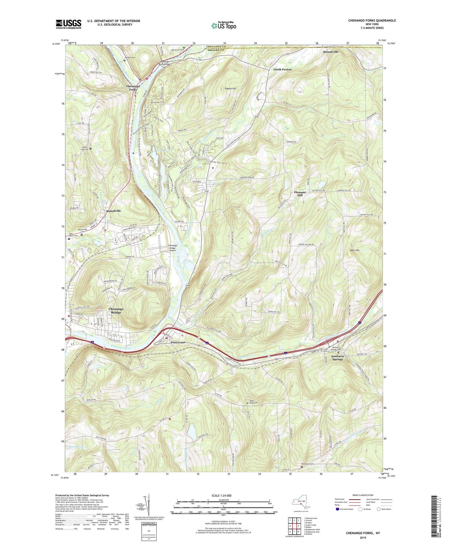
Chenango Forks New York US Topo Map
Couldn't load pickup availability
2023 topographic map quadrangle Chenango Forks in the state of New York. Scale: 1:24000. Based on the newly updated USGS 7.5' US Topo map series, this map is in the following counties: Broome, Chenango. The map contains contour data, water features, and other items you are used to seeing on USGS maps, but also has updated roads and other features. This is the next generation of topographic maps. Printed on high-quality waterproof paper with UV fade-resistant inks.
Quads adjacent to this one:
West: Castle Creek
Northwest: Whitney Point
North: Greene
Northeast: Brisben
East: Belden
Southeast: Windsor
South: Binghamton East
Southwest: Binghamton West
This map covers the same area as the classic USGS quad with code o42075b7.
Contains the following named places: Ballyhack Creek, Barlow School, Brookvale, Brookvale Cemetery, Broome County, Charlotte Kenyon Elementary School, Chenango Bridge, Chenango Bridge Airport, Chenango Bridge Census Designated Place, Chenango Bridge Elementary School, Chenango Bridge United Methodist Church, Chenango Bridge Volunteer Fire Company Station 1, Chenango Bridge Volunteer Fire Company Station 2, Chenango Forks, Chenango Forks Central School, Chenango Forks Fire Company, Chenango Forks High School, Chenango Forks Middle School, Chenango Forks Post Office, Chenango Lake, Chenango River Bridge, Chenango Valley Central School, Chenango Valley State Park, Chenango Valley State Park Golf Course, Cold Spring Farm, Collins - Hall Cemetery, Fenton Mobile Home Park, Fenton Town Hall, First Baptist Church of Port Crane, First Church of Christ, Five Mile Point Fire Company, Forest Manor, Gilbert Creek, Hickory Ridge Mobile Home Park, Holy Spirit Cemetery, Holy Trinity Lutheran Church, Hunt Hill, John R Harshaw Primary School, Kattell Creek, Kattellville, Kattellville Cemetery, Lily Lake, Living Hope Alliance Church, Mountain View Trailer Park, North Fenton, Oak Grove Cemetery, Osborne Creek, Page Brook, Pigeon Hill, Pleasant Hill, Pleasant Hill School, Port Crane, Port Crane Fire Company Station 1, Port Crane Fire Company Station 2, Port Crane Post Office, Port Crane United Methodist Church, Porter Creek, Quinneville, Riverside Mobile Home Park, Russwick Farms, Saint Joseph's Church, Saint Marks Episcopal Church, Saint Ritas Church, Sanitaria Springs, Sanitaria Springs Cemetery, Sanitaria Springs Fire Company, Sanitaria Springs Methodist Church, School Number 23, School Number 3, School Number 5, School Number 6, School Number 7, School Number 8, Sheepbrook Farms, State Road Cemetery, Tioughnioga River, Toombs Cemetery, Town of Fenton, Valley Christian Reformed Church, Virginia City Mobile Home Court, Wyman Corner, ZIP Codes: 13833, 13904